Rondolon
| Rating: | |||||||||||||||||||||||||||||||
|---|---|---|---|---|---|---|---|---|---|---|---|---|---|---|---|---|---|---|---|---|---|---|---|---|---|---|---|---|---|---|---|
|
| |||||||||||||||||||||||||||||||
| | Raps:max ↨66ft
Red Tape: Shuttle:None Rock type:Limestone | ||||||||||||||||||||||||||||||
| Location: | |||||||||||||||||||||||||||||||
| Condition Reports: | |||||||||||||||||||||||||||||||
| Best season: | Jun-Oct
|
||||||||||||||||||||||||||||||
| Regions: | |||||||||||||||||||||||||||||||

Introduction
Rio Rondolon is a left tributary of Torrente Dogna in the Val Dogna valley. Rio Rondolon is just like ¨his brother¨ Rio Sfonderat located in extremely wild environment below the north face of Monte Cimone mountain. It’s a varied canyon with some narrow parts, little jumps and slides but also with a good deal of walking and downclimbing. You can find some really nice deep green pools, clean water and untouched nature. The approach is long and partly trackless but not too difficult.
Zone Friuli – Udine – Val Dogna
Details Entrance: 850m Exit: 550m Height: 300m Length: 1250m
Period June – October
Dimensoins Approach: 2 h Progression: 3 h Return: 30 min
Shuttle No
Equipement Sufficent, 10mm spits and slings. Not all waterfalls are bolted – some tricky downclimbs
Rope 2x20m or 1X40m
Possible Exits None in the upper part, several in the lower part (always on the right side)
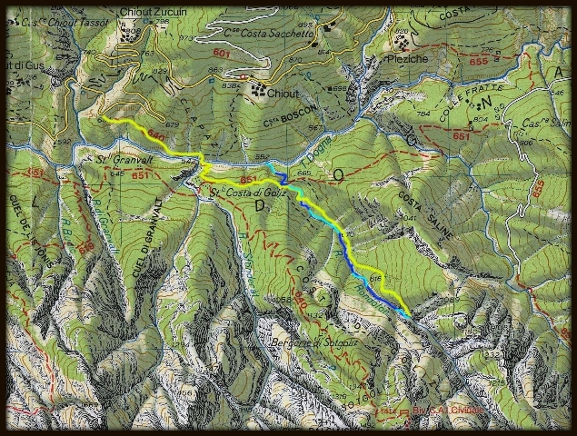
Maps Tabacco Map 018
Attraction Local
Difficulty V3 A3 III
Approach
Leave the SS13 in Dogna and follow the road into Val Dogna. Follow the street until you cross Rio Mas. A little bit further uphill you reach a big parking place after a sharp bend in the road. On the tree on the right side is a sign CAI 640 for the marked path for the Monte Cimone.
Follow the marked hiking path 640 down into the valley. After about 15min you will have to cross Torrente Dogna, the bridge that used to be there has been swept away. Go up steeply on the other side of the valley until you can see some ruins above you. Turn left in the last switchback before you reach the ruins (this used to be path 651). Follow the abandoned path until you reach the creekbed of Rio Rondolon (steep and slippery in the last part). Follow the creekbed until you see a big waterfall, here go up the eastern bank of the creek until you see an old path (probably also reachable by staying on the eastern bank after crossing Rio Rondolon). Follow this path into the valley. Soon you will walk above the narrow but tiny canyon of Rio Rondolon. Ascend through a nice wood while keeping the creek on your right. Before you reach a steep wall turn left until you stand before a dry creekbed. Here you can either climb up through the creekbed (slippery) or ascend very steeply to the right on a game trail. Go up until you reach a small saddle from where you can see into the valley of Rio Rondolon. Descend a steep scree slope, when the slope gets rocky cross to the left into another steep slope until you finally reach the creekbed.
Descent
100m D + walking between big blocks
C 4m: 1 spit (L)
50m D + walking
D 3m: (L)
C 12m 1 spit (R)
D or S3m: shallow pool (L)
S 5m: or rappel from sling on stuck tree
C 7m 1 spit (R)
End of the first canyon part
50 m of walking
D 4m: (L)
100m easy walking
S 3m: (R)
D 5+5m
C 12m: tree (unequipped), D also possible (L)
S 3m
C 17m: tree with rope (R)
150m D + walking
S 5m: (L)
C 15m: 1 spit (L)- possible jump from the small ledge 5m
200m D + walking (meeting with marked path CAI 652)
C 11m: 1 spit (L), maybe jumpable
C 11m: tree with rope (L)
D 3m: (R)
S 2m
50m D +walking until you reach Torrente Dogna
Exit
Go down the creekbed until you reach the destroyed bridge, then follow path 640 back to the car
Red tape
Beta sites
 Canyon.Carto.net : Rio Rondolon
 Descente-Canyon.com : Rondolon
Trip reports and media


Background
Equipped by Canyoning Cult Slovenia (Urška Bricelj, David Sefaj, Roman Udir), Andi Aichholzer, Georg Buol on 12th July 2014