Zanaibach Canyoneering Canyoning Caving descenso de barrancos Barranquismo
Also known as: Zanai; Zanaibach; Zanaibach inferiore; Zanaibach superiore.
|
| Rating: |
Log in to rateLog in to rateLog in to rateLog in to rateLog in to rate 4.2 (20 ratings) |
|

|
| |
Raps:max ↨148ft | Overall: | 3-6.5h | |
|---|
| 30-50min | | | | 2-5.5h | ⟷0.9mi | ↑755ft | | 15-20min | | |
No Shuttle:None Rock type:Slate |
|---|
| Location: |
|
|---|
| |
|---|
| Condition Reports: |
(log in to submit report)
|
|---|
Weather: |
|
|---|
| Best season: |
Jul-Aug;Aug | winter | | spring | | summer | | fall |
|---|
| Dec | Jan | Feb | | Mar | Apr | May | | Jun | Jul | Aug | | Sep | Oct | Nov |
|
| Regions: |
|
http://descente-canyon.com/canyoning/canyon-description/21337,http://canyon.carto.net/cwiki/bin/view/Canyons/ZanaibachCanyon,http://barranquismo.net/paginas/barrancos1/zanaibach.htm,http://schlucht.ch/schluchten-der-schweiz-navbar.html?cid=46,http://schlucht.ch/schluchten-der-schweiz-navbar.html?cid=1,http://ropewiki.com/User:Canyoning_in_the_Swiss_Alps_Book?id=Zanaibach
http://descente-canyon.com/canyoning/canyon-description/21337,http://canyon.carto.net/cwiki/bin/view/Canyons/ZanaibachCanyon
46.9633, 9.4643https://ropewiki.com/luca/rwr?gpx%3Doff&filename%3DZanaibach&kmlnfx&kmlx%3Dhttp://descente-canyon.com/canyoning/canyon-description/21337&ext%3D.kmlchtopo
GPS data automatically extracted from
descente-canyon.com, please visit their site for more detailed information.
(log in to submit reference picture)
Introduction
Acceso desde: Valente
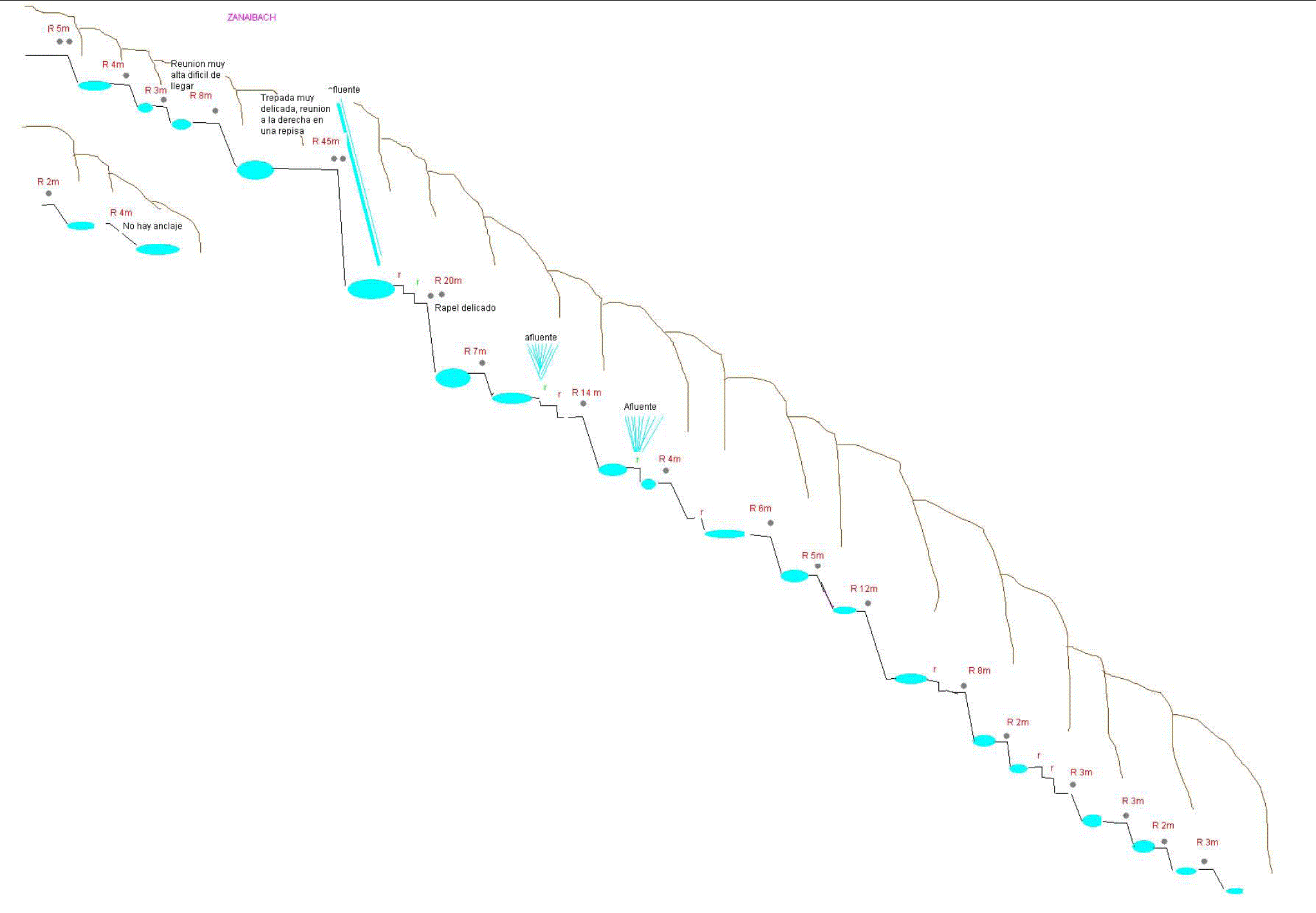
Altura de rápel mas largo: 45m
Información del caudal: Cañón con abundante caudal todo el año
Material necesario: 2X50 mts
Neopreno: completo, agua muy fría
Material de instalación: Aconsejable llevar material de instalación de repuesto, y algún mayon y algún cordino
Época: Cañón Glaciar, de Octubre y noviembre las mejores épocas, luego con hielo en febrero
Observaciones: Algunas reuniones muy expuestas, mínimo de técnica de escalada. Evaluar muy bien el caudal, los vecinos recomiendan un máximo de 150/ls
Horario de aproximación: 30 min
Horario de descenso: 2 a 4 h
Horario de retorno: 15 min
Carácter: Engorgado
Tipo de roca: Pizarra
Approach
Salida de la autopista de Bad Ragaz y seguir la dirección de Valente. Aparcar en el extremo de la aldea de Valente a los bomberos. No trate de estacionarse en la pista o en las ranuras libres en el lado de la carretera. Continuar dirección al puente, cualquiera de las 2 entradas al GR, van al mismo sitio, desde el puente podremos hacer una primera estimación del caudal. Continuaremos andando por el Gr, hasta llegar a un puente de madera,de aquí haremos la ultima estimación de caudal, hay gente que rapela desde aquí, pero ya te dejas algo del descenso, si quieres hacer algún rapel mas y vale la pena, continuar unos 300 metros mas arriba y bajar al río por lo mas evidente.
Descent
Impresionante CAÑON, muy técnico. El el rapel largo la reunión esta muy expuesta, hay que escalar un poco. el rapel de 20, bajas por todo el caño, y pillas. Sin lugar a duda, a programar.
Escapes: No hay posibilidad de escaparse, paredes mínimas de 50mts
Exit
Una vez acabado el tramo deportivo a mano izquierda orográfica, salir por lo mas evidente asta el puente.
Red tape
Beta sites
Trip reports and media
Picture Credit : Matthias Holzinger
Background
26-Feb-2011 Bannanas

 Descente-Canyon.com : Zanaibach
 Canyon.Carto.net : Zanaibach
 Barranquismo.net : Zanaibach
 Canyoning in the Swiss Alps Book by Association Openbach : Zanaibach