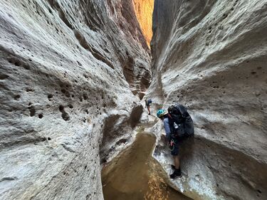
150 Mile Canyon
Rating: | |||||||||||||||||||||||||||||||
---|---|---|---|---|---|---|---|---|---|---|---|---|---|---|---|---|---|---|---|---|---|---|---|---|---|---|---|---|---|---|---|
| Difficulty:3B VI (v3a2 VI) Raps:max ↨50ft
Red Tape:Permit required Shuttle: | ||||||||||||||||||||||||||||||
Location: | |||||||||||||||||||||||||||||||
Condition Reports: | 24 Mar 2025
"Ill give it five stars, as the main section of slot - which only lasts maybe 30 minutes - is an absolutely stunning white hallway. But, be prepared t |
||||||||||||||||||||||||||||||
Best season: | Spring;Summer;Fall
|
||||||||||||||||||||||||||||||
Regions: |
Introduction[edit]
150 Mile Canyon is a stunning white limestone slot filled with pools, small rappels, and countless downclimbs, and provides access to the Colorado River for other canyons such as Matkatamiba, Panameta and Olo.
Like most Grand Canyoneering routes, this canyon involves off-trail travel, overnight gear, remote dirt-road access, and requires a permit. Canyoneers will also need to leave a loop of parachute cord at each rappel to ascend back up to exit, as there is no other realistic way out of this slot.
As always, avoid the heat of summer, and the cold of winter. Spring and fall are best. There is definitely a flash flood risk in heavy storm activity.
All in all, it's reputedly one of the prettiest slots in the Grand Canyon if you're willing to work for it.
Approach[edit]
In dry conditions, follow the gpx/kml file on this page for driving.
In wet conditions, the dirt roads to the trailheads can be horrible (mud up to the axles, even 4WD getting stuck...). The Grand Canyoneering book suggests an alternate road for muddy conditions.
From the trailhead, follow the obvious trail that starts off heading north and gradually wraps around to the east slope, descending to Buckhorn Spring. There is usually a tiny amount of water here, but it's probably safest to not bet on it, and just bring enough water.
Once down in the ravine, there are some faint trails mostly in the bottom of the wash to follow. Follow these, and the gps track, down, down, down. There are numerous dryfalls and boulders to pass, and the going can be slow. After about two hour from the car, you should start to see various springs and water sources, with occasional pools (although this is never guaranteed. A competent group should be able to arrive at the start of the slot about three hours after leaving the trailhead.
Descent[edit]
At the start of the slot, stay on the ledge to the left without dropping down.
After only a few minutes, this foot-trail wraps around a small gully. From the downcanyon side of this gully, climb down into it and trek upcanyon only around 30 feet to reach the first anchor. Your directly below the path. The anchor is not obvious, and can be hard to find. Grand Canyoneering states you can make a risky downclimb instead of rappelling, but it's far safer to rappel here. Now you've entered the slot.
There are multiple small rappels in the beginning, followed by a few stunning hallways. Don't forget to leave a loop of parachute cord at each rappel in order to ascend back up. Most rappels have decent bolts, but you should always carry enough webbing and rap rings (not rapides) to make new anchors in case. Using rap rings makes is easier to pull your rope back up by parachute cord to ascend out of this canyon.
Pools can be up to chest-deep generally, but with careful stemming, you likely won't go deeper than about mid-thigh.
The canyon then opens up somewhat for mostly easy walking, with quick progress, in a stunning section.
It then slots up again with more water and more rappels.
The slot again opens, and you'll come to a deep pool with a bolt on the left. To easily avoid this, climb up on the ledge to the right, and follow it down canyon for a few minuts, above the slot, until you are able to scramble down to the canyon floor again. Nothing here is particularly sketchy.
Here the slot opens up yet again, with lots of uneven boulders, then abruptly slots up into a rappel. Grand Canyoneering recommends a sketchy ledge traverse on canyon left here, of nearly a quarter mile, on a narrow, sloping ledge of loose rock nearly 200 feet above the floor. However, there is a rappel to bypass this. Use a webbing anchor tied to a tiny arch for a 50-foot rappel down a fluted, water-sculpted path.
After several more minutes of boulder hopping, there is another rappel. Grand Canyoneering recommends a 40-foor rappel here, but to save rope you can rig a five-foot handline under a boulder on the left side of the drop, and downclimb. Leave the landline in place, as getting up without it would be challenging for most.
There is a lot more boulders and uneven ground after this, and progress and can slow. When you're just about at the river, you'll come to the final rappel, with the ledge route to the left for heading upriver on foot.
The final rappel is around 40-feet. Just past it are two more small drops requiring handlines, although the first of these two drops is tough and some may wish to have a rope to rappel and ascend it.
After these last three obstacles, you've finally reached the Colorado River at Upset Rapid.
Exit[edit]
Ascend back up the way you came.
You'll need to have fixed a loop of parachute cord at each anchor. From the bottom of each rappel, clove-hitch the parachute cord around the end of your rope, and pull it through. Then set your rope and ascend.
You should bring about 500 feet total of parachute cord in order to rig all rappels. This is more than recommending in Grand Canyoneering, as the book recommends a very sketchy bypass to miss a rappel, and does not include several small drops that most canyoneers will want to rappel.
Red tape[edit]
A permit from Grand Canyon National Park is required. Please call or email the Backcountry Information Center to obtain the permit. You will need to let them know your entire itinerary and previous canyoneering/hiking/backcountry desert experience.
The permit area for 15-Mile Canyon is LB9.
Beta sites[edit]
Super Amazing Map : 150 Mile Canyon
Grand Canyoneering Book by Todd Martin : 150-Mile Canyon
Trip reports and media[edit]
EVEN FURTHER - 150 MILE CANYON