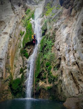
Alamar
| Rating: | ||||||||||||
|---|---|---|---|---|---|---|---|---|---|---|---|---|
| | Raps:3-6, max ↨98ft
Red Tape: Shuttle:Optional 10 minutes (2 miles) | |||||||||||
| Location: | ||||||||||||
| Condition Reports: | 25 Oct 2021
"Its a pretty drainage but the canyon parts are underwhelming for the amount of hiking and creek-walking necessary. 3mm wetsuit with jacket was plenty |
|||||||||||
| Best season: | ||||||||||||
| Regions: | ||||||||||||
Introduction[edit]
A nice canyon right next to Huaponal. It is fairly easy to do both in the same day with a relatively strong, fast group.
The road to this canyon is paved all the way except for the last 5 miles that are gravel, and are passable with a passenger vehicle. It is about a 3hr drive each way from Monterrey.
This canyon is a bit cooler than Huaponal with more swimming, and while you likely won't need wetsuits for that one, you will want them for this one.
The gps tracks and description are for the lower part of the canyon. There is another upper part of the canyon (not described here), which is another 5 rappels up to 90m high. However the start for the upper section is a 2 hour drive further up the road from this lower part. The upper part is typically done by hiring a driver from one of the houses in the tiny hamlet at the end of the two canyons. He will ride with you to the start of the upper, drop you off, and drive your vehicle back to the end for it to be waiting for you.
Approach[edit]
Shuttle with a vehicle or hike up the road, and then follow the gps track along a well-used cattle path up and over the saddle to the start.
Descent[edit]
There are 3 rappels of 30m, 15m, and 30m. Mixed amongst these are an additional 3 short "nuisance" rappels, although all of them are downclimbable.
Exit[edit]
At the base of the 3rd (30m) rappel, there is a large watering trough and a well established dirt water sluice that leads back to the hamlet. You can either continue down the canyon drainage, or hike out along this sluice which goes high above the canyon below and is a rather novel way to exit.
Red tape[edit]
It's a good idea to check in at one of the houses and tell them what you're doing there, and they will likely store your vehicle and/or drive it back down from the shuttle. As of Oct. 2021, they charged us 260 pesos for this service and then offered to let us camp for free on their property.
Trip reports and media[edit]
 Wikiloc.com : Cañón de Alamar
https://www.youtube.com/watch?v=XhOhdOdmBMM
