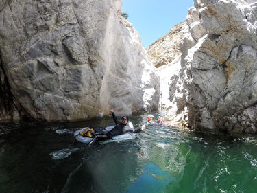
Arroyo Seco Gorge (Big Sur)
| Rating: | |||||||||||||||||||||||||||||||
|---|---|---|---|---|---|---|---|---|---|---|---|---|---|---|---|---|---|---|---|---|---|---|---|---|---|---|---|---|---|---|---|
| | Difficulty:2B III (v1a2 III) Raps:0 if going to the 1st waterfall
Red Tape:No permit required Shuttle: | ||||||||||||||||||||||||||||||
| Location: | |||||||||||||||||||||||||||||||
| Condition Reports: | 27 Aug 2023
"Most of the park is closed including the two roads that would make this accessible possibly reopening arroyo seco rd after the 31st of this month |
||||||||||||||||||||||||||||||
| Best season: | Anytime (avg for this region)
|
||||||||||||||||||||||||||||||
| Regions: | |||||||||||||||||||||||||||||||
Introduction[edit]
This can be done in two different ways at least. The best section is the last 4 miles.
One way multi-day backpacking trip from TOP[edit]
Point to point. Hence need a long car shuttle
01 Start : Escondido Campground : 36.141370, -121.494927
02 Horse Bridge : 36.218807, -121.502359
03 Trash Can Exit : 36.222232, -121.496468 (A trail to exit / enter the creek from the trail. There are 2-3 Trash cans here on the trail as a marker)
04 Takeout Parking (Arroyo Seco Campground) : 36.234268, -121.487986 (there is a closed gate here, porta potty, tap water, need backpacking parking permit. $10 - pay the gate entrance)
05 Arroyo seco campground entrance Gate : 47656 Forest Route 19S09, Greenfield, CA 93927
One day trip Out and back from the BOTTOM[edit]
Enter park at 05, Pay for entrance and parking.
Drive till 04 and park there.
Start hiking.
Hike till 02.
There is a trail to your right that goes to the creek bed. While on this trail you will see the bridge but do not cross the bridge. Just continue the trail to creek bed. Then follow the creek upstream.
Approx 1 mile to the first waterfall (36.208475, -121.499095).
Note that just before the waterfall, there is continuous floating required through the narrow section for about 300 - 400 ft. So, flotation device is must.
There are ropes to climb up the waterfall.
After spending some time above the waterfall, follow the same route back to the car.
Approach[edit]
The entry Kiosk staff will give you a parking permit for day use and directions to the day use for hiking the Gorge. Day Parking is $10 or a $50 annual pass. With a National Park Pass discount it was $5 as they said they are concessionaires. Campsites are also available. The parking area has 2 pit toilets and a picnic table. Once the parking is full, they don't allow additional cars in or walk ins; there's no "one in, one out" policy.
Hike past the gate which will turn to a wide dirt fire road. The 2.5 mile hike will have views of the green tinted river below and surrounding mountain ranges. There will be a 20ft length small bridge about 20 minutes in to the left that has a nice view of a smaller side creek. Cross it and keep on the trail. Keep hiking for another 30 minutes to the large dirt parking lot with a forest sign that takes you down a developed trail to the water. The very long 60ft length horse bridge is the marking point to leave the trail and into the water course. There are campsites at the sandy base of the bridge as well. Options for putting on the wetsuit: it could be at the bridge or scramble for another 15 minutes on the edges of the water to the first field long deep pool swimmer.
Descent[edit]
- If done during the summer, the water flow is reduced below than 2cf and can be considered a "B".
- If done during wet season, there may be higher water flow above 10cf that will create hydraulics and maybe considered a "C" swift water. The waterfall described above may not be ascended during higher flow and approaching the waterfall will pull a person in the wrong direction to be trapped on the other side (RDC pool). The campground host can be called to see if they know the condition.
Exit[edit]
Possible exits after turning around at the waterfall and going back down stream: it is a good idea to spot these trail exit options on the hike in so you know what the options are and how the shore looks below.
- Horse Bridge per the above drop in.
- Sandy Beach down river of the Horse Bridge with a silty trail going up to the right
- Rock shore down river of the sandy beach with a silty trail to the right going up that eventually turns into a walk through the meadow
- Campground & Parking
Red tape[edit]
Floatation device needed for long swims and very deep water sections.
Beta sites[edit]
Trip reports and media[edit]
Background[edit]
- The Ventana wilderness has limited seasonal access
- Monterey Ranger District: (831) 385-5434
- Rockymountainrec.com, 47600 Arroyo Seco Rd, Greenfield, CA 93927, (831) 674-5726

