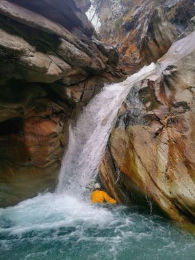
Baltschieder (Lower)
| Rating: | |||||||||||||||||||||||||||||||
|---|---|---|---|---|---|---|---|---|---|---|---|---|---|---|---|---|---|---|---|---|---|---|---|---|---|---|---|---|---|---|---|
| | Raps:4 + 2 Jumps, max ↨66ft
Red Tape: Shuttle:None Rock type:Gneiss | ||||||||||||||||||||||||||||||
| Start: | |||||||||||||||||||||||||||||||
| Parking: | |||||||||||||||||||||||||||||||
| Condition Reports: | |||||||||||||||||||||||||||||||
| Best season: | Autumn
|
||||||||||||||||||||||||||||||
| Regions: | |||||||||||||||||||||||||||||||
Introduction[edit]
Another big valley that has bad rock that doesn't allow a nice canyon. If you try it, better get out at the Train Bridge, afterwards there are only blocks.
Approach[edit]
Take the hiking path leading into the valley (on the western side). At the first opportunity to cross the river, you can see the "main section" from the bridge. But you'll need to stay on the same side and then take the path that goes towards the next smaller bridge. There it is easy to reach the water.
Descent[edit]
A few jumps to start off (not very deep), then around 3-4 technical rappels. And then just boulders, better find a way out if you don't want to spend your time downclimbing.
Exit[edit]
If you stay in the riverbed, on top of the boulders you'll need to cross a construction area (at least in 2021). So it's definitely better to find a way back to the hiking path way up already.
Red tape[edit]
Beta sites[edit]
Trip reports and media[edit]
Background[edit]
First descent in november 2021. Second descent predicted in november 2047.
