Banana Slog Canyon
| Rating: | |||||||||||||||||||||||||||||||
|---|---|---|---|---|---|---|---|---|---|---|---|---|---|---|---|---|---|---|---|---|---|---|---|---|---|---|---|---|---|---|---|
| | Difficulty:3B II (v3a2 II) Raps:3-5, max ↨60ft
Red Tape: Shuttle:None Rock type:Sandstone | ||||||||||||||||||||||||||||||
| Start: | |||||||||||||||||||||||||||||||
| Parking: | |||||||||||||||||||||||||||||||
| Condition Reports: | 1 Dec 2024
"Nice short canyon nearby to the Bay. Basically no water despite the week of rain end the previous ~ Wednesday. Bushwhacking was not too bad. A little |
||||||||||||||||||||||||||||||
| Best season: | Winter and Spring (avg for this region)
|
||||||||||||||||||||||||||||||
| Regions: | |||||||||||||||||||||||||||||||
Introduction[edit]
Named for its resident Banana slugs and required bushwhacking for approach and exit, Banana Slog Canyon is a fun little creek in Castle Rock State Park. A good canyon in the area to practice ghosting techniques.
This creek had a pleasant, splashy flow in May 2023 after one of the wettest winters on record in the Bay Area. The “high” flow made it a canyon worth doing - in normal years, we would expect flow to be trickling at best.
Approach[edit]
Park on the side of Highway 35 by the Los Altos Rod & Gun Club Range. Hike down the Service Road Trail (or Loghry Woods Trail if you want a scenery change), towards Castle Rock Trail Camp until you reach Frog Flat Camp. From this point on there are no more trails. Look for a break in the thick vegetation and follow the direction of the creek. We found a spot that was not too bad just past campsite 5. Bushwhack down a steep hill and then a gully until you meet the creek. I’d recommend sticking close to the GPS track because the other gullies look a lot steeper.
Descent[edit]
After reaching the creek, there is a spot with a small pool and some rocks to suit up if need be.
R1: 40ft drop, good tree about 15ft back.
A fairly lengthy and steep creek walk separates the first rap from the lower technical section.
Lower technical section (R2-R5): There are many anchor options for these lower raps and you may not have an escape route until R4.
At some point you get to a little slide. Be careful in stronger flows because R2 is right after this slide.
R2: 20ft slanted drop after a section of exposed rock.
R3: 25ft vertical drop immediately after R2.
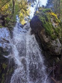
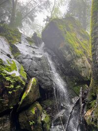
R4: The main falls. 60ft. 150ft rope double stranded around the larger tree RDC was barely enough. There are some other options of anchors too.
R5: Optional 15ft rap just after the big one.
Exit[edit]
Bushwhack up the hill DCL back to the drop in point and follow the approach bushwhack back to the campsite. Don’t go up the other side of the creek (DCL) all the way because that would lead you to a closed nature restoration area.
Red tape[edit]
There are a few turnouts off of the main road that can be used for parking. To avoid being constrained on timing, avoid parking in the park's gated areas, gates will close when the park closes.


