Bois Malaise
| Rating: | |||||||||||||||||||||||||||||||
|---|---|---|---|---|---|---|---|---|---|---|---|---|---|---|---|---|---|---|---|---|---|---|---|---|---|---|---|---|---|---|---|
| | Raps:5, max ↨98ft
Red Tape: Shuttle:Required 4 km | ||||||||||||||||||||||||||||||
| Location: | |||||||||||||||||||||||||||||||
| Condition Reports: | |||||||||||||||||||||||||||||||
| Best season: | Anytime
|
||||||||||||||||||||||||||||||
| Regions: | |||||||||||||||||||||||||||||||
Introduction[edit]
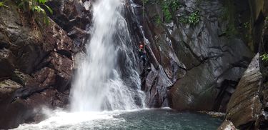
The highest rated canyon to date in Guadeloupe for good reason. The first rappel is certainly the most photogenic, with a sheer wall descending into a long waterfall. There are 5 more rappels in this canyon, a toboggan and a few small jumps.
Approach[edit]
From the town of Basse-Terre on the western half of the island of Guadeloupe, follow the coastal road (N 2) 22 km (from the Basse-Terre airfield) northwards (through the villages of Vieux-Habitants, Bouillante) until we reach the town of Pigeon. At the outskirts of Pigeon we cross the Rivière (= river) Bourceau. About 380 m further on the N 2 we turn right towards Birloton. After 750 m (from the N2) branches the road.We first drive left here and come after 1100 m, finally steeply down to the river Lostau (in which further flows above the Bois Malaisé). Here once a bridge spanned the river (destroyed by a cyclone). There we leave the car for the exit. There are enough spaces for 3 or 4 cars at this river, and be aware the road is very steep, so we actually had to have all passengers exit our small rental car and give it a push to make it up the hills. With the other car, the 1100 m back to the road junction and here then in a sharp angle left (road to the settlement Négresse and direction Birloton). After about 2 km (from the road junction) this road ends and we turn off the car for the approach (Same car park as for the Canyon Bourceau, altitude 290 m above sea level). From the parking area Bois Malaise shares with Bourceau, you take the trail on the left at the end of the road (the trail on the right is to Bourceau). Once on the trail continue following the narrow footpath to the drop in point. It will descend very steeply on the left into a small drainage. The first rappel is exactly where you meet the watercourse.
Descent[edit]
From the end of the road we take the path on the left and follow the signpost 'Piton de Bouillante'. The path climbs, partly steeply, about 170 m up to the height 460 m above sea level. Here he branches. We take the left path (almost straight ahead) following the signpost 'Piton de Bouillante par l'Esperance'. The path no longer moves so steeply, crosses a brook bed and about 30 minutes after the path branching opens us a clear view to the north of the woods. About 5 minutes further goes down the left as such hardly recognizable path to the entry. The branch was marked in 2013 with a cord loop li. on a tree at about 2 m height (see photo). We are here about 510 m above sea level. If we should have reached the border of the National Pak (sign), we have already gone too far and have to go back about 130 m. The tracks lead us now steeply down (in doubt, rather on the right hold on the back) in an orograf. The left side stream of the Bois Malaisé, about 20 m (and a 25 m abseiler) above its mouth in the Bois Malaisé. (01h 00 ')
Exit[edit]
After the 5th and last abseiler (the accession ropeway from the side stream in the Bois Malaisé included) we walk and climb for about 30 minutes further downriver. Then the river Losteau flows in from the right (altitude 135 m above sea level). Continue down the riverbed for about 50 meters and then turn right up the bank to a path that runs down the river towards the lower parking area. The path parallels the river on the right bank as you head downstream. You will pass 2 old homesteads on your way down, one is fenced and may have a guard dog present. After about 20 minutes and the final crossing of the river Losteau we have reached this. (00h 20 ')
Red tape[edit]
Beta sites[edit]
 Descente-Canyon.com : Bois-Malaisé
 Canyon.Carto.net : Rivière Bois Malaisé
 An Kanion La-madinina : Rivière Bois Malaisé
 An Kanion La-madinina : Rivière Bois Malaisé [G-2]
