Boulder Creek (North Cascades) Canyoneering Canyoning Caving descenso de barrancos Barranquismo
The exploration of this location has not yet been documented
All information is unverified estimation |
|---|
|
| Rating: |
Log in to rateLog in to rateLog in to rateLog in to rateLog in to rate 0.0 (0 ratings) |
|
|
| |
Raps: No Shuttle:None |
|---|
| Location: |
|
|---|
| |
|---|
| Condition Reports: |
(log in to submit report)
|
|---|
Weather: |
|
|---|
| Best season: |
Summer, Fall (avg for this region) | winter | | spring | | summer | | fall |
|---|
| Dec | Jan | Feb | | Mar | Apr | May | | Jun | Jul | Aug | | Sep | Oct | Nov |
|
| Regions: |
|
http://aaronswaterfallworld.tripod.com/bouldercreekfallsbaker.htm
48.7398, -121.7412https://ropewiki.com/images/a/aa/Boulder_Creek_%28North_Cascades%29.kmltopo
GPS data automatically extracted from [], please visit their site for more detailed information.
Automatic GPS data extraction NOT allowed, please visit [] to download GPX.
Reference photos
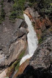
4 Sep 2014:
Very High. Dangerously high water, only for expert swift water canyoneers (class C3 = a6). Photo: Aaron Young
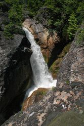
12 Jul 2009:
Extreme. Extremely dangerous high water, may be unsafe even for experts (class C4 = a7). Photo: Aaron Young
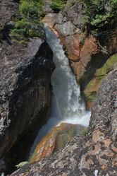
12 Aug 2013:
Extreme. Extremely dangerous high water, may be unsafe even for experts (class C4 = a7). Photo: Aaron Young
These reference pictures are used in the
Waterflow analysis to predict current conditions. More reference pictures will produce a more reliable prediction.
(log in to submit reference picture) | Welcome! Canyons in the Pacific Northwest can be different from those you might be used to. Be ready for unlinked bolts, retrievable traverse lines, and challenging aquatic environments. For more on local practices, and the best way to get started in the region, check out the WCC Safety page.
- Unlinked Bolts - groups should be comfortable rigging unlinked bolts, either temporarily linking them for all but the last person, or using a passive redundancy method. Most importantly, if you find two bolts side by side that are unlinked, do not add webbing to them. Linking bolts designed to be unlinked will likely cause damage during seasonal floods.
- Traverse Lines - many canyons are rigged to allow traverse line access to an exposed anchor station. This should be done using self-belay or team belay techniques. Do not leave fixed lines in the canyons.
- Challenging Environments - the highly aquatic nature of PNW canyons can surprise many. Cold temperatures, slippery rocks, loud waterfalls, and strong currents all lead to unexpected problems. Do not underestimate the need for strong team work and technical proficiency. Belays are frequently not possible. Unattended gear will sink or float away. Sliding and jumping is the cause of most major injuries, so it's critical to effectively communicating water depth & submerged hazards.
|
Introduction
Boulder Creek is located within Mount Baker Wilderness, Mount Baker-Snoqualmie National Forest in Whatcom County, Washington. It is a tributary of the Baker River (confluence at Baker Lake), and its source is the Boulder Glacier on the southeast slope of Mount Baker. Due to its elevation (2,467 ft, 752 m), glacial source, and formidable features, it is unknown if there will ever be a time when it is within the realm of possibility to descend this canyon. But if there is, Boulder Creek Falls contains a short canyon which is sure to test the abilities (and luck) of the most skilled swift water canyoners.
Waterflow
Since Boulder Creek is a glacial stream, sourced by a glacier on a southeast aspect, it may be the case that the waterflow level will be lowest in periods of relatively less sunlight, colder temperatures, and less precipitation/snow melt - perhaps in the fall. This season also presents disadvantages, such as shorter days, colder air temperatures, and unpredictable weather.
Approach
Descent
Exit
Red tape
Beta sites
Young, Aaron. "Boulder Creek Falls". Aaron's Waterfall World. Retrieved 6 March 2016.
Trip reports and media
Background
Aaron Young scouted and documented Boulder Creek Falls, visiting on at least three occasions (2009, 2013, and 2014). On 5 February 2015, he made a suggestion on the Pacific North-West Canyoning Facebook group that Boulder Creek may be of interest to canyoners, and he provided photos and other information.[1]
References
-20160306061755_pic.jpg)
-20160306060853_pic.jpg)
-20160306061421_pic.jpg)
_Banner.jpg)