Budweiser Creek
| Rating: | |||||||||||||||||||||||||||||||
|---|---|---|---|---|---|---|---|---|---|---|---|---|---|---|---|---|---|---|---|---|---|---|---|---|---|---|---|---|---|---|---|
| | Raps:4
Red Tape:No permit required Shuttle:Optional | ||||||||||||||||||||||||||||||
| Location: | |||||||||||||||||||||||||||||||
| Condition Reports: | |||||||||||||||||||||||||||||||
| Best season: | Apr-June
|
||||||||||||||||||||||||||||||
| Regions: | |||||||||||||||||||||||||||||||
Introduction[edit]
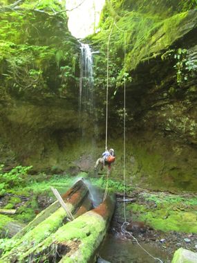
Budweiser Creek would be a delight if it were not for the fact that some timber company went through the drainage like a pack of crazed voracious beavers. The drainage, when visited in 2016, was just a mess of cut logs and blowdown. The rappels are all great -- with the unusual note that all four are overhanging - but reaching them requires substantial effort. Come in the early season if you must... as the flow reduces substantially heading into early summer. Like the beer of the same name, why not try something else?
- Budweiser is currently a contender for worst creek in the PNW.
Approach[edit]
This area is a maze of logging roads. Map and GPS may be handy. Roads are gravel but 2WD-friendly if driven slowly. High clearance may be nice.
Lower Parking[edit]
From Bridge of the Gods, follow Hwy 14 east for 1.6mi. Turn left on SW Rock Creek Dr (signed for Skamania Lodge) and follow for 0.3mi before turning left onto Foster Creek Rd. FCR becomes Ryan-Allen Rd; follow for 0.9mi. Under a set of powerlines, turn left onto Red Bluff Rd. Red Bluff quickly becomes a good gravel road; follow it northwest for 2.5mi, before turning right on CG 2330. The road drops down to a bridge crossing Rock Creek in 0.3mi. On the far side, stay on CG 2330 as it climbs out of the drainage. Follow this windy road for 2.8mi to a prominent junction about UTM 10 582576mE 5067254mN. From the junction continue on CG2330 for 100yrds before bearing left on an unnamed gravel road diverting to the northwest. Follow for 0.75mi to a large pullout just before the road swings north into the Budweiser drainage. Pullout is at about UTM 10 582238mE 5067788mN.
Upper Parking[edit]
Drive back out to CG 2330 and head north about 1mi, passing a prominent junction along the way. Your goal is to reach the spot where the road crosses Budweiser Creek. There is room off the road here for several vehicles.
Descent[edit]
Be prepared to get your thrash on as you drop into the creek per clambering over, under around, and through various obstructions and logjams. In some place it's easier to exit the creek entirely and re-enter downstream. The drainage is filled with huge fallen trees... so many were cut and left to rot in the drainage one is forced to wonder just how competent the loggers were in these parts. If you're not going to haul out the trees, why cut them?
The first rappel is 2min from the road.
- R1: 40ft.
- R2: 60ft. Watch for a dead snag DCL near the top. Located 5min downstream from R1.
Expect a long thrash between R2 and R3. It's long enough to start having thoughts along the lines of: Has my life really led me to this point? Where did it all go wrong? Topo maps show an old logging grade crossing the creek which might be a viable early exit, but it's not obvious where the crossing is when you're in the creek.
- R3: 40ft. Climb down through a neat mini-narrows with cool layered bedrock and climb out on a ledge DCL to a tree that looks like it was placed here specifically for canyoneers. Watch your landing between two old growth logs. A magical spot in the destruction that is Budweiser Creek.
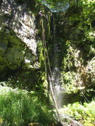
- R4: 50ft. Use caution in getting on the rap; easy to have a minor pendulum per the shape of the falls.
Exit[edit]
Map and GPS highly recommended to escape Budweiser. There are cliffs above R4, so head downstream a hundred yards or so before exiting the drainage DCL. Thrash up wherever is easiest and round the nose of the ridge, separating Budweiser from a tributary stream. We found a well-trodden series of game trails and followed them upwards. Beware poison oak in open areas through here... which just makes this creek even more special. We reach the bottom of a steep cliffy area and traversed east, continuing on game trails until the terrain moderated enough to get up on the ridge. Follow the ridge upwards until you intersect the good logging road running along the drainage around 1850' and your waiting shuttle car. At last... the nightmare is over!
Red tape[edit]
None.
Beta sites[edit]
Trip reports and media[edit]
Background[edit]
We ran Budweiser so you don't have to. :)

