Cetina
| Rating: | |||||||||||||||||||||||||||||||
|---|---|---|---|---|---|---|---|---|---|---|---|---|---|---|---|---|---|---|---|---|---|---|---|---|---|---|---|---|---|---|---|
| | Raps:max ↨66ft
Red Tape: Shuttle: Rock type:Limestone | ||||||||||||||||||||||||||||||
| Location: | |||||||||||||||||||||||||||||||
| Condition Reports: | |||||||||||||||||||||||||||||||
| Best season: | DIFFICULT in Anytime
|
||||||||||||||||||||||||||||||
| Regions: | |||||||||||||||||||||||||||||||
Introduction[edit]
This is a fun canyon. During August of 2018 we combined it with a packraft trip from the town of Blato n/c. Logistics of the transition still need to be ironed out before this combo trip can go mainstream.
Approach[edit]
From Zadvarje, take Ulica Mala Mlinica. This is where guide services drop off their guides and clients, I understand you can leave a car here. Look for a pronounced trail down into the canyon, which will begin to your left if you are facing the end of the road.
Descent[edit]
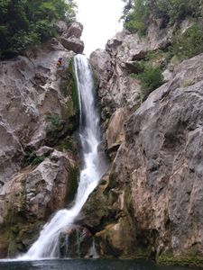
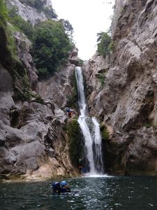
We did the first and largest rappel on questionable bolts DCR. There is a small pool just above the large waterfall, and the water can have power here too - a belay is most prudent for the first to the anchors, again DCR just above the waterfall.
Anchors for the second rappel were also iffy, but there were more of them. They are easily visible DCR shortly after swimming the pool at the bottom of the 1st rappel.
I understand there were additional optional jumps/rappels, but we bypassed these by trail on the canyon's left (DCL). Our combo trip was running longer than planned and we were running out of daylight.
Exit[edit]
Without light, we struggled to find a reliable exit and bushwhacked up and left out of the canyon, and then followed an aqueduct to a bridge. Doable but not advised. Because commercial trips are being done in this canyon, look for a better exit with daylight.
Red tape[edit]
Climbing on or around the dam is forbidden.
On the day we were there, the villagers in Nejasnici were most unhelpful so far as help scrambling/bushwhacking/routefinding from the traditional whitewater exit to the canyon put in.
Beta sites[edit]
 Descente-Canyon.com : Cetina
Trip reports and media[edit]
 Wikiloc.com : Cetina: Kanjoning


