Chärstelenbach
| Rating: | |||||||||||||||||||||||||||||||
|---|---|---|---|---|---|---|---|---|---|---|---|---|---|---|---|---|---|---|---|---|---|---|---|---|---|---|---|---|---|---|---|
| | Raps:18, max ↨115ft
Red Tape: Shuttle:None Rock type:Limestone and Gneiss | ||||||||||||||||||||||||||||||
| Start: | |||||||||||||||||||||||||||||||
| Parking: | |||||||||||||||||||||||||||||||
| Condition Reports: | |||||||||||||||||||||||||||||||
| Best season: | Autumn
|
||||||||||||||||||||||||||||||
| Regions: | |||||||||||||||||||||||||||||||
Introduction[edit]
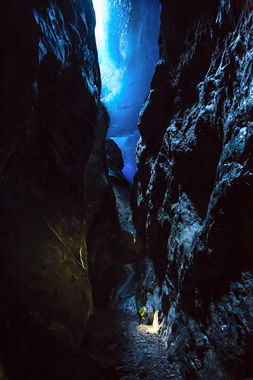
As the Glacier is shrinking, this insane canyon became more and more visible. Made of two parts, with the first one still below the glacier, this descent is one of the most technical of the alps in terms of combining mountain activities, as the approach is made on the glacier itself.
Approach[edit]
The parking is far away, there is an alpine taxi though which can get you up, but even from there it is still a long way to the Hüfihütte. There are already some rappels to do, in aim to reach the glacier. Once you've crossed that one, you'll need to find a spot where it is possible to abseil below the ice to the start of the canyon.
Descent[edit]
First rappels are still below the glacier, then it gets completely dark before being spit out on a 30m Waterfall. There is about one km to walk until you'll reach the last section of this canyon, where another narrow part with 7 rappels awaits you.
Exit[edit]
Follow the river until you reach a hiking path.
Red tape[edit]
Beta sites[edit]
Trip reports and media[edit]
Picture credit : Matthias Holzinger
