Chuveje
| Rating: | |||||||||||||||||||||||||||||||
|---|---|---|---|---|---|---|---|---|---|---|---|---|---|---|---|---|---|---|---|---|---|---|---|---|---|---|---|---|---|---|---|
|
| |||||||||||||||||||||||||||||||
| | Raps:15, max ↨131ft
Red Tape:Access is Restricted Shuttle:Required Yes Rock type:Limestone | ||||||||||||||||||||||||||||||
| Location: | |||||||||||||||||||||||||||||||
| Condition Reports: | |||||||||||||||||||||||||||||||
| Best season: | Nov - May
|
||||||||||||||||||||||||||||||
| Regions: | |||||||||||||||||||||||||||||||

Introduction
Update March 23, 2023: I was told by an older gentlemen that seemed to be in charge at the entrance station to the waterfall at the bottom that the ENTIRE DRAINAGE is off limits. Perhaps he was perturbed by the idea of people going into the drainage, but he did not agree that only the final rappel(s) were off limits. I believe he used the word "sagrado" (sacred), but I spaced off for a second and didn't ask for clarification after.
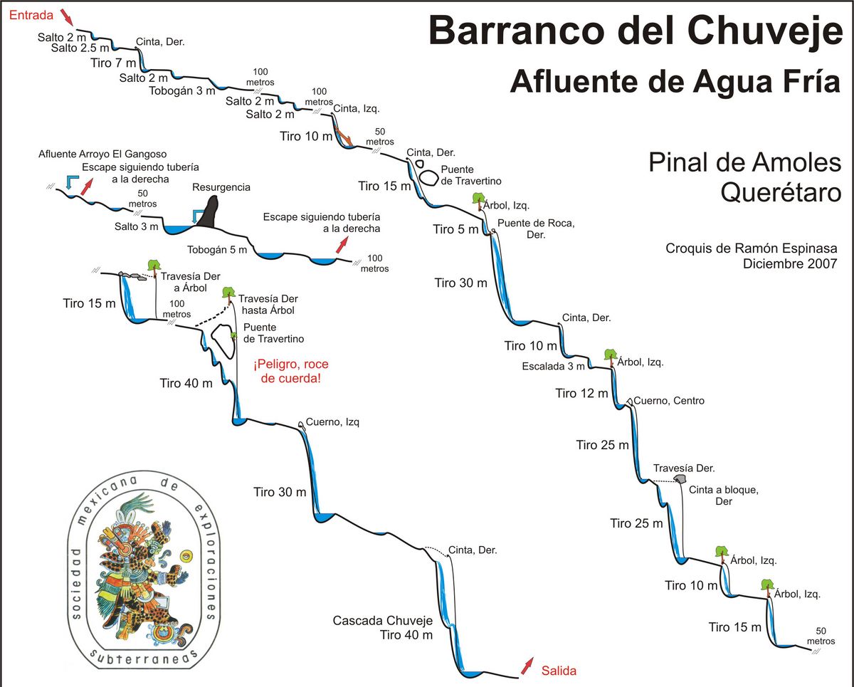
Rappelling is prohibited on the final waterfall sequence in this canyon, due to the tourist attraction at the bottom. However there is still much canyon upstream of this sequence, and there is a bailout RDC just above it. It might be possible to do the upper part of the canyon and bail at that point. On the side profile it is indicate by "Escape siguiendo tuberia a la derecha", or "Escape following the tubing on the right".
A local canyoneer named Odysseus Hex Mex, very knowledgeable in the area, has said that he does not think it would be worth doing just the upper section, because the escape path is long and you'll miss the best rappels. The hillsides in the area are indeed very steep, so the exit path is unknown. If your group was to attempt it, he says "to escape Chuveje, the 2nd exit is the one you must take, go up to the right following the tube, until you reach a stone wall, follow it down to take you to the Chuveje park".
If you were to do the final rappel sequence, he writes "the last rappel in Chuveje is prohibited, maybe they will not do anything to the people they see going down, but the consequences would be that they would be more strict on who enters the mountains, and we could have problems and lose access to other canyons".
Approach
Desde Pinal de Amoles tomar la carretera a Jalpan y en Huazquilico tomar la terracería a la derecha rumbo a San Pedro Escanela. A los dos kilómetros se cruza el arroyo Agua Fría, que debe seguirse río abajo hasta los primeros saltos.
Descent
Hermosísimo barranco con un total de 15 cascadas y al menos 10 saltos o toboganes.
Exit
Al bajar la última cascada (Cascada del Chuveje) seguir la vereda del parque hasta el estacionamiento.
Red tape
Beta sites
 Cañonismo.com : Chuveje
Trip reports and media
 Wikiloc.com : Barranco del Chuveje
Background
El primer descenso conocido fue realizado por miembros de la Sociedad Mexicana de Exploraciones Subterráneas (Ramón Espinasa, Ruth Diamant, Chris Lloyd, Gustavo Vela y Ana Elisa García) en diciembre de 2007