Clusa
| Rating: | |||||||||||||||||||||||||||||||
|---|---|---|---|---|---|---|---|---|---|---|---|---|---|---|---|---|---|---|---|---|---|---|---|---|---|---|---|---|---|---|---|
| | Raps:40, max ↨131ft
Red Tape:Permit required Shuttle:None Rock type:Limestone | ||||||||||||||||||||||||||||||
| Start: | |||||||||||||||||||||||||||||||
| Parking: | |||||||||||||||||||||||||||||||
| Condition Reports: | |||||||||||||||||||||||||||||||
| Best season: | Jul-Sep
|
||||||||||||||||||||||||||||||
| Regions: | |||||||||||||||||||||||||||||||
Introduction[edit]
This description is for Val Clusa Intermedio and Inferior
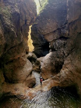
Hard and wild, most book authors claim this is the best canyon in the region. However, the canyon looses a lot of its appeal if you run it after major storms, the water is often muddy for days and it's too risky to do many of the slides and jumps the canyon has.
Approach[edit]
From the car park, take the GR 546 that leads to Val Clusa. The path climbs quickly and after 30 minutes you will find the access road to the dam that descends to the right (Val clusa inferior).
Continue climbing up to an altitude of 962m. Do not take the path on the left, but start to descend slowly until you reach the stream of Val Polidoro. To enter here, go down the stream until you find the first anchor on a tree.
To access the upper entry to Intermedio, follow the path andcontinue ascending more or less parallel to the ravine until the path crosses it.
Descent[edit]
It is almost impossible to escape once you enter the canyon. Escape between the intermediate and lower section.
A large number of waterfalls that follow one another without stopping. The canyon is divided into four parts: The 1st part is made up of beautiful more or less formed waterfalls.
Facing the tributary of the Val del Pezz, is the most aesthetic part. The ravine closes with very pure lines and prominent colors.
The most beautiful waterfall is 35 meters high, forming a beautiful slide that ends in a spider thread. The part between this waterfall and the dam also has a radically different eerie vibe. The water level increases by up to three times at the confluence with the Pez river. The stream forms a long corridor of an original color.
The last part starts under the dam. Be careful when you start seeing RG or even RD signs that you are near the outlet. Do not descend behind the dam wall if the dam is empty - you'll be stuck!
Exit[edit]
Go out to the main river and go up it until you reach the bridge that crosses the river to access the car park.
Red tape[edit]
Beta sites[edit]
 Descente-Canyon.com : Clusa
 Canyon.Carto.net : Val Clusa
 CicaRudeClan.com : Val Clusa
 Altisud.com : Val clusa inferieur
 Altisud.com : Val Clusa Supérieur
 Catastoforre AIC-Canyoning.it : Val Clusa
 Canyoning in the Alps Book by Simon Flower : Clusa (Lower)
 Canyoning in the Alps Book by Simon Flower : Clusa (Upper)
 Canyoning Nord Italia Book by Pascal van Duin : Clusa
 Gulliver.it : VAL CLUSA
 TNTcanyoning.it : Val Clusa
Trip reports and media[edit]
![]() Barranquistas.es : VAL CLUSA
Barranquistas.es : VAL CLUSA
