Cormor
| Rating: | |||||||||||||||||||||||||||||||
|---|---|---|---|---|---|---|---|---|---|---|---|---|---|---|---|---|---|---|---|---|---|---|---|---|---|---|---|---|---|---|---|
| | Difficulty:4B III (v4a2 V) Raps:20, max ↨89ft
Red Tape: Shuttle:Required 7.0km | ||||||||||||||||||||||||||||||
| Location: | |||||||||||||||||||||||||||||||
| Condition Reports: | |||||||||||||||||||||||||||||||
| Best season: | Jun-Oct
|
||||||||||||||||||||||||||||||
| Regions: | |||||||||||||||||||||||||||||||
Introduction[edit]
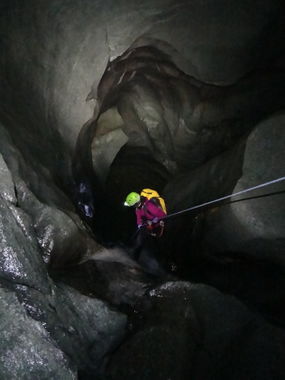
Access from: Field Franscia Longest abseil height: 30 meters Information of the flow: beware of flow levels. Only a little water is safe. Necessary material: 2 x 30 meters Neoprene: Yes Installation material: Advisable to carry spare installation material Observations: Dam at top may release, tlf: 0342451260, or ask in the bars that usually know the releases Approach time: 5 minutes Time of descent: 4 hours Schedule of return: 30 minutes Starting height: 1900 m Height at the end: 1550 m Length: 1100 meters Slope: 350 meters Character: Spectacular ravine under a detachment, two areas completely dark where headlamps are necessary. Absolutely run if you are in the area!
Approach[edit]
Desde Milan direccion Sondrio-Colico, coger la SS38 hasta Sondrio y de aqui hacia Valmalenco. Subir y poco antes de Chiesa Valmalenco girar hacia Lanzada. Atravesar el pueblo y segir hacia Campo Franscia, al llegar a este aparcamos el primer coche en alguno de los parking. Con el otro coche subimos hacia el embalse de Campo Moro, casi en la presa enfrente de un parking sale una pista a la izquierda que baja hacia la presa, en una explanada dejar el segundo coche. Bajar andando hasta el cauce y seguir hasta encontrar los primeros rapeles aun con luz.
Use a shuttle of cars. It is 7 kilometers from Campo Franscia to the Campo Moro dam
From Milan direction Sondrio-Colico, take the SS38 to Sondrio and from here to Valmalenco. Go up and shortly before Chiesa Valmalenco turn towards Lanzada. Cross the village and go towards Campo Franscia, when arriving at this we park the first car in one of the parking lots. With the other car we went up to the reservoir of Campo Moro, almost on the dam in front of a parking lot, there is a track on the left that goes down towards the dam, in an esplanade leave the second car. Walk down to the riverbed and continue until you find the first rappel.
Descent[edit]
El barranco es un antiguo desprendimiento, consta de dos zonas oscuras, con rapeles, zonas estrechas, y todo en un gran ambiente, de repente te sumerges casi sin querer en la oscuridad. Imprescindible iluminación artificial. Todo muy bien equipado.
The ravine is an old detachment, consists of two dark areas, with rappels, narrow areas, and all in a great environment, suddenly you dive almost without wanting to in the dark. You MUST have good headlamps!. All anchors (bolts) very well equipped.
Exit[edit]
Despues del rapel de salida, evidente, seguimos la senda rio abajo ( izq. orografica) hasta cruzar el rio cerca de unas señales de peligro. Seguir la senda ahora por este lado del rio,( derc. orografica) siempre pegada a este, hasta llegar al pueblo.
After the exit rappel, obviously, follow the path down the river (left orographic) until crossing the river near some danger signs. Follow the path now on this side of the river, (orographic slope) always stuck to this, until you reach the town.
Red tape[edit]
Be aware of the dam and water releases. Call 0342451260 or check in the local village.
Beta sites[edit]
 Descente-Canyon.com : Cormor
 canyon.carto.net : Cormor
 CicaRudeClan.com : Torrente Cormor
 Barranquismo.net : Cormor- Lanterna
 Catastoforre AIC-Canyoning.it : Torrente Cormor
 Canyoning in the Alps Book by Simon Flower : Cormor
 Canyoning Nord Italia Book by Pascal van Duin : Cormor
 Gulliver.it : Cormor Speleocanyonig
Trip reports and media[edit]
https://www.christian-balla.de/Cormor
