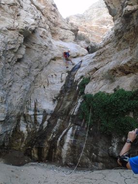
Deep Canyon
| Rating: | |||||||||||||||||||||||||||||||
|---|---|---|---|---|---|---|---|---|---|---|---|---|---|---|---|---|---|---|---|---|---|---|---|---|---|---|---|---|---|---|---|
| | Difficulty:3A III (v3a1 III) Raps:6-7, max ↨160ft
Red Tape:Closed to entry Shuttle:Required 20 min | ||||||||||||||||||||||||||||||
| Location: | |||||||||||||||||||||||||||||||
| Condition Reports: | |||||||||||||||||||||||||||||||
| Best season: | Nov-Mar
|
||||||||||||||||||||||||||||||
| Regions: | |||||||||||||||||||||||||||||||
Introduction[edit]
This is a desert canyon that resembles some of the Death Valley canyons, but is located at the skirts of Mt Sant Jacinto. It is gauged, so you can find out EXACTLY how much water is flowing... In the past (10 years ago) it used to flow strong, but nowadays it rarely exceeds 1/2 cfs, even in spring. In Spring it may have deep pools that can be jumped, in summer all water dries up.
Approach[edit]
Descent[edit]
Exit[edit]
Red tape[edit]
The canyon seems to be entirely on public land according to some maps (see BLM Map) but UC claims ownership of the land where Deep Canyon is located (as shown by the Interactive Map from http://www.ucnrs.org/reserves.html). Moreover, a research center affiliated with UC Riverside (http://deepcanyon.ucnrs.org/about-us/reserve/) is located at the end of the route and strictly limits access to the area from the bottom. There are no fences or signs marking the private property at the top of the canyon, but this land is still UC private property and trespassers may still be cited.
Beta sites[edit]
 Chris Brennen's UNCENSORED BETA : Deep Canyon
 Chris Brennen's Adventure Hikes (Southwest) : Deep Canyon
