Godica
| Rating: | |||||||||||||||||||||||||||||||
|---|---|---|---|---|---|---|---|---|---|---|---|---|---|---|---|---|---|---|---|---|---|---|---|---|---|---|---|---|---|---|---|
|
| |||||||||||||||||||||||||||||||
| | Difficulty:4B II (v4a2 III) Raps:max ↨125ft
Red Tape: Shuttle:None | ||||||||||||||||||||||||||||||
| Location: | |||||||||||||||||||||||||||||||
| Condition Reports: | |||||||||||||||||||||||||||||||
| Best season: | Apr - Oct
|
||||||||||||||||||||||||||||||
| Regions: | |||||||||||||||||||||||||||||||

Introduction
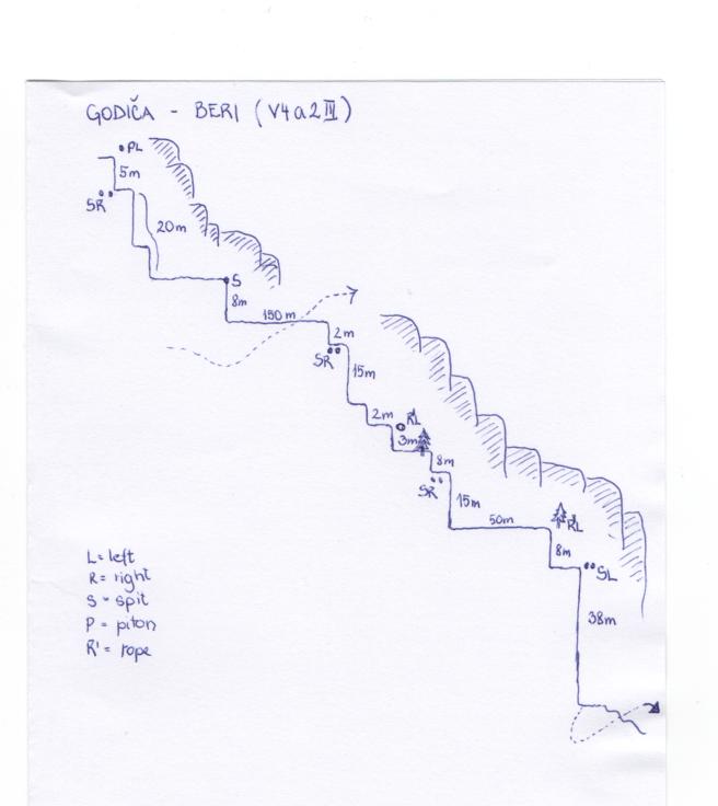
Typical gorge for this part of region (Posočje) with interesting last waterfall (Beri waterfall – 36m). The local name for the canyon is Bezen.
Zone: Primorska – Posočje – Tolmin
Qualities: Entrance: 600 m Exit: 400 m Height: 200 m Length: 800 m
Period April-October
Times: Approach: 1h 20 min Progression: 2h Return: 10 min
Shuttle: No
Equipment: Sufficient
Rope: 2x40m
Possible exit Yes
Maps: Julijske Alpe – zahodni del (1:50.000), Občina Tolmin (1:30.000)
Attraction: Local
Difficulty: V4a2III
Approach
5 km from Tolmin to the village Podljubinj. Park in the village near the bridge for the Beri waterfall (signed).
From the sign for the Beri waterfall cross the bridge and continue for 10 min. Just before the second bridge go uphill (to the right) to the upper part of the rough scree. It is the most tiring part of the way. Just under the rock barrier turn left on the small path and continue till you reach the stream (2 ironcables on the way). Then cross the stream (3rd ironcable) and continue for another 5 minutes, afterwards descend into the canyon (there is no path going down).
Descent
C 5m: one piton with nylon track (L)
C 15m + C 5m: two spits (R)
D 2m
C 8m: one spit (center of the boulder)
150m walking (possible exit)
T 2m
C 15m: 2 spits (R)
C 3m: rope through the hole in the rock (L)
C 6m: tree – unequiped (R)
C 15m: two spits (D)
50 m of walking
C 7 m: tree with rope (L)
C 38 m: two spits with chain (L)
After the last waterfall follow the path starting on the right side of the bank (10 min to the car).
Exit
Red tape
Beta sites
 Canyon.Carto.net : Godica
Trip reports and media


Background
The first descent on 24th of March 2012, Canyoning Cult Slovenia Matic Udir, Robert Zerovec, Grega Maffi, Urska Bricelj). (David Sefaj, Rappeling points are sometimes hard to catch because they are out of the water.