Great White Icicle
| Rating: | |||||||||||||||||||||||||||||||
|---|---|---|---|---|---|---|---|---|---|---|---|---|---|---|---|---|---|---|---|---|---|---|---|---|---|---|---|---|---|---|---|
| | Raps:5, max ↨220ft
Red Tape: Shuttle:None Rock type:Granite | ||||||||||||||||||||||||||||||
| Location: | |||||||||||||||||||||||||||||||
| Condition Reports: | 15 Jun 2025
"Top notch rappels and beautiful views make this a fun and repeatable route! We really enjoyed this one!. Once across the river, there is a wide es |
||||||||||||||||||||||||||||||
| Best season: | Summer
|
||||||||||||||||||||||||||||||
| Regions: | |||||||||||||||||||||||||||||||
Introduction[edit]
Approach[edit]
To approach The Great White Icicle, park about two miles up Little Cottonwood Canyon, approximately 100 yards down the canyon from the power plant. A small shoulder on the road can accommodate a few vehicles. Please make sure to park completely off the road. Carpooling from the park ride is also recommended to conserve the limited parking available.
After parking, find a well-worn path through the trees and into the river bed. The river is crossable during low flow but impossible to cross during heavy spring runoff. During times of high water, it's necessary to park further up the canyon and use one of the bridges along the Little Cottonwood Trail.
Once you have crossed the river, follow the Little Cottonwood Trail up about 300 feet. The trail to the base of the Great White Icicle will be on your right and requires some bushwhacking. Near the bottom of the Great White Icicle, continue to the right, bushwacking to a worn and primitive trail. Continue hiking and scrambling upwards through loose rocks and downed trees. Be careful with this approach to avoid rockfall hazards! There's a small stream on the left as you climb upwards.
Once you're near the top, cross over the small stream on the left, in front of a large rock slab, and continue to the left as you progress upwards. The worn trail under the rock slab should be obvious here. Nearing the top, you'll round an exposed corner (with incredible views of the canyon and valley below), downclimb several feet and cross a small creek just before the top of the Great White Icicle.
Descent[edit]
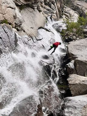
Rappel 1 (30 feet): Two bolts DCR. These bolts are set up for some kind of block like a figure 8 block etc. Do not put webbing on them. This rappel will put you on the very cliff edge of the next drop.
Rappel 2 (190 feet): Two bolts DRC. Again set up to be used without webbing and to allow an easy pull. It's best to send the first person with a rope so they can rig the next rappel because rappel 3 starts on a (very) small ledge.
Rappel 3 (200+ feet): Bolted anchors on a (very) small ledge. With a 200-foot rope, you'll be 20+ feet short of the flat ground. Getting off rappel on the slab and downclimbing the remaining distance safely is straightforward. In low water conditions, you can get off the rappel to the left of the waterfall (looking up canyon), allowing more people to meet at the rappel station. But there's still limited space, so sequence carefully.
Rappel 4 (190-230 feet): Bolted anchor options are available on DCR wall (230’ drop) or further forward on ground on cliff edge(<200’). This rappel starts on a large ledge and is an ideal spot to meet as a group, have a snack, and enjoy the spectacular views.
Rappel 5 (60+ feet): Another optional rappel. It can be downclimbed on the canyon left. But what's the fun of that? Bolted anchors make for easy rigging center under rock over hang or DCR on wall. Rappel is fun to slide in wet conditions.
Exit[edit]
Hike back to your vehicle and enjoy the rest of your day!
Red tape[edit]
Beta sites[edit]
 Climb-Utah.com : Great White Icicle
 RoadTripRyan.com : Great White Icicle
 HikeArizona.com : The Great White Icicle
 Super Amazing Map : The Great White Icicle
Trip reports and media[edit]
 Candition.com : Great White Icicle (Canyoneering)


