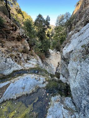
Hanging Valley
| Rating: | |||||||||||||||||||||||||||||||
|---|---|---|---|---|---|---|---|---|---|---|---|---|---|---|---|---|---|---|---|---|---|---|---|---|---|---|---|---|---|---|---|
| | Difficulty:3B IV (v3a2 IV) Raps:4-5, max ↨70ft
Red Tape:No permit required Shuttle:None | ||||||||||||||||||||||||||||||
| Location: | |||||||||||||||||||||||||||||||
| Condition Reports: | |||||||||||||||||||||||||||||||
| Best season: | Spring and Winter (avg for this region)
|
||||||||||||||||||||||||||||||
| Regions: | |||||||||||||||||||||||||||||||
Introduction[edit]
This is a beautiful canyon in Los Padres National Forest. The canyon was descended without ropes by going around the falls but that is not recommended at all. The locals did this canyon in the past without ropes and by doing some scrambling around the waterfalls, but the terrain must have changed as the work-arounds were exposed and dangerous. Watch out for loose ground and poison oak. The canyon drops into Arroyo Seco river so check the flow of the river before going. There are great options to camp by Arroyo Seco river if you do this as an overnighter.
Approach[edit]
From Escondido Campground hike up Indians Rd for about 4.3 miles. Turn left at 36.16898, -121.49467 and pass the (primitive) Hanging Valley campground. After about 800 feet, drop into the canyon around here 36.16898, -121.49467. There will be some bushwhacking.
Descent[edit]
Water flow was weak and almost to a trickle at places at the time it was descended (October). In wet seasons, it has the potential of becoming a moderate or even strong class C. There are 4-5 raps with the longest being estimated to be 60 or 70 feet. It's possible but very dangerous to work around each waterfall to bypass them, definitely not recommended. There were no particular challenges with the raps at the time. With higher flow of water, that may be different.
Note: currently there are no bolts or webbing anchors in the canyon. Try to use retrievable anchors or take enough webbing.
Exit[edit]
There are three options to exit, all of them are longish:
1. Easiest/fastest loop (no shuttle): once you drop into the Arroyo Seco canyon, go left (upriver) for a little over 5 miles. This includes lots of river walking so make sure you check the flow of the river before going! Keep going until you reach the Lost Valley Trail. Turn left and ascend the trail for over a mile until you get back to Escondido campground. The total exit is 7 miles as recorded by tracking but on Caltopo it comes to a little over 4.3 miles. It's probably because of lots of zigzagging and back and forth river crossing.
2. Shuttle route: once you drop into Arroyo Seco canyon, go right. This will take you all the way to the waterfall at the end of the canyon and the Arroyo Seco gorge. You will need a shuttle at Arroyo Seco campground. It's about a 2-3 hour shuttle set up and the campground has been closed for a while with no overnight parking allowed. Check status before going.
3. This is a potentially sketchy option, but the locals claim they have done it. Once you drop into Arroyo Seco, go right to next canyon were Jackhammer Spring drainage (ascending the drainage) and find your way back to the Indians road, then hike back to Escondido camp. There is no current beta on condition of the Jackhammer drainage and what challenge ascending it may pose. It's something to be explored further.
