Hell for Sure Canyon
| Rating: | ||||||||
|---|---|---|---|---|---|---|---|---|
| | Difficulty:3B IV (v3a2 IV) Raps:3, max ↨160ft
Red Tape: Shuttle:None | |||||||
| Location: | ||||||||
| Condition Reports: | 9 Nov 2024
"Parked outside the gate of the preserve and started hiking shortly after sunrise. The approach hike was beautiful with a good variety of different ter |
|||||||
| Best season: | ||||||||
| Regions: | ||||||||
Introduction[edit]
A spectacular canyon in the San Gorgonio Wilderness with a long approach, and likely an overnight stay to complete.
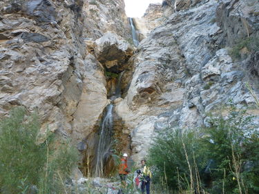
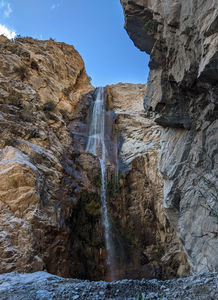
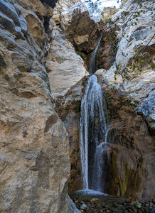
The canyon features two large beautiful waterfalls, as well as several smaller falls. There are many interesting downclimbs, especially if you're trying to avoid getting your gear wet. The short technical section has only four rappels; however the canyon is a worthy site to visit in the Southern California area.
Hell for Sure is a good introduction to overnight canyoneering, and is an excellent proving ground for your packing and gear management skills.
Approach[edit]
Much of the approach to Hell for Sure is off trail cross-country hiking, so good maps and navigation skills are mandatory. The approach route to reach Hell for Sure requires approximately eight and a half miles of hiking and covers portions of both the Catclaw Flat and White Water USGS quadrangles.
Park at the Whitewater Preserve (parking outside the main lot is still prohibited as of December 2019 due to a fire closure) and follow the "Canyon View Loop" trail approximately half a mile to where it joins the Pacific Crest Trail, then follow the PCT northbound approximately two miles to the Whitewater River crossing at Red Dome, a small iron-colored hill.
Approximately one quarter mile north of the river crossing, leave the PCT and head left (northwest) up a prominent wash, keeping the obvious hills on your right as you do so. Continue to contour around these hills for approximately a mile and a half, then keep right (north) and head gradually uphill into a wide valley/wash system marked as "Catclaw Flat" on topographic maps of the area. Follow a small wash toward the base of the hills to your left (west), then stay in the wash to contour around the base of these hills.
Keep left along the hills to pick up the remains of an old 4x4 road and follow it uphill to a saddle, where it forks. Take the right fork, follow the road north until it dies out in the chamise, and then work your way down into the wash to rejoin the Whitewater River. Again, keeping close to the base of the hills at your right will bypass the worst of the boulder hopping. Follow the river upstream for approximately one and a half miles. The Hell for Sure drainage enters the river drainage just north of a prominent stand of alders on the east side of the river.
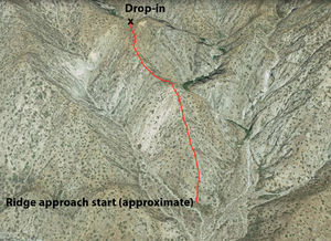
The final portion of the approach consists of a steep hike/scramble up the second of two rocky ridges encountered to your left (northwest) as you head up Hell for Sure Canyon. Be prepared for lots of loose, chossy rock and several exposed sections, particularly along the upper portion of the ridge.
Drop into the canyon via the obvious saddle at the top of the ridge.
Waterflow in the canyon can be inspected prior to the terminal ridge approach by entering the Hell for Sure drainage where it joins the Whitewater River, passing both the first and second ridges described above, and continuing up the wash to the base of R3. The entire technical portion of the canyon is visible from this vantage point.
Note: An alternate approach from Mission Creek may be possible (and perhaps more passable, with less bushwhacking over approximately the same hiking distance) but has not been scouted by the page authors. If this approach proves viable, it would join the documented route in the area of the fork in the old 4x4 road (signed on area topo maps as “Wathier Landing”).
Descent[edit]
A handful of nuisance 10'-15' drops are found above the final exit sequence, but most or all can be either bypassed or downclimbed.
- R0 (likely downclimbed by 1st descent party; not mentioned in trip report) 40' off log DCL
- R1 160' off rock chock anchor above waterfall (rock cairn alternate DCL avoids watercourse)
- R2 30' off tree anchor DCR
- Note: in the event that there are no anchor-building materials on the R2 ledge it may be necessary to combine R1 and R2 which uses about 220' of rope.
- R3 ~120' two-stage rappel off tree anchor canyon center (pinch point alternate DCR avoids watercourse)
Exit[edit]
From the base of R3, continue down canyon to the confluence of the Hell for Sure drainage with the Whitewater River and reverse the approach.
Red tape[edit]
Some of the approach to Hell for Sure Canyon falls within the Whitewater Preserve. Check before you go - rain in the forecast may close the preserve on very short notice due to washed-out roads or flash flood concerns. A permit (free at the Whitewater Ranger Station) is required for backcountry camping or planned exit from the Whitewater parking area (locked gate) after 5 pm. It's probably best not to mention canyoneering during your permit process.
The canyon itself falls within the San Gorgonio Wilderness. Current as of December 2019, day trips into the San Gorgonio Wilderness no longer require a permit, but visitors planning to overnight must obtain one.
The timing of your exit and location of your planned campsite (if you bivy) will determine which permit/s your trip to this canyon requires.
Beta sites[edit]
Trip reports and media[edit]
FIRST KNOWN DOCUMENTED DESCENT ON 10-20-12:
Background[edit]
Explored by Scott Swaney and party 10-20-12 (see trip report). Scott was told later that it had had a previous descent by San Bernardino SAR in the early 1970s, but no anchors were in place when his team descended the canyon. The upper canyon didn't appear to have much of interest to canyoneers.


