Hyde Draw
| Rating: | |||||||||||||||||||||||||||||||
|---|---|---|---|---|---|---|---|---|---|---|---|---|---|---|---|---|---|---|---|---|---|---|---|---|---|---|---|---|---|---|---|
| | Difficulty:3B I (v3a2 I) Raps:1-2, max ↨50ft
Red Tape: Shuttle: | ||||||||||||||||||||||||||||||
| Location: | |||||||||||||||||||||||||||||||
| Condition Reports: | |||||||||||||||||||||||||||||||
| Best season: | Spring through fall.
|
||||||||||||||||||||||||||||||
| Regions: | |||||||||||||||||||||||||||||||
Introduction[edit]
Exit 131 off Interstate 70. Go north 50 feet then east on the dirt feeder road for 3.3 miles then right to go underneath the interstate. Once on the south side of the interstate, make a left and go for a couple miles, take the second right that leads you to Hyde Draw Reservoir. At Hyde Draw Reservoir take the dirt road on it's south side for about 1 mile to the Parking/Camping Spot. There are many primitive camping sites available.
- Parking/Camping Spot: 38.85141, -110.55993
- Entry/Drop-In: 38.84681, -110.55051
- Confluence with Eardley: 38.84252, -110.55819 go right up Eardley
- Exit Up to Rim: 38.84893, -110.56473
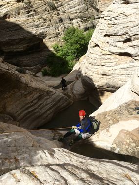
Getting to the first rappel may require a handline for most. The last man can be partner-captured from below. There are several swimmers. The keeper pothole was well filled in and very easy to walk off on an underwater ledge on the left as of May 2016.
Approach[edit]
Descent[edit]
Exit[edit]
Red tape[edit]
Beta sites[edit]
 RoadTripRyan.com : Hyde Draw
Trip reports and media[edit]
June 4, 2017 - Keeper can be easily bypassed by climbing around it on the left. Last rappel can be easily downclimbed with good friction slide on butt and shoes with good grip.
