Kreuzgraben
| Rating: | |||||||||||||||||||||||||||||||
|---|---|---|---|---|---|---|---|---|---|---|---|---|---|---|---|---|---|---|---|---|---|---|---|---|---|---|---|---|---|---|---|
|
| |||||||||||||||||||||||||||||||
| | Raps:max ↨148ft
Red Tape: Shuttle:None Rock type:Limestone | ||||||||||||||||||||||||||||||
| Location: | |||||||||||||||||||||||||||||||
| Condition Reports: | |||||||||||||||||||||||||||||||
| Best season: | Jun - Oct
|
||||||||||||||||||||||||||||||
| Regions: | |||||||||||||||||||||||||||||||

Introduction
Kreuzgraben is the largest right tributary of the very famous tourist gorge Garnitzenklamm and is located on the Austrian side of the Carnic Alps in Kärnten near Hermagor. The canyon is very steep and mostly enclosed in its whole length with only one short open section. There are many beautiful rappels, sometimes directly into the water. The environment is extremely interesting due to the enormous walls that soar over the canyon, rock is a nice smooth and we can see some huge stuck boulders. The only bad side of this canyon are some wedged trunks in the streambed. Kreuzgraben is probably the best canyon, which was explored in the last few years in the Kärnten area and offers to you a really nice descent. Avoid it after rain and at unstable weather, danger of flash flood.
Zone: Austria – Kärnten – Hermagor
Dimensions: Entrance: 1390 m Exit: 1150 m Height: 340 m Length: 1000 m
Period June - October
Times: Approach: 35 min Progression: 3-3.5h Return: 40 min + 20 min (to the Egger Alm)
Shuttle: Not necessary. (It is possible to use a second car for around 2 km of drive or 20 minutes of walk.)
Equipment: Sufficient (with 10mm bolts with rings). Take some cutting rope with you.
Rope: 2 x 45m
Highest waterfall: 40 m
Possible exit No
Maps: Carta Tabacco 18 and Kompass 60 Gailtaler Alpen - Karnische Alpen - Oberdrautal
Attraction: Regional
Difficulty: V4 a3 IV
Approach
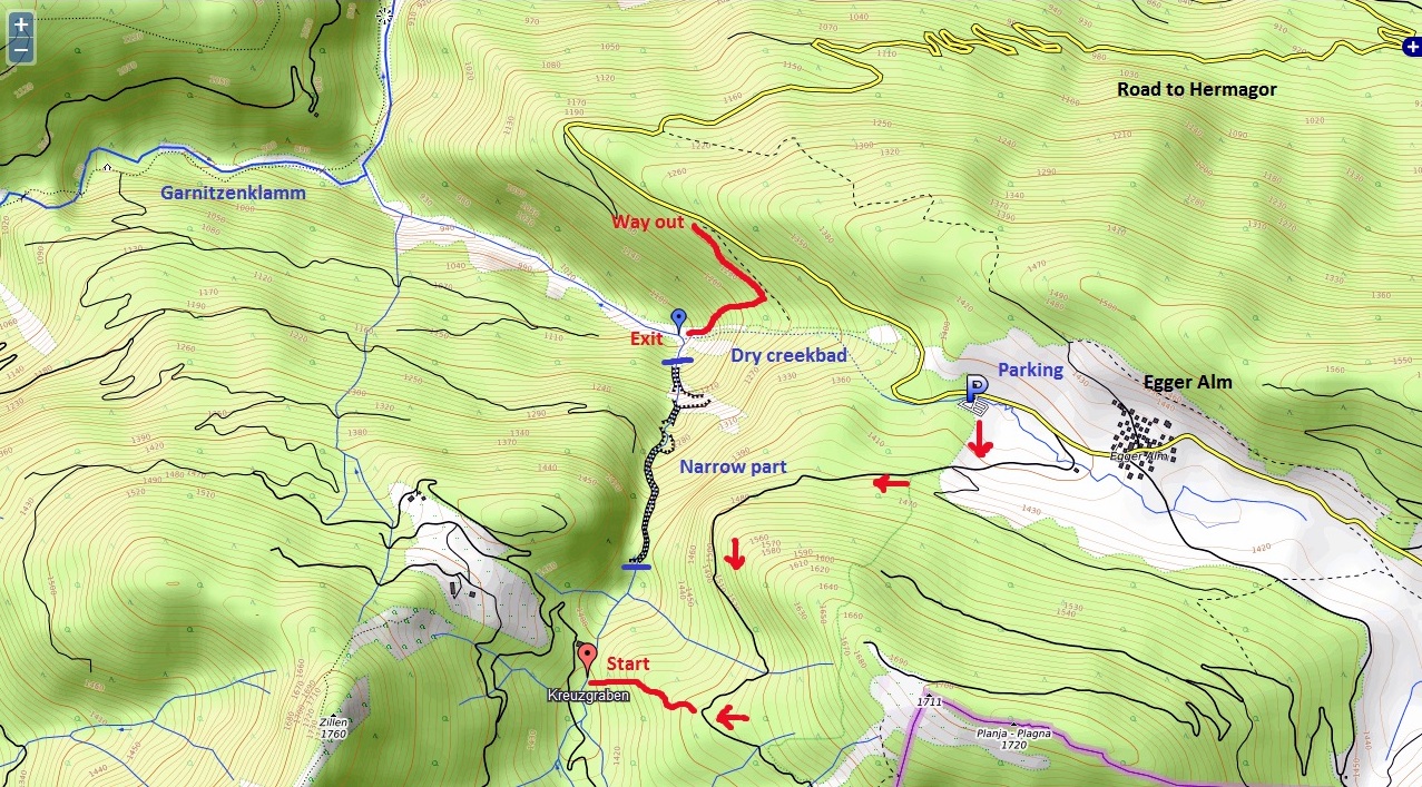
From the direction of Villach, drive to Hermagor, where you select the second exit in the roundabout for Kötschach Mauthen and after about 200 metres, turn left and follow the signs for Möderndorf/Garnitzenklamm. Continue on this road, cross the railway line, drive through Möderndorf and past the entry for the Garnitzenklamm gorge. Follow the road steeply uphill until you reach the big parking place at Egger Alm. If you have a second car, find a parking place near the logging road on the long traverse up to Egger Alm at about 1260hm.
From the Egger Alm parking lot, climb over the fence at the edge of the forest and climb up to the forest road crossing the meadow further uphill. Follow the slightly ascending forest road until it crosses a tiny stream. After 200m you will reach a clearing (N 46.578781 ° E 13.363665). Turn right and descend the ridge until you reach a raised hide for hunters. From here, follow faint tracks downwards until you reach the creek. Go downstream until you stand before an old wooden barrier.
Descent
D 10m or bypass (R)
J 1m
D 14m bypass (L)
W 50m
D+W 50m
C 5m: 1 bolt with maillon (R) C 10m: tree with rope (L) Inlet (L)
W 150m
Inlet (R)
C 15m: 2 cascades - tree with rope (L) - Start of the first narrow part.
C 11m: 1 bolt with ring (L)
T 1'5m
C 7m: 1 bolt with rope and ring (L)
D 20m wedged trunks
C 10m: 1 bolt with ring (L) C 15m: 1 bolt with ring (R) C 8m: 1 bolt with ring (R)
C 12m: 1 bolt with ring (R) – climb up
D 4m (L)
D 2+ 3m
C 14m: 1 bolt with ring (R)
C 20m: 1 bolt with ring – very high (R) – S cascade
D 5m
MC 3m: 1bolt with rope and ring (R) – huge boulder
C 40m or 30 +10m: 2 bolts with rings - hanging (R) – after 30 meters are 2 bolts with maillons (R) - 2X45m of rope – End of the first narrow part.
W 120m open flat area
C 7m: 1bolt with rope and ring (R) – Start of the second narrow part. C 34m: 2 bolts with rings (L) – into the water!
MC 3m: 1bolt with maillon (L)
C 24m: 1 bolt with ring (L)
D15m
C 17m: 1 bolt with ring – very high (L)
W+D 20 m
MC 2m: 1 bolt with maillon (R)
C 25m: 1 bolt with maillon (R)
C 7 + 3m or J7m: 1 bolt (8mm) with maillon (R)
D 15m: End of the second narrow part.
There is still about 200m of difference in height till you reach the hiking path in Garnitzenklamm. This part has not been descended yet. Lower Garnitzenklamm is a highly aquatic canyon with many high jumps.
Exit
After exiting the narrow part of the canyon, you are in an open area where a dry creek bed (dry inlet) enters from the right. Ascend this creekbed for a good 150hm and turn left into the steep forest as soon as you can see a raised hide on your left. Ascend through the trackless forest until you reach the logging road and follow this road to the left until you reach the street again. Follow this street for about 20min to Egger Alm.
Red tape
Beta sites
 Canyon.Carto.net : Kreuzgraben
 Descente-Canyon.com : Kreuzgraben
Trip reports and media


Background
First descent: Canyoning Cult (David Sefaj, Georg Buol, Grega Maffi, Matic Udir, Robert Žerovec, Tom Prettner) and Hannes Holzer on 23th of October 2016. First repetition: Austrian Canyoning Association on 30th of October 2016.