La Barranca
| Rating: | |||||||||||||||||||||||||||||||
|---|---|---|---|---|---|---|---|---|---|---|---|---|---|---|---|---|---|---|---|---|---|---|---|---|---|---|---|---|---|---|---|
| | Raps:12-16, max ↨98ft
Red Tape: Shuttle:Required 14mi or 40min | ||||||||||||||||||||||||||||||
| Start: | |||||||||||||||||||||||||||||||
| Parking: | |||||||||||||||||||||||||||||||
| Shuttle: | |||||||||||||||||||||||||||||||
| Condition Reports: | 19 Apr 2025
"Such an incredibly beautiful canyon with many memorable features. Car-to-car time reflects the full route. With shuttle time included this is a 10+ ho |
||||||||||||||||||||||||||||||
| Best season: | November-June, COLD Jan-Feb
|
||||||||||||||||||||||||||||||
| Regions: | |||||||||||||||||||||||||||||||
Introduction[edit]
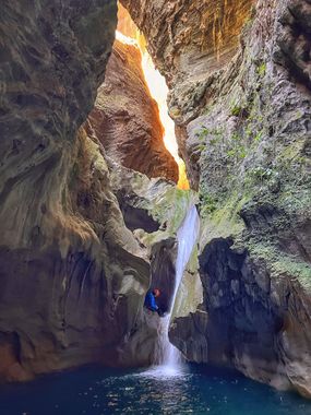
A beautiful and deep canyon with numerous dark, cavern-like sections and fun waterfall rappels, having many fun jumps and one really great slide. The narrows section takes many hours to go through.
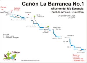
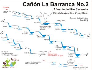
This canyon is frequently done in its entirety, with leaving a shuttle car at the Puente de Dios tourist attraction at the bottom. There is also trail access DCR about 1/4 of the way down the technical section (where a concrete footbridge crosses the gorge), so the canyon can be broken into two sections (these are 1 and 2 on the side profiles). However, the upper technical section only takes about 2.25 hours to do (plus approach/exit hiking), so it can be a short day without doing the whole thing.
Additionally, there is an alternate approach named La Escondida (The Hidden), that adds a 45m rappel. If you are only doing the upper section of this canyon you may want to try this approach to add more to the day.
Be sure to read the Queretaro region notes for more information on the area.
Approach[edit]
You can drive out to the upper parking area marked on the map, which is a mile down a narrow rough rock road right next to some local houses. Or, you can park near the bus "station" in Pinal de Amoles, and walk the additional mile (or even walk straight from your accommodations if staying in Pinal). From the main parking spot, drop down towards the canyon on the obvious trail along the rocky wall.
Note that this trail bypasses R1 on the Upper Section topo diagram. It's not clear how to drop in above that rappel using the current gps track.
To approach just the Lower Section, take the early-exit trail indicated on the map. This is also the exit if you are doing just the Upper Section. It takes about 45min to walk down, or 1.5hr to walk up this trail.
Descent[edit]
Upper Section (Barranca I)[edit]
The upper section is well bolted, having been upgraded in Nov 2024.
- The first major rappel of the upper section is a two-stage (from a tree), so rappel to the dark pool, then continue through the crack to the big open grotto (and intermediate anchor station here would be nice).
- The second major rappel is from two bolts DCL. This drops into a dark twisted cavern, trending DCR can keep you out of some pounding flow. The final exit from the cavern is a short jump.
- The third and final major rappel is from two bolts DCL. This can be done by rappelling to the open pool directly below, then swimming across (under a log), and sliding down the second-stage ramp.
Proceed 800m downstream to reach an overhead concrete bridge, which marks the early-exit trail. If exiting here, you do not need a vehicle shuttle.
Lower Section (Barranca II)[edit]
Exit[edit]
Upper[edit]
If just doing section 1, exit RDC at the concrete footbridge, and hike about 1.5hrs up a well-established livestock trail to the road. At a junction you will reach the approach trail; take it the rest of the way up. It is easiest to cross the rocky wall at this junction by climbing up the hillside for 100m or so.
Lower[edit]
The canyon eventually opens up and you reach cow paths and manure, and rock-hop for a while.
A path meets the canyon (at 21.18037, -99.62281) and can be used to bypass a sizeable chunk of creek walking.
Luckily you don't miss out on the exploring Puente de Dios, as after 1.4km a smaller trail leads back down into the canyon, arriving just upstream side of the cave. From here you can play in the pools and use the tourist trails to return to the parking lot.
Alternatively you can remain on the larger trail climbing and descending a few times all the way back to the parking lot.
You might as well explore the cave, as they'll be making you pay for it regardless of the path you walked.
At Puente de Dios we hired a local guy with a pickup truck to shuttle us back to our vehicle in Pinal de Amoles for 600 pesos (Nov 2024).
Red tape[edit]
They'll catch you as you exit through Puente de Dios. The fee was 181 pesos per person (Nov 2024). Parking here is 70 pesos per vehicle (Feb 2022).
Beta sites[edit]
 Wikiloc.com : Cañón la Barranca
 Wikiloc.com : La Escondida
 Cañonismo.com : La Barranca I
 Cañonismo.com : La Barranca II


