Leave it to Beaver
| Rating: | |||||||||||||||||||||||||||||||
|---|---|---|---|---|---|---|---|---|---|---|---|---|---|---|---|---|---|---|---|---|---|---|---|---|---|---|---|---|---|---|---|
| | Difficulty:3B III (v4a2 III) Raps:7 - 8, max ↨100ft
Red Tape:No permit required Shuttle:None | ||||||||||||||||||||||||||||||
| Location: | |||||||||||||||||||||||||||||||
| Condition Reports: | 9 Jul 2022
"This canyon is mediocre at best. The scenery on approach and technical section is fairly bland and the rappels are lack luster.. Approach up Long |
||||||||||||||||||||||||||||||
| Best season: | All;Winter
|
||||||||||||||||||||||||||||||
| Regions: | |||||||||||||||||||||||||||||||
Introduction[edit]
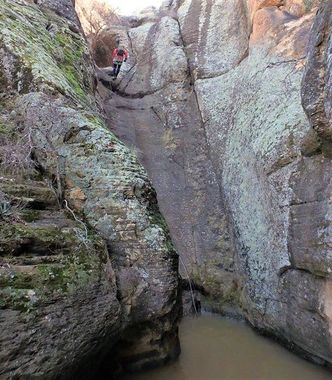
This 3B III canyon, Video and photo set here > https://youtu.be/hbrgD5MCnA0 https://www.facebook.com/media/set/?set=a.1541698855850549.1073742091.100000313473011&type=3 (possibly a 3B II if your in a hurry) is located in the Wet Beaver Creek Wilderness area just off of I-17 where you pick up Long Canyon Trail 63 and head up to the top. The approach and the exit is all trail so that's nice. First descent claimed by, Myself, Jason Danoff and Todd Holmes. The technical section is relatively short, around 1 mile in length but packs a nice little punch with 8 rappels, a short section of narrows, 2 to 3 swimmers and plenty of down climbs, followed by a beautiful hike on the Weir trail then the Bell trail back to your vehicle. This exit can be pack-rafted at 150 to 200 CFS as well. We did another first descent deeper in the Wet Beaver Wilderness a few years ago that had a nice technical section with 5 rappels but it was a super long trip with an overnight down along the creek. Leave it to Beaver might very well be the only technical canyon worth doing in that area.
Approach[edit]
Long Canyon Trail 63 to Long Canyon Tank. Drop into the drainage there.
Descent[edit]
8 rappels, Anchors are set. Check Wet Beaver Creek CFS Rimrock gauge https://waterdata.usgs.gov/az/nwis/uv/?site_no=09505200&PARAmeter_cd=00065,00060 before running the canyon for creek crossing hazard. It was at 114 cfs when we crossed the creek.
Exit[edit]
Weir Trail to Bell Trail and to your vehicle or packraft at 150 to 200 CFS https://waterdata.usgs.gov/az/nwis/uv/?site_no=09505200&PARAmeter_cd=00065,00060
Red tape[edit]
Beta sites[edit]
 WildPathsAZ.com : Leave It to Beaver Canyon
Trip reports and media[edit]
- A full grown dead cow elk was encountered in the canyon at the bottom of the 1st rappel in April 2021. It will likely take a year to decompose
Background[edit]
First descent by Jay Wisocki, Jason Danoff and Todd Holmes
