Leopard
| Rating: | |||||||||||||||||||||||||||||||
|---|---|---|---|---|---|---|---|---|---|---|---|---|---|---|---|---|---|---|---|---|---|---|---|---|---|---|---|---|---|---|---|
| | Difficulty:4B II R (v5a2 II) Raps:2, max ↨35ft
Red Tape:Permit required Shuttle: Rock type:Sandstone | ||||||||||||||||||||||||||||||
| Location: | |||||||||||||||||||||||||||||||
| Condition Reports: | 28 Apr 2018
"3 hours camp to camp from our base camp at the end of Humble Beginnings (Ocelot). A few moderate keepers along the way, low water levels, but we did |
||||||||||||||||||||||||||||||
| Best season: | Spring or Fall
|
||||||||||||||||||||||||||||||
| Regions: | |||||||||||||||||||||||||||||||
Introduction[edit]
- THE FOLLOWING BETA IS FOR LOWER LEOPARD ONLY
Approach[edit]
Descent[edit]
This route description only details Lower Leopard starting at: 36 56' 20" N 111 03' 20". This set of beta is also incomplete because we explored the canyon when it was completely full. We suspect that the most interesting features of this canyon were hidden by the water. We are certain that there are several very large keeper potholes in this lower section. How difficult are they? It is tough to guess, because we swam over the top of them. We can say that their geometry was significantly worse than any of the other eight canyons we have done in the area. We jumped into a few of them without touching the bottom.
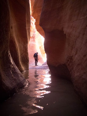
Lower Leopard is a beautiful slot, one of the best in the area. It has a couple of pothole rooms that boggle the mind- you must downclimb into them before you can see if the exit goes right, or if it goes left. Literally, from the entry side of those potholes it appears that there are no exits at all.
Why might those potholes be a problem? Well, if the canyon were half full, throwing a Potshot across those ‘blind’ potholes would not be possible. Are all of the ‘blind’ potholes keepers? We think there is a high likelihood that they are.
The water in Lower Leopard was extremely cold, a bit colder than the surrounding canyons. There was a lot of swimming required, so go prepared.
About hallway through the canyon you will need to do a 30 foot rappel from a Sandtrap. The pull is difficult, down into a hallway full of water.
The final rappel is 35 feet from a single well-placed bolt into a stunning riparian section. We scouted the route from the bottom and spotted the bolt, so we hoped to pull it. When we arrived at the bolt, we discovered that the drop had VERY difficult geometry. It looked impossible to rig naturally, even with a water anchor. The group that placed that bolt probably had no other choice. Jumping from that perch into the pool below (something that looks possible from below) is not an option because there is a shelf hallway down that gets in the way. In the end, we ended up leaving the bolt. If you discover a clever way to rig this anchor without leaving a groove, especially when the canyon is full, I would love to hear your story.
From the final drop it is a simple 10 minute walk to West through an insanely gorgeous section of narrows.
Time: This loop took us 2.5 hours moving fast. I think it would take much longer if the canyon were half-full.
Rappels: 30 feet from a SandTrap, 35 feet from a single bolt.
Mandatory Equipment: SandTrap, SandTrap pullcord sheathed with webbing, 70 feet of rope, standard rappelling gear. If the final bolt gets pulled, then a water anchor is mandatory. It is easy to scout the final drop from the bottom of the canyon to see if the bolt is still in place. 3 Potshots and a couple of extra ropes would likely come in handy if the water conditions are less than full.
Neoprene: 5/4mm full length suits, booties, gloves, vest, hood, beanie. 7mm suit if you get cold easily.
Please play fair and do not add bolts to this route. If you choose to pull the bolt at the final rappel, something I’m neither for nor against, please be considerate of others that might use this beta by sending me a note.
Exit[edit]
Red tape[edit]
Hiking in this area requires a permit from the Navajo Nation. I recommend mailing your permit request a few weeks in advance, along with a very polite letter explaining your trip itinerary. Permit information can be found here:http://navajonationparks.org/permits.htm
Beta sites[edit]
 Super Amazing Map : Leopard
https://amazingslots.blogspot.com/2017/05/west-canyon-beta-lake-powell.html
Trip reports and media[edit]
http://amazingslots.blogspot.com/2017/04/west-canyon-2017-leopard-canyon.html
