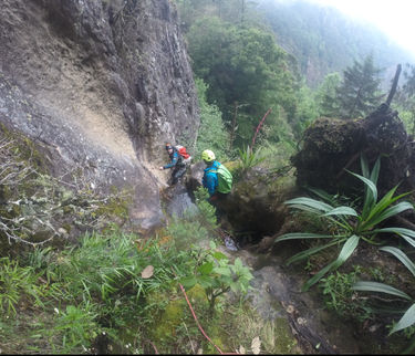
Lower Chiflon (entrada Chifloncito)
| Rating: | ||||
|---|---|---|---|---|
| | Raps:~20, max ↨164ft
Red Tape:No permit required Shuttle:Required 45 min Rock type:riolito? | |||
| Location: | ||||
| Condition Reports: | 1 Apr 2021
"if you can find a way to skip Chifloncito, do it. brushy and muddy. the big rap is cool but thats pretty much the only part. lower chiflon was beauti |
|||
| Best season: | ||||
| Regions: | ||||
Introduction[edit]
This is a brushy "technical bushwack" approach followed by a beautiful and deep aquatic canyon. This is ejido land so ask permission from anyone you encounter and explain to them what you are doing. Better yet, contact Enock of Club Xel, the guy who opened all the canyons in the area. He'll house and feed you and give you all the info you need. Really helps to speak some Spanish.
Approach[edit]
After leaving the labeled roads above the drop-in, you follow the dirt roads as close to the drop-in as is feasible. The approach on the kml map may include some nuisance rappels. The labelled "Better Entrance" is a trail coming in RDC that would likely be a better approach (less bushwacking) if someone can figure out where this trail starts
Descent[edit]
The point on the map is where a trail comes down to Chifloncito, but we haven't yet found the top of this trail. The part above it sucks, with alot of bushwacking and some brushy rappels. The part below has several rappels and a bunch of downclimbing. There are some cool chutes that go through tunnels of vegetation. The highlight is a 50 meter rap down a sloping, sculpted water fall. Aside from this and a couple other interesting sections, the route is mostly way to access lower Chiflon. Once in here, the flow is much higher and it starts to get good. There are 7 rappels in Chiflon, one of which (R5?) can be quite intense at higher flows and has a pasamano LDC to get you out of the flow. It has 3 points and is exposed so you have to know how to rig a retrievable handline to use this. The canyon ends when you reach the bridge. The last 5 rappels take you through a gorgeous and deep canyon with clear water and plants hanging from the walls.
Exit[edit]
If you haven't left a vehicle at the bridge or arranged a pick up, you can try hitchhiking like we did (successfully).
Red tape[edit]
It is best to get in touch with Enock of Club Xel (+52 55 4766 1825) to do these Agua Blanca canyons. He will set you up with sweet food and accommodation and maybe help with shuttles. If he's around, he might go with you. This is mostly ejidal land and it really is best to know a local. At least, explain what you're doing to anyone you come across and ask if it's ok if you continue. Should speak some Spanish.
