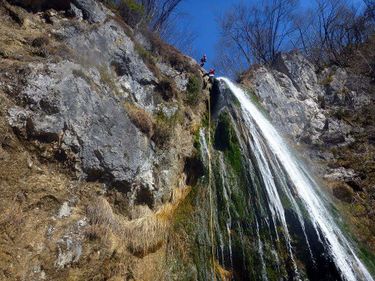
Malenscek (Brinta)
| Rating: | |||||||||||||||||||||||||||||||
|---|---|---|---|---|---|---|---|---|---|---|---|---|---|---|---|---|---|---|---|---|---|---|---|---|---|---|---|---|---|---|---|
| | Difficulty:4A II R (v5a1 III) Raps:max ↨279ft
Red Tape: Shuttle:Required 7 km | ||||||||||||||||||||||||||||||
| Location: | |||||||||||||||||||||||||||||||
| Condition Reports: | |||||||||||||||||||||||||||||||
| Best season: | Mar - Oct
|
||||||||||||||||||||||||||||||
| Regions: | |||||||||||||||||||||||||||||||
Introduction[edit]
Malenscek is one of the three mayor canyons that have a spring under the Krn mountain, has the highest waterfall, but it also has the least water. Highest waterfall Brinta officially measured 104 meters and is one of the highest waterfalls in Slovenia. Highest waterfall Brinta officially measured 104 metres and is one of the highest waterfalls in Slovenia.
Zone: Primorska – Posočje – Tolmin
Qualities: Entrance: 680 m Exit: 215 m Height: 410 m Length: 1600 m
Period March-October
Times: Approach: 0 min Progression: 4 h Return: 1 min
Shuttle: Yes, 7 km
Equipment: Unsufficient
Rope: 1 x 85 m / 1x 60 m, 1 x 30 m (This is for the minimum)
Possible exit Yes (waylessness) After the first cascate (path on right) and after the Brinta waterfall (path on right).
Maps: Julijske Alpe – zahodni del (1:50.000), Krn 1:25.000
Attraction: local
Difficulty: V5 (hard) a1 III
Approach[edit]
From Kobarid to the village of Selišče (10 km). Park one car near the Volarja river. Then drive with the second car to the village Kamno, cross Vrsno village and continue on the road to Krn village and when you get to the first bridge, a small park on the left side (for one car only). Here is the entry. .
From the bridge continue on the left side to the creek.
Descent[edit]
The descent over the Brinta waterfall is out of the water. The stream has low water during the summer.
500 m walking
C 28m: 2 spits(old and rusty) with rope (R) Very exposed, it is necessary to make a
MC from the little tree.
C 6m: bypass on the right
500m walking
D 3m
C 7m/ Sp: 1 spit 10mm (new) (R)
MC 2m: 2 spits 10mm (good) (L)
C 110m or 104m:- 25m, 2 spit 10mm (ok) with rope (L)
- 85m, 2 spit 10mm (ok) with a lot of old ropes (L) Anchorage has place for two people only and it's hanging.
Attention: It is necessary to swing 2 m to catch anchorage.
300m walking
C 8m: downclimb
C7m: 1 piton with rope (R)
C 5m: tree with rope (R)
300m walking
Volarja stream comes from the left side.
Then follow the stream to the little dam and then path starting on the right side of the bank (1 min to the car).
Exit[edit]
Red tape[edit]
Beta sites[edit]
Trip reports and media[edit]
Background[edit]
Canyoning Cult Slovenia
