Mulino
| Rating: | |||||||||||||||||||||||||||||||
|---|---|---|---|---|---|---|---|---|---|---|---|---|---|---|---|---|---|---|---|---|---|---|---|---|---|---|---|---|---|---|---|
|
| |||||||||||||||||||||||||||||||
| | Difficulty:3B I (v3a2 II) Raps:max ↨75ft
Red Tape: Shuttle:None | ||||||||||||||||||||||||||||||
| Location: | |||||||||||||||||||||||||||||||
| Condition Reports: | |||||||||||||||||||||||||||||||
| Best season: | Jun - Oct
|
||||||||||||||||||||||||||||||
| Regions: | |||||||||||||||||||||||||||||||

Introduction
Rio Muhlbach is a small and short canyon located in center of Sappada in Veneto region (Italy). To the higest waterfall a tourist route leads from Sappada, because it is a local attraction. The canyon are equipped by local guides for guiding. The canyon is open and never enclosed. This Canyon is recommended only in cases that you have little time or as the second canyon and of course, if you are already in the region.
Zone: Italy – Veneto - Sappada
Dimensions: Entrance: 1400 m Exit: 1250 m Height: 150 m Length: 700 m
Period June-October
Times: Approach: 35 min Progression: 1 h Return: 2 min
Shuttle: No
Equipment: Sufficient
Rope: 2 x 25m
Biggest waterfall: 23 m
Possible exit Yes (almost everywhere)
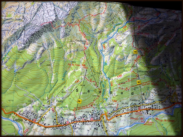
Maps: Carta Tabacco 01 (Sappada-S.Stefano-Forni Avoltri)
Attraction: Local
Difficulty: V3 a2 II
Approach
In the center of Sappada park the car in the parking lot on the left side of the bridge across the Rio Muhlbach, on the main road Sappada-Forni Avloltri.
Longer approach: From the parking lot, cross the bridge and immediately turn left (sign for marked path CAI 135) , follow the road to the school, where you turn left. Followed by bad road that winds steeply up the hill to the small church, follow the road next to the old house where is a sign for Riffugio M.Ferro-marked path CAI 141 (on the left side are ski fences), turn left and descend to the stream bed. On the right side of the creek descent to the concrete barrier, bypass it on the right and you are on the start of the canyon.
Shorter approach: From the parking lot turn left and find the marked path Cai 3 Sentiero Nat. Ferro. Take this path and after about 100 high meters when the path close to the creek, turn right into the riverbed. This approach is unverified and probably this is the entry used by local guides.
Descent
D+W 40 m
C 12m: tree (L) uneqipped
W 100m possible exit
T 3m
C 5m: 1 bolt(R)
MC 4m: fixed chain (R )
C 8m: 1 bolt connected with chain (R)
MC 4m: fixed chain (R)
C 23m: 2 bolts connected with chain (R)
Meeting with tourist path
C 8m: 1 bolt (L)
C4m or S4m: 1 bolt (R)
Exit
After the last waterfall climb on the bridge and follow the path to the parking place (2 minutes.
Red tape
Beta sites
 Canyon.Carto.net : Rio del Mulino
Trip reports and media
2.jpg)
3.jpg)
4.jpg)
5.jpg)
6.jpg)
7.jpg)
8.jpg)
9.jpg)
1.jpg)
Background
If you use a shorter approach the time for approach and dimensions of the canyon splits almost for half.