North Fork Kaweah River (Upper)
| Rating: | |||||||||||||||||||||||||||||||
|---|---|---|---|---|---|---|---|---|---|---|---|---|---|---|---|---|---|---|---|---|---|---|---|---|---|---|---|---|---|---|---|
| | Raps:10, max ↨85ft
Red Tape:No permit required Shuttle:Required 40 min | ||||||||||||||||||||||||||||||
| Location: | |||||||||||||||||||||||||||||||
| Condition Reports: | |||||||||||||||||||||||||||||||
| Best season: | Jul-Oct (avg for this region)
|
||||||||||||||||||||||||||||||
| Regions: | |||||||||||||||||||||||||||||||
Introduction[edit]
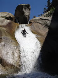
This is a great canyon that has 10 rappels and 10 jump/slides. The technical section of the canyon is very good, but relatively short compared to the total length of the hike. Small experienced groups might descend it in one long day, but most groups will opt for the two day option.
Approach[edit]
An alternative to the approach described in the beta is to start with Stony_Creek
Descent[edit]
Is it a jump? This canyon has more jumps than most into dark waters. Efficient meat anchors sending someone down to check the jump area will be the theme of the day. Goggles may not be a bad idea. Well placed bolts and pins are available at most anchors with the occasional natural anchor. Carrying lots of webbing between the group and many rapides/rappel rings is a good idea.
Dorst and Stony Creek are the two entry options you have for accessing Upper Kaweah. Stony has better parking and a bathroom. Having done both I find them equally fun with no real winner. Dorst requires shorter ropes which minimizes your weight in Upper Kaweah. *Safety note, the last drop in Dorst is a jump with dire consequences if you slip while trying to access the edge. Please use extreme caution here. After the jump you meet the confluence where Dorst and Stony meet to begin the Upper Kaweah River.
Rappels 5 and 6 pose the most technical part of the day. Rappel 5 drops 12' into a small bowl of swirling water. The first person down must then maneuver near the water's edge and crawl up to the bolts. The edge can be mossy and slippery. Being swept over the edge attempting to gain access to the bolts is a real hazard and the person above you manning the contingency anchor better be ready to lower you if you fall over the edge while still on rope.
The bolts here at Rappel 6 can be missing or damaged. Be prepared with a back up plan should they be missing. You can safely view them from atop Rappel 5.
After Rappel 8 you can see a granite slab at the river's edge. This is NOT the bivy. Continue past the obvious granite slab approximately 65 feet. On the right hand side of the river will be a smaller granite slab and a fire ring behind it with a canopy of oak trees. This is the bivy previous parties have used to break the canyon into two days. There are infinite places to bivy based on time, party size, and how much you like ants.
Enjoy a nice fire and the sounds of the river as you drift into a well deserved slumber. Do not be surprised to be visited by grey kit foxes during the night. Use SEKI (Sequoia and Kings Canyon National Park) approved bear storage techniques and abide by seasonal fire restrictions.
This is a true 'wilderness canyon' with large sections of boulder hopping and scrambling. This canyon is not recommended for the weekender canyoneer who enjoys a Sunday jaunt down 7 tea cups. It is physically demanding and technical. Expect to finish in two full days. Reaching Fish Camp in a single day would require an alpine start and the extra daylight given by summer. Those wanting to complete it in a single day best be prepared for a shiver bivy.
Canyon comparisons to help you judge whether to attept this canyon.Upper Kaweah is on par physically with Fish Fork and technically more difficult. Upper Kaweah is harder than Heaps in easy full pot hole mode.
Exit[edit]
You can exit as described in the beta or keep going and do North_Fork_Kaweah_River_(Lower)
Rappel 11? Those not wanting to do the last walk around the large waterfall can opt to rappel using a double pinch located 15 feet canyon left of the water course. The large pool below has an obvious fish camp on canyon left. The trail up to Cherry Flat starts about 40 feet on the right side. The trail is somewhat overgrown and occasionally pruned by unknown fisherman. The trail has some poison oak which can be avoided by going slow and watching carefully. Approximately 100 feet up the trail, right after you step over the Redwood Creek is a large granite slab. This is a great place to remove wet suits, repack, and dawn your dry hiking clothes.
The Cherry Flat exit is a decent trail leading up the hillside to a dirt road. The road is overgrown with manzanita, poison oak, and dead trees. It is advisable to have a high clearance 4x4 or a spirited driver in a Subaru Forester. If you choose to do this canyon early in the season, do not be surprised to find downed trees across the road. There is a nice turn out to park your vehicle at 36.62962°N 118.89955°W, elevation 4,242 ft. There is no cell service here so plan ahead.
Off-roading clubs generally possess the skills and vehicles required to safely clear a road with chainsaws and winches. Some clubs like LA County Trailcrew 4x4 club provide occasional training and are familiar with canyoneering.
Some have recommended a shorter shuttle route via Redwood Saddle through Whitaker's Forest but which Google Maps does not readily offer.
Red tape[edit]
Local land owners do not appreciate the random vehicle parked on the public road next to their house. Be prepared for angry individuals threatening to have your car towed. Plan ahead where you choose to leave exit vehicles and do your best to respect the privacy of locals.
Parties driving up Friday evening at different times may choose to meet at Eshom Point OHV area. It has two pit toilets and a large dirt lot. Here you have cell service and can check in with your group and loved ones.
Eshom point down to Cherry Flats will routinely have cattle grazing. Please be alert and keep your speed on the dirt road reasonable. You pass by a few private properties when going down to Cherry Flat so please keep your noise level down if it's late in the evening.
Beta sites[edit]
- Beta was originally posted on sierracanyons.org (now defunct), Open PDF
Trip reports and media[edit]
Background[edit]
First descent was lead by Jef Levin, the original date and circumstances of the event are unknown


