Pfeiffer-Redwood Creek
| Rating: | |||||||||||||||||||||||||||||||
|---|---|---|---|---|---|---|---|---|---|---|---|---|---|---|---|---|---|---|---|---|---|---|---|---|---|---|---|---|---|---|---|
| | Difficulty:3B IV (v3a2 IV) Raps:5, max ↨100ft
Red Tape:No permit required Shuttle:None | ||||||||||||||||||||||||||||||
| Start: | |||||||||||||||||||||||||||||||
| Parking: | |||||||||||||||||||||||||||||||
| Condition Reports: | 25 Mar 2023
"With the NOAA forecast at 50 degrees and sunny the temperature was close to ideal. This was run shortly after significant rains with the Big Sur river |
||||||||||||||||||||||||||||||
| Best season: | Feb-May
|
||||||||||||||||||||||||||||||
| Regions: | |||||||||||||||||||||||||||||||
Introduction[edit]
Featuring typical Big Sur views and a wide variety of bushwhacking experiences, this canyon offers middling rewards for a considerable expenditure of effort. Although there are some okay drops, most of the creek is dry in all but the wettest conditions, and the bushwhacking is unrelenting and poison oakridden. There is almost certainly something better you could be doing with your time than descending this canyon.
Approach[edit]
Hike up Mt. Manuel Trail until the ridgeline. Then, follow the marked ridgeline down into the drainage. Future trips might consider taking another ridge to get down into the canyon, since the bushwhacking gets much harder once in the ditch. The ridge to the farthest left of the drainage would be more direct, but is shadier and so would have worse bushwhacking through higher shrubs and poison oak.
Descent[edit]
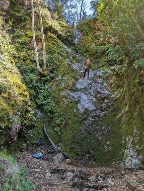
Trees in the drainage make for plentiful anchoring options. If possible, please use ghosting techniques to keep this canyon pristine. The final rappel drops you to the base of Pfeiffer falls, so expect onlookers at the adjacent viewing platform.
Exit[edit]
Hike back on one of the two state park trails to your car.
