Ritchie Canyon (Mildred Falls)
| Rating: | ||||||||||||
|---|---|---|---|---|---|---|---|---|---|---|---|---|
|
| ||||||||||||
| | Difficulty:3A II (v3a1 II) Raps:2, max ↨250ft
Red Tape:No permit required Shuttle:Required 3 min | |||||||||||
| Location: | ||||||||||||
| Condition Reports: | 22 Jun 2024
"The bolts are well placed in this canyon. The canyon was still trickling so some of the rappeling was slick with algae. Some of the access beta was ol |
|||||||||||
| Best season: | ||||||||||||
| Regions: | ||||||||||||
_Banner.jpg)
-20210512223332_pic.jpg)
-20230117042804_pic.jpg)
-20210512222926_pic.jpg)
-20210512222331_pic.jpg)
-20230306030356_pic.jpg)
Introduction
Ritchie Canyon contains the large Mildred Falls. Can be dry (there is a dam upstream) but will flow throughout the spring and in higher water years.
There is one road leading to the entrance/exit of this canyon (Eagle Peak rd, accessed via Julian). The road navigation programs might try to take you on from Poway is currently (2024) closed. The road connecting to the three sister's trailhead is blocked by a gate and closed. To do this as a combo with Boulder Creek as previously suggested would require backtracking and add significantly more drive time to the trip than it might be worth.
UPDATE: Climbing is no longer allowed at this location. The San Diego River Park Foundation purchased the 58 acres including the canyon and Mildred Falls access in October 2025. This is a very sensitive ecological area due to the presence of a golden eagle/peregrine falcon nest. Due to this and to the previous death we have determined that this area is not appropriate for climbing. We do work with ACSD on a regular basis and encourage climbing in the appropriate settings. We appreciate anything you can do to educate the climbing community and correct this information. Thank you so much for your time and consideration. -SDRPF
Approach
Note: San Diego River Foundation purchased 58 acres October 2025 including Mildred Falls access.
As you drive down the dirt road you will see Ritchie canyon meandering down on your right. Park at the Matthew Pack Memorial (white cross), then it is a short, easy walk into the canyon.
There are several animal paths and straightforward ways to navigate to and access the top of the canyon. From your car, head to the right and follow the ridgeline. If you drop down directly over the ridgeline, you will arrive near the top of Mildred Falls. If you continue to the right, you will drop down about a 5-10 minute walk before the falls and need to negotiate a little bit more of the creek. Both entrances are relatively the same length, difficulty, and time commitment.
Descent
Upstream of Mildred Falls
This section is bypassed by the direct approach
The first obstacle is a short 20ft drop into a narrow pool that can easily be walked around LDC.
Mildred Falls
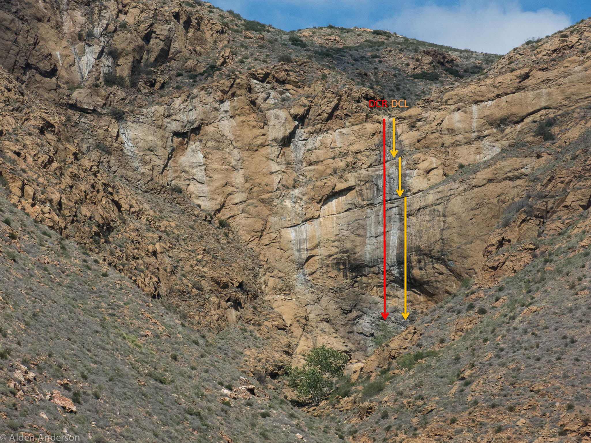
The view from the top of Mildred Falls is pretty amazing and you can't see any of the ledges, just the ground about 300 ft below you. This wall has very large blocks and ledges and you don't have a clear view of the bottom of the falls until the final pitch. Walkie-talkies are highly recommended on this wall. In water, communicating with whistles would be extremely difficult. There are two ways of descending this drop.
LDC descent
This descent is a 2 or 3 stage rappel mostly out of the watercourse under normal conditions. The LDC side has less abrasion risk, but station management should be actively used to switch wear spots if needed. If done in two stages, retrieve your top rope (R1) and pull the second stage (R2) as the pull from the first LDC anchor would be difficult. If you are doing either the 2 or 3 stage rappel, you should stay on rope and treat these as rebelay setups. The wall could be slick and while the ledges are large and comfortable, there is real risk of slipping and having a serious accident.
R1: 150ft, anchored to 2 bolts LDC. (This rappel may be split up into two rappels of roughly 70' using a set of bolts on the first large and obvious ledge in the canyon.) A 200ft rope is good for this first rappel. You won't be able to see the ledge for rappel 2 until you are over the edge.
R2: 250ft, anchored off 2 bolts LDC. The ledge here is large and you can sit several people at a well-managed anchor. Be careful not to kick rocks over the edge as you go over. There are 2 more ledges on the way down and finally a nice free-hang near the bottom (100+feet) so it might be a good idea to hang your pack.
RDC descent
This descent is a single long rappel directly in the water course requiring at least 300ft of rope; it is the more difficult and dangerous of the two options.
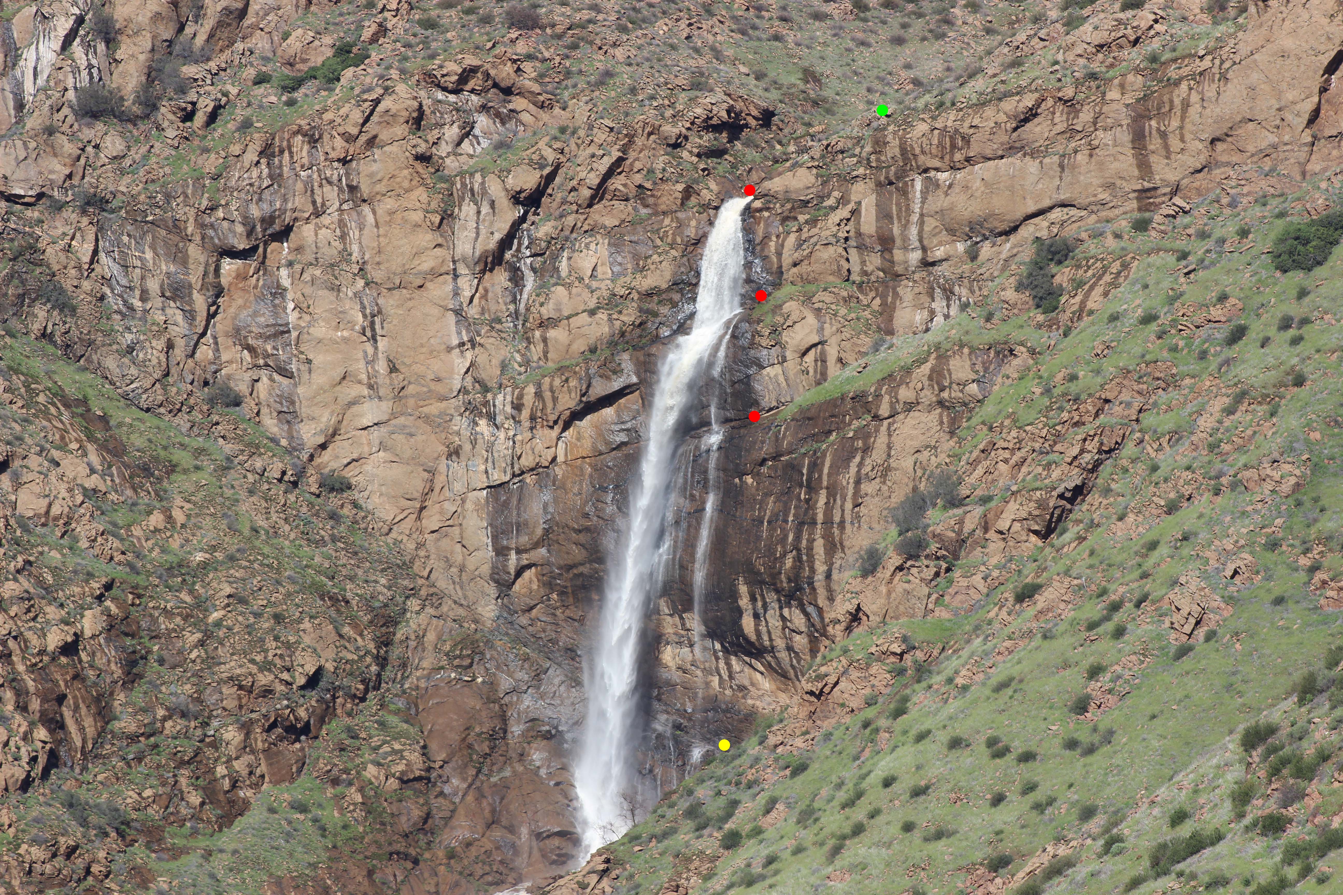
R1: 300ft+ directly in the watercourse, anchored to bolts RDC. Total height is around 390'
_sketch.jpg)
_pics.jpg)
This photo was taken when there was significant flow. It was not descended with this amount of water and is NOT recommended. It was to see location of anchors under higher flow. The lime green dot shows a good alternate first anchor. This puts you further away from the flow, since the top anchor was almost covered in water under these conditions. The red dots show the EXACT location of the bolted stations, so it is very much possible to avoid the water, up until the bottom when it overhangs. The yellow dot shows a ledge that is possible to get off on, traverse DCL and start making your way up the exit trail. A 300' rope will reach from the top, with an extended anchor (~15') to this ledge, with roughly 10' extra. Be very careful if getting off on this ledge when wet, and be sure not to go past it. A full single line descent would require at least 350' of rope if you wish to go past this ledge and all the way to the bottom. A 200' rope should suffice from the larger ledge (3rd red dot) all the way to the bottom but has NOT been attempted.
Exit
There are two possible exits from the canyon. Both exits converge at the same saddle between two cliffs. The exit is loose at the top and exposed (no shade) so bring extra water as it is an overgrown bushwhack with very little good scrambling but plenty of loose hillside.
First LDC exit
From the bottom of the falls, contour immediately LDC to the cliff face and traverse right when you see the car wreck and follow the scattered pieces up to the ridge back to the cross
Second LDC exit
After the last rappel follow the creek down to the second drainage LDC. There is a steeper drainage that enters DCL, keep going past this to the second, larger and easier drainage. You should be able to see where you parked your car at various places as you work your way down creek. There is a fair amount of poison oak so be wary of this.
When you get to the drainage follow the use trails up the ridge next to it, back up to your car. There is at least one drop in this drainage near the top that will prevent staying in it the entire time. There is also less poison oak if you stick to the ridge RDC of this drain
Creekbed exit
You can exit by following the creek bed and turning LDC at a shallow gully where the old Cedar Creek trailhead/crossroads is located. You would need a shuttle to do this exit, but in terms of time, it could roughly be equivalent (time-wise) to the LDC exits.
Red tape
It seems the stream up to the drop is actually on private land. When we got back to our cars (March, 2014) there was a guy on a quad wondering who was parked there, concerned it might be lost hikers. Turns out he owns the land here. It's a ranch upstream a little with a few ponds that can also control the flow of the creek and hence the falls. He explained there was a guy who died on the falls and SAR asked him to "turn off the water". It was moving pretty fast so he could only stop it for 10 minutes. Something to keep in mind if the creek is really flowing.
Beta sites
- Alpine Training Services incorrectly spells the canyon "Rechie Canyon"
Trip reports and media
Background
Fatal accident
Matthew Pack lost his life rappeling Mildred Falls. He may have thought both bolt stations were equivalent and the bolts on DCR would make for an easier pull. In that case, he would be unaware that route would require a 300+' rope and would put him directly under a heavy water flow. The scarcity of good beta on this canyon at the time (perhaps encouraged by canyoneers preferring to keep the beta a secret) may have contributed to the accident, but the availability of beta for this canyon on the ATS website at the time may suggest otherwise.