Standelbach
| Rating: | |||||||||||||||||||||||||||||||
|---|---|---|---|---|---|---|---|---|---|---|---|---|---|---|---|---|---|---|---|---|---|---|---|---|---|---|---|---|---|---|---|
| | Raps:30-35, max ↨164ft
Red Tape: Shuttle: Rock type:Granite | ||||||||||||||||||||||||||||||
| Start: | |||||||||||||||||||||||||||||||
| Parking: | |||||||||||||||||||||||||||||||
| Condition Reports: | |||||||||||||||||||||||||||||||
| Best season: | May-July
|
||||||||||||||||||||||||||||||
| Regions: | |||||||||||||||||||||||||||||||
Introduction[edit]
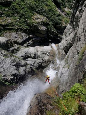
Long alpine canyon, it has two sections with nice waterfalls, almost at the top, and the very bottom.
Approach[edit]
Walk up to Riesflüestäfelo, the path is already not very marked. Then it is the best to work with satellite image as you can see a path starting north of the latter, at around 1650m and leading to the start of the canyon. In between you'll have to walk through a lot of high grass. Entering the canyon has been done by a 35m abseil from a tree.
Descent[edit]
It starts with large open 20-30m waterfalls before entering the first series of more vertical and condensed Rappels. Then the middle section is a lot of downclimbs, on the way, several smaller rivers join on both sides of the slopes. To finish, the last 100m of altitude are again interesting, including a 40m fall.
Exit[edit]
The canyon finishes right where the car is parked.
