Tech (Upper) Canyoneering Canyoning Caving descenso de barrancos Barranquismo
Also known as: Canyon du Tech; Gave d'Arrens; Garganta du Tech; Garganta du Tech Sup.
|
| Rating: |
Log in to rateLog in to rateLog in to rateLog in to rateLog in to rate 3.5 (2 ratings) |
|
|
| |
Raps:max ↨66ft | Overall: | 1.5h | |
|---|
| 5min | | | | 1h | ⟷984ft | ↑82ft | | 10-15min | | |
No Shuttle:None Rock type:Limestone |
|---|
| Location: |
|
|---|
| |
|---|
| Condition Reports: |
(log in to submit report)
|
|---|
Weather: |
|
|---|
| Best season: |
|
| Regions: |
|
http://descente-canyon.com/canyoning/canyon-description/21002,http://barranquismo.net/paginas/barrancos/garganta_du_tech_sup.htm,https://www.docuwiki.infobarrancos.es/doku.php?id=barrancosfra:hautespyrenees:tech
http://descente-canyon.com/canyoning/canyon-description/21002
42.9367, -0.2356https://ropewiki.com/luca/rwr?gpx%3Doff&filename%3DTech_%28Upper%29&kmlnfx&kmlx%3Dhttp://descente-canyon.com/canyoning/canyon-description/21002&ext%3D.kmlfrtopo
GPS data automatically extracted from
descente-canyon.com, please visit their site for more detailed information.
Introduction
Acceso desde: ArgelEs Gazost
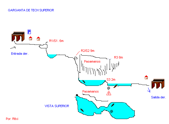
Altura de rápel mas largo: 9 metros
Información del caudal: caudal permanente y normalmente alto
Material necesario: una de 20
Neopreno: obligatorio, agua muy fría
Material de instalación: Aconsejable llevar material de instalación de repuesto
Observaciones: Rebufo al final de la gorga
Horario de aproximación: Inmediato
Horario de descenso: 1 hora
Horario de retorno: 10-15 min
Zona o macizo: hauts pyrenees
Cuenca: Gave de Arrens
Altura en inicio: 985
Altura en final: 960
Longitud: 300
Desnivel: 25
Carácter: engorgado y abierto
Tipo de roca: Calcareo
Combinable con el descenso de:con el tramo inferior y con varios de la zona de Gavarnie
Approach
Desde Argeles Gazost, tomaremos la D-918 dirección Arrens. una vez en Arrens tomaremos la D-105 dirección "Barrage du Tech" seguiremos y a nuestra izquierda nos queda ya la Gave de Arrens, llegaremos a un puente de piedra. En este puente de piedra hay un cartel indicador (Mine), hay un par de casas y al otro lado del río hay un gran explanada. 10 metros pasado el puente podemos dejar el coche e iniciar el descenso.
Descent
Barranco muy caudaloso, con un sitio estrecho y con rebufo en la recepción. Hay un gran pasamanos desde el segundo rápel hasta el último, (con esto nos evitamos toda la gracia del barranco.)
Exit
Acabado la zona engorgada nos encontraremos con unas ruinas, saldremos por la derecha hasta coger la senda de la "Mine" y volver al coche. También podemos continuar y hacer el tramo inferior, que no tiene ninguna dificultad técnica salvo un destrepe y un pequeño salto, en este caso seguiremos por el río hasta casi llegar al pueblo y retomar por la senda de la Mine a nuestra derecha.
Red tape
Beta sites
Trip reports and media
Background
11-Jul-06 Ritxi
_Banner.jpg)
 Descente-Canyon.com : Tech (supérieur)
 Barranquismo.net : Tech