Volarja (Pod Bregom)
| Rating: | |||||||||||||||||||||||||||||||
|---|---|---|---|---|---|---|---|---|---|---|---|---|---|---|---|---|---|---|---|---|---|---|---|---|---|---|---|---|---|---|---|
|
| |||||||||||||||||||||||||||||||
| | Raps:max ↨312ft
Red Tape: Shuttle:Required 9.5km Rock type:Limestone | ||||||||||||||||||||||||||||||
| Location: | |||||||||||||||||||||||||||||||
| Condition Reports: | |||||||||||||||||||||||||||||||
| Best season: | Summer
|
||||||||||||||||||||||||||||||
| Regions: | |||||||||||||||||||||||||||||||
_Banner.jpg)
Introduction
The Volarja gorge is one of the biggest and the most important canyons in Slovenia with very famous and one of the highest waterfalls in Slovenia – Gregorcicev slap (88 m). Volarja gorge consists of two streams - Podmlaka and Pod bregom, both are interesting for the canyoning.
Zone: Primorska – Posočje – Tolmin
Qualities: Entrance: 665 m Exit: 215 m Height: 450 m Length: 2500 m
Period April-October
Times: Approach: 10 min Progression: 4-5 h Return: 10 min
Shuttle: Yes
Equipment: Sufficient
Rope: 2 x 95 m / 2x 60 m, 1 x 20 m
Possible exit Yes (waylessness)
Maps: Julijske Alpe – zahodni del (1:50.000), Krn 1:25.000
Attraction: International
Difficulty: V5 a3 IV
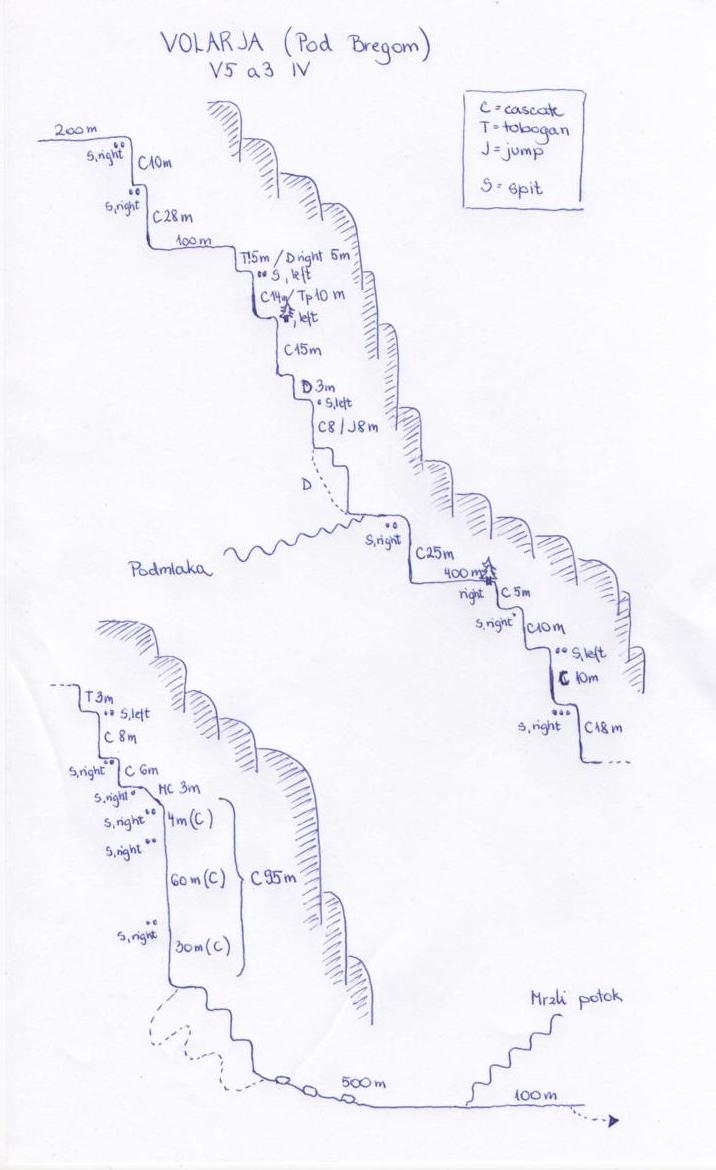
Approach
From Kobarid to the village of Selišče (10 km). Park one car near the Volarja river. Then drive with the second car to the village Kamno, cross Vrsno village and continue on the road to Krn village. Park near the Pod Bregom stream.
From the Pod bregom bridge continue on the left bank of the stream. About 10 min to the first waterfall.
Descent
C 10m: 2 spits with chain (R)
C 28m: 2 spits with nylon track (R)
100m walking
Tp! 5m/D (R)
C 14m/Tp 10m: 2 spits (L)
C 15m: tree with nylon track (L)
D 3mC 15m: 2 spits (D)
C 8m/Jp 8m: 1 spit (L)
Podmlaka stream from the right side
C 25 m: 2 spits (R)
400 m walking
C 5m: tree with rope (R)
C 10m: 1 spit (R)
C 10m: 2 spits
(L)
C 18m: 3 spits (R)
T 3m
C 8m: 2 spits (L)
C 6m: 1 spit
(R)
MC 3m: 1 spit (R)
C 95 m: 3 spits (R) !rope friction! OR
C 4m + C! 60 m: 2 spits with chain (R) + C! 30m: 2 spits with chain (R) (hard to find)
see the note!!!
bypass 3 waterfalls (unequipped) on the right side (small path)
D + walking 500 m in the riverbed
Mrzli potok stream from the left side
Then follow the stream and then path starting on the right side of the bank (10 min to the car).
Exit
Red tape
Beta sites
 Descente-Canyon.com : Volarja (par Pod Bregom)
 Barrancos.org : Volarja
Trip reports and media
2.jpg)
3.jpg)
4.jpg)
5.jpg)
6.jpg)
7.jpg)
8.jpg)
9.jpg)
10.jpg)
11.jpg)
12.jpg)
13.jpg)
14.jpg)
15.jpg)
16.jpg)
17.jpg)
18.jpg)
_sketch.jpg)
Background
On 30th March, we were in Volarja Canyon and we put some new anchors. We also put a new anchor in the middle of 90 metres' Gregorčič Fall. From that date on, the descent is possible with two 60 m ropes. Rappeling the Gregorcic waterall is now possible in two ways: x After MC (3m) you reach the old rappeling point, but it is dangerous because of the rope friction. It is beter if you rappel 4 m to the new rappeling point with chain and then rappel down for 90 m. That way of rappeling is especially recommended in high waterlevel. x After MC (3m) you rappel for 4 m to the rappeling point with chain. Then you have to rappel full 60 m (dangerous!!!) to the new rappelin point with the chain (hard to see). You can reach this rappeling point with 5m swing, so it is necessary to have ends of the rope protected (knots). So it is better if you have two 65 m long ropes. Then you rappel for another 30 m. The Volarja canyon is very hard to go through in high waterlevel because some rappeling points are into the water. Gregorcic waterfall is impossible to rappel in the high waterlevel. Canyoning Cult Slovenia Urska Bricelj). (David Sefaj, Roman Udir, Robert Zerovec, Grega Maffi,