West Quartz Creek Canyon Canyoneering Canyoning Caving descenso de barrancos Barranquismo
|
| Rating: |
Log in to rateLog in to rateLog in to rateLog in to rateLog in to rate 3.3 (3 ratings) |
|
|
| |
Raps:2, max ↨125ft No Shuttle: |
|---|
| Location: |
|
|---|
| |
|---|
| Condition Reports: |
7 Jul 2017 "extracts from Facebook posts, click link for full details (privacy restrictions may apply). " This is a very short canyon (just 2 rappels) in the
(log in to submit report)
|
|---|
Weather: |
|
|---|
| Best season: |
Spring | winter | | spring | | summer | | fall |
|---|
| Dec | Jan | Feb | | Mar | Apr | May | | Jun | Jul | Aug | | Sep | Oct | Nov |
|
| Regions: |
|
https://web.archive.org/web/20210527212206/www.canyoneeringnorthwest.com/WestQuartzCreek/West_Quartz_Creek.php,http://ropewiki.com/User:Super_Amazing_Map?id=West_Quartz_Creek_Canyon_-_Washington
47.0080, -121.1535https://ropewiki.com/images/d/d7/West_Quartz_Creek_Canyon.kmltopo
GPS data automatically extracted from [], please visit their site for more detailed information.
Automatic GPS data extraction NOT allowed, please visit [] to download GPX.
Reference photos

7 Jul 2017:
Moderate-Low. A bit low, still fun but not very challenging (class C1- = a4-).
These reference pictures are used in the
Waterflow analysis to predict current conditions. More reference pictures will produce a more reliable prediction.
(log in to submit reference picture) | Welcome! Canyons in the Pacific Northwest can be different from those you might be used to. Be ready for unlinked bolts, retrievable traverse lines, and challenging aquatic environments. For more on local practices, and the best way to get started in the region, check out the WCC Safety page.
- Unlinked Bolts - groups should be comfortable rigging unlinked bolts, either temporarily linking them for all but the last person, or using a passive redundancy method. Most importantly, if you find two bolts side by side that are unlinked, do not add webbing to them. Linking bolts designed to be unlinked will likely cause damage during seasonal floods.
- Traverse Lines - many canyons are rigged to allow traverse line access to an exposed anchor station. This should be done using self-belay or team belay techniques. Do not leave fixed lines in the canyons.
- Challenging Environments - the highly aquatic nature of PNW canyons can surprise many. Cold temperatures, slippery rocks, loud waterfalls, and strong currents all lead to unexpected problems. Do not underestimate the need for strong team work and technical proficiency. Belays are frequently not possible. Unattended gear will sink or float away. Sliding and jumping is the cause of most major injuries, so it's critical to effectively communicating water depth & submerged hazards.
|
Introduction
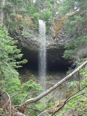
Super short canyon with a pretty awesome aerial rappel into a basalt amphitheater. Best done in Spring when other canyons flow too high, can easily combine with Devils Creek Canyon on the same day.
Approach
From the parking follow an established trail for a short distance to an excellent camping spot and viewpoint of the big waterfall (R1)
Descent
R1: 125' (from tree - free hanging rappel - leave no webbing behind)
R2: 30' (from rock in streambed)
Exit
While the beta on canyoneeringnorthwest.com mentions 2 waterfalls and following the stream downstream, it is much better to scramble up on canyon right after the second rappel to find a use trail that will take you back the top of the first rappel, where you can retrieve the anchor materials you used before going back to the car.
Red tape
There is excellent camping at 47.0072, -121.1569.
Beta sites
Trip reports and media
Background


 CanyoneeringNorthwest.com (archive.org) : West Quartz Creek