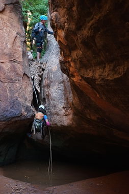
Aardvark Canyon (North Fork)
| Rating: | |||||||||||||||||||||||||||||||
|---|---|---|---|---|---|---|---|---|---|---|---|---|---|---|---|---|---|---|---|---|---|---|---|---|---|---|---|---|---|---|---|
| | Difficulty:3B III (v3a2 III) Raps:5-6, max ↨140ft
Red Tape: Shuttle:Optional but Recommended - 15 Vehicle:4WD - High Clearance | ||||||||||||||||||||||||||||||
| Location: | |||||||||||||||||||||||||||||||
| Condition Reports: | |||||||||||||||||||||||||||||||
| Best season: | Spring or Fall
|
||||||||||||||||||||||||||||||
| Regions: | |||||||||||||||||||||||||||||||
Introduction[edit]
Approach[edit]
Using a car shuttle for this route will save 1.7 miles of hiking. High-clearance 4X4 is recommended for both vehicles.
The approach for this canyon takes 2.5-3 hours and provides stunning views from the top of the Wolverine Bench.
The crypto on top of the mesa is pristine, please do your best to avoid walking across it.
Descent[edit]
Exit[edit]
Red tape[edit]
Beta sites[edit]
 Super Amazing Map : Aardvark Canyon - North Fork
 Climb-Utah.com : Aardvark Canyon
Trip reports and media[edit]
https://www.canyoneeringusa.com/rave/aardvark-canyon-oct-2005
10/8/17: : North Fork of Aardvark Canyon
10/15/17: Both Forks, 8.5 hours car-to-car, group of 3, wetsuit not recommended, some optional R stemming. Doing either fork alone has a high pay-to-play ratio due to the long drive, long approach hike and short technical sections and is not really worth the effort. Either fork is 3-star but done together it is a 4-star day. The approach to the South Fork drop in is about 2.5 hours. The technical section of South Fork was 2 hours and involved about 6 to 8 short stemming sections, no rappels (if exited to descend Naardvark), no swimming, knee deep water depending on stemming skills. You can exit South Fork about 600 feet before the confluence and go up a ramp from an alcove to the plateau then head straight to the North Fork drop in. North Fork had two rappels up to the confluence, a half dozen pools, most of which can be stemmed over but two required swims, and took about one hour. At the confluence there is one rappel. The exit hike to the wash is about 15 minutes. Park: 37.8025, -111.26056. Leave Wash and Hike Up Crack: 37.7858, -111.26889. South Fork Drop In: 37.80394, -111.23855. Exit Up Ramp from South to North: 37.8034, -111.25155. North Drop In: 37.8095, -111.24440. Confluence: 37.80361, -111.25362.
