Adams Creek Gorge
| Rating: | |||||||||||||||||||||||||||||||
|---|---|---|---|---|---|---|---|---|---|---|---|---|---|---|---|---|---|---|---|---|---|---|---|---|---|---|---|---|---|---|---|
| | Raps:4, max ↨80ft
Red Tape:No permit required Shuttle:None Vehicle:Passenger | ||||||||||||||||||||||||||||||
| Location: | |||||||||||||||||||||||||||||||
| Condition Reports: | 10 Oct 2025
"Sent Adams. Added a bolt DCR to break up the rap so that you can make it to the bottom with 50… need to scramble left to make that work. New bolts a |
||||||||||||||||||||||||||||||
| Best season: | Sep-Oct
|
||||||||||||||||||||||||||||||
| Regions: | |||||||||||||||||||||||||||||||
Introduction[edit]
Adams Creek Gorge is a short but very scenic slot canyon in the Adams Creek drainage on the north side of Mt. Adams. The creek drains the Adams Glacier and flows high nearly year round. It features numerous potholes and hydraulics that deserve special attention and respect.
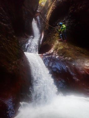
The canyon offers vibrant, moss-covered walls juxtaposed against dark, sculpted rock. The highlight of the descent is a small section of the slot where the creek dramatically narrows, drops, and curves sharply to the right, forming a chain of three incredibly scenic waterfalls. The first of these drops into deep potholes with a hydraulic and the second is shallow with rockfall debris.
Adams Creek is best for advanced canyoneers wanting to test their swiftwater skills and cold water stamina. Lowest yearly flows have been observed during cool, dry periods from September to October.
Approach[edit]
Adams Creek Gorge can be approached from either the east or the west via High Lakes Trail #116.
West Approach from Chain of Lakes Campground: This approach is slightly longer with a steeper approach/exit, but saves about one hour of round-trip driving to the eastside approach if coming via Takhlakh Lake. The downside is that you will not be able to see the flow at the bridge. The trailhead begins where the road ends at 46.2938, -121.5954. Follow the trail down the hillside for 1.6mi until you hit Adams Creek. The canyon is upstream of this crossing, and you will need to cross to continue the approach via the trail (as of 2018 the bridge here has been washed away in a flood and has not been rebuilt). If the creek looks too high to easily cross, consider turning back, as the canyon is unlikely to be runnable. Once across the creek, continue along the trail for 0.35mi. Leave the trail at 46.3015, -121.5797 and continue southeast for 0.25 miles until you reach the drop in (46.2989, -121.5768). This way will NOT allow group to check the flow of the main channel at (46.2691970, -121.5703266).
East Approach from Horseshoe Lake Campground: This approach is slightly shorter with a more gradual approach/exit. Road conditions to get here may vary. Very low clearance vehicles may have difficulty reaching the campground. From the parking lot (46.3101, -121.5673), traverse around the lake to the north and find the trail. Hike down approximately 1.45mi. Leave the trail at 46.3015, -121.5797 and hike southwest until you reach the drop in (46.2989, -121.5768). This route will allow you to check the flow of the main fork at (46.2691970, -121.5703266).
As of 2019, #116 trail shown on some USGS maps is inaccurate. The trail was redone at some point and follows a new path. The KML for this canyon is accurate to the new trail.
Descent[edit]
MAIN SECTION
Note: This canyon utilizes unlinked bolt anchors. Please do not add webbing to these bolts! This canyon sees very high floods and debris can catch on linked anchors and severely damage them. Groups should be familiar with rigging from unlinked bolts.
The creek descends into the main gorge just after a 90 degree turn in the creek at 46.2989, -121.5768.
R1: 80’ from a tree at the rim. You can continue rappelling down the 6' drop just after you enter the canyon. New bolt added at the 6’ drop DCR. Now you can rappel down 50’ from the tree and get to the creek with a small down climb.
R2: 30' DCR - bolts to deep pool with log that you can land on and utilize to get to the newly installed bolts DCL. 2 stages. Anchor manager can judge length. R3: 80' DCR - bolts (the Boiler Room rappel): This is a multi-stage rappel with three consecutive pools, the first one ominously named the "Boiler Room". The canyon takes a sharp turn to the right after this pool. This rappel is the crux of the canyon. Notable risks include hydraulics in high flow and direct pour-overs into each pool that can be difficult to navigate. Rope retrieval is not ideal from this anchor but if stuck then you could retrieve after running the canyon. You do not need a rope for the rest of the canyon. Bolt has been added behind pool 2 to assist with getting out.
Stage 1: 25'
Stage 2: 12' Pool is clear of rockfall and deep. Strongest swimmer should go first.
Stage 3: 6' pool is shallow with break off.
WARNING! About 20 yards downcanyon from the last pool on R3, there is a siphon where the creek pinches and dives under a boulder in a narrow slot about 2.5ft wide. As of 10/17/2020, the siphon was roughly 6 feet deep with a bottom of glacial silt. In high water, the flow was extremely forceful with output funneling through a small hole. Avoid getting in the water here. Exit the previous pool DCL and stem over the slot. As of 9/25/21 there is a nicely jammed log that helps avoid this hazard. As of 10/10/25, original log is there and another was placed to assist.
Continue about 100yds through multiple pools/downclimbs until the canyon opens up and logjams begin to appear. Exit to the right here and hike back up to the trail, or traverse along the creek to the lower section.
BONUS LOWER SECTION
If you have time and energy, you can continue down about 0.2 miles to a bonus mini-slot (hike beside the creek in the timber to avoid the numerous logjams). Though this section is barely 100ft long, the water has carved a neat little hallway here with a scenic series of pools. Fix a rappel line 15-20' off of any nearby tree or log. The rest of the pools can be downclimbed. Exit, hike back up and retrieve your rope in under 10 minutes. Hike back to the trail from here.
Exit[edit]
Follow the High Lakes Trail #116 back to your chosen trailhead.
Red tape[edit]
No fees or passes required for parking/hiking at either trailhead.
Beta sites[edit]
Trip reports and media[edit]
Photos from first descent in Oct 2018: https://www.facebook.com/barry.specht/posts/10218088329026818
More photos from first descent in Oct 2018: https://www.facebook.com/groups/pnwcanyoning/permalink/10156737485905789
Photos from Oct 2020: https://www.facebook.com/groups/pnwcanyoning/permalink/10158800068140789
https://m.youtube.com/watch?v=JaQD72yzs_w
Background[edit]
Canyon scouted by Jake Huddleston in July 2018. First descent by Ryan Ernst, Haruka-James Clay Lipscomb, Barry Specht, and Kevin Steffa in October 2018.


