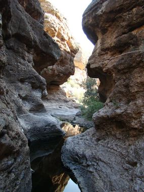
Apache Trail Canyon
| Rating: | |||||||||||||||||||||||||||||||
|---|---|---|---|---|---|---|---|---|---|---|---|---|---|---|---|---|---|---|---|---|---|---|---|---|---|---|---|---|---|---|---|
| | Difficulty:3B II (v3a2 II) Raps:1-3, max ↨30ft
Red Tape:No permit required Shuttle:Optional 5min Vehicle:Passenger | ||||||||||||||||||||||||||||||
| Start: | |||||||||||||||||||||||||||||||
| Parking: | |||||||||||||||||||||||||||||||
| Shuttle: | |||||||||||||||||||||||||||||||
| Condition Reports: | 13 Oct 2025
"Great time, ran right after a large rain storm and had fun flow. All anchors are in good shape |
||||||||||||||||||||||||||||||
| Best season: | Oct-Apr; BEST in Oct, Nov, Mar, Apr
|
||||||||||||||||||||||||||||||
| Regions: | |||||||||||||||||||||||||||||||
Introduction[edit]
A short but high value Superstition Mountains canyon. Some sites offering beta for this canyon describe scrambling around to drop into the canyon below the narrows, but many will prefer the short rappel directly into the narrows (as they are a highlight of the canyon).
Approach[edit]
Descend from the road a short distance down into the drainage and follow it to the first rappel.
Descent[edit]
The first drop is into a deep pool. Note: during drought conditions this pool is capable of producing a bright green layer of toxic algae, consider avoiding the pool if this is the case. A couple more swims and wades will be encountered before the narrows ends, as well as a moderately challenging downclimb below a chockstone where some may want the assistance of a rope.
The remainder of the canyon is mostly easy hiking and scrambling around and in between large boulders (which have created interesting cave-like obstacles). One obstacle in particular is more challenging and due to exposure many will opt to rappel.
The canyon has the capacity to hold quite a bit of water and floods often move around debris, but generally after the narrows section only a few deep wades will be encountered.
In the summer, the section beyond the narrows may be nearly completely dry.
Exit[edit]
Follow the KML track to gain the ridge and hike back to the road.
Red tape[edit]
Beta sites[edit]
 Super Amazing Map : Apache Trail Canyon
 ToddsHikingGuide.com : Tortilla Flat Canyons
 CanyonChronicles.com : Apache Trail Canyon
 HikeArizona.com : Apache Trail Canyon
 onropecanyoneering : Apache Trail Canyon
 ZionCanyoneering.com : Apache Trail Canyon
 AmericanSouthwest.net : Apache Trail Canyon; Arizona
 SummitPost.org : Apache Trail Canyon
 WildPathsAZ.com : Apache Trail Canyon
