Arapaho Creek (Front Range)
| Rating: | |||||||||||||||||||||||||||||||
|---|---|---|---|---|---|---|---|---|---|---|---|---|---|---|---|---|---|---|---|---|---|---|---|---|---|---|---|---|---|---|---|
|
| |||||||||||||||||||||||||||||||
| | Raps:3-4, max ↨65ft
Red Tape:No permit required Shuttle:None Vehicle:Passenger | ||||||||||||||||||||||||||||||
| Location: | |||||||||||||||||||||||||||||||
| Condition Reports: | 8 Aug 2023
"Moderate, generally comfortable flow. Rap 2 has one significant hole in the wall down low and center, that if you rap through, you may get hit with s |
||||||||||||||||||||||||||||||
| Best season: | Jul-Sep
|
||||||||||||||||||||||||||||||
| Regions: | |||||||||||||||||||||||||||||||
_Banner.jpg)
Introduction
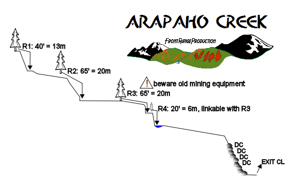
A wet canyon descent with three waterfalls, numerous cascades, and some wading west of the East Portal of the Moffat Tunnel. Natural anchors are abundant.
Best Time Of Year: mid to late summer after spring runoff has subsided.
Note that this canyon lies within the James Peak Wilderness - one of the busiest and most impacted wilderness areas in the entire wilderness system - so please practice leave-no-trace techniques when you visit.
Approach
Directions To The Trailhead: From Boulder Colorado take Canyon Blvd. west. As Canyon Blvd. enters the mouth of Boulder Canyon it becomes Colorado Hwy. 119. Go west on CO 119 to Nederland. At Nederland turn south and continue on CO 119 to the town of Rollinsville. Turn west at Rollinsville and follow the Rollins Pass Road to parking at the East Portal of the Moffat Tunnel.
Approach And Entrance: From the parking lot at East Portal the trail starts from the northwest corner of the parking lot and goes over the East Portal of the Moffat Tunnel. The trail follows South Boulder Creek heading toward Arapaho Lakes and Heart Lake. The trail is fairly flat. After about one half mile the trail crosses Arapaho Creek coming in from the right. Strike through the trees on worn trail just east of Arapaho Creek and west of another smaller waterflow. The trail goes through an open meadow and begins climbing the steep hillside through the trees up the east edge of the gorge. All waterfalls and obstacles can be scouted from this approach. The first waterfall starts at just above the 9600' contour. The canyon is escapable in both directions along most of its length.
Descent
Safety Concerns: High runnoff in early season is a serious safety concern. Be aware of unstable log jams and historic mining equipment from the 1800's at the third drop.
Nearby Rescue Resources And Agencies: Boulder County Sheriff's Department.


Exit
After the final descent of downclimbing, exit the gorge on canyon left, regain the trail, and return to your car at the East Portal. Continuing downstream is too bushy and full of vegetation to walk through in the creek.