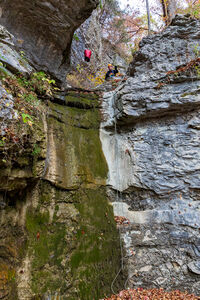
Armadillos Escondidos (Lost Valley)
| Rating: | |||||||||||||||||||||||||||||||
|---|---|---|---|---|---|---|---|---|---|---|---|---|---|---|---|---|---|---|---|---|---|---|---|---|---|---|---|---|---|---|---|
| | Difficulty:3A II PG (v4a1 II) Raps:2-5, max ↨50ft
Red Tape:No permit required Shuttle:None Vehicle:Passenger Rock type:Limestone (Boone Formation) | ||||||||||||||||||||||||||||||
| Location: | |||||||||||||||||||||||||||||||
| Condition Reports: | 26 Oct 2024
"The three falls you’ll descend in the westerly hollow are called “Armadillo Falls” by the waterfall photographing community. The more easterly o |
||||||||||||||||||||||||||||||
| Best season: | Spring/Fall
|
||||||||||||||||||||||||||||||
| Regions: | |||||||||||||||||||||||||||||||
Introduction[edit]
Loop hike in the Lost Valley that descends two tributaries to Lee Creek that feature nice waterfalls in the Boone Formation.
Approach[edit]
From the parking lot, head west on the Lost Valley Trail. At 36° 0'37.83"N, 93°22'35.99"W, leave the trail, cross Lee Creek, and begin the slog up the slope on the other side. (If you reach the natural bridge over Lee Creek before you leave the trail, you’ve gone way too far). Over the course of the next 0.3 miles, you’ll gain about 350 feet of elevation. Where you leave the trail, you’re in the St. Joe Limestone; as you head upslope, at around 1100’ of elevation, you’ll leave the St. Joe Limestone and pass into the “Main Body” of the Boone Formation, which is a grayish limestone that hosts lots of caves (and occasionally forms nice waterfalls). You won’t notice the transition between these layers because it is indistinct and buried under leaves and soil on the slope. As you head uphill, you’ll parallel a hollow on your left; stay on the ridge line and out of the hollow until about 1450’ of elevation. Then, drop into the hollow and aim towards 36° 0'48.77"N, 93°22'32.74"W.
Descent[edit]
Once at the bottom of that drainage, proceed downstream. At around 1380’, you’ll encounter a nice multi-tiered waterfall in the Boone Formation. To descend, we built a retrievable anchor from a cedar on creek right and rapped double-stranded with a 200’ rope. The total vertical height of the drop is probably around 50’ but there are a series of horizontal ledges along the way that eat up rope.
Keep your gear on, there are a couple of drops that you’ll quickly encounter downstream. Shortly after the first drop, we used a handline to help bypass a small fall, which is quickly followed by another drop that is most easily passed by rappelling. The second rappel is only about 20’; it is undercut from the start and cannot be downclimbed. We built a retrievable anchor from a tree on the left side of the creek and rapped double stranded. Because it’s undercut, the start to the rappel is awkward.
Cross to the slope on the west side and head back uphill generally to the north-northwest towards 36° 0'54.16"N, 93°22'42.03"W. Then, change your bearing to be more westerly, aiming towards 36° 1'1.89"N, 93°22'52.69"W, which is around 1580’ of elevation and in the next target hollow. Along the way up slope, you’ll cross a barbed wire fence, which probably marked the old boundary of the Lost Valley State Park. It’s ok to cross the fence, the park was ceded to the National Park Service in 1975, and the other side of the fence is also managed as part of the Buffalo National River.
Once in the target hollow, head downstream and you’ll quickly encounter the barbed wire fence again and a spring that generates a trickle of water that then flows into a shallow slot in the creek bed. You can walk alongside the slot and keep your feet dry. The slot deepens gradually and funnels water over a ⁓40’ waterfall. This fall is informally known as Upper Armadillo Fall. Supposedly, there is a way to bypass it, but we did not attempt to do so. To rappel, we rigged an anchor from a tree on creek right and rapped single stranded. The anchor was set 30ish feet back from the edge and eats up rope.
Once down, spend some time looking around and you will find a couple of caves to explore up the slope on creek left. When you’re done poking around, proceed to the next fall (aka Middle Armadillo Fall), which is only a few yards away. We descended it double stranded from a retrievable anchor. If the creek is flowing, you’ll probably notice water coming out of a small cave just below the lip of the fall. Pull your rope and go on to the short final fall (⁓20’) (aka Lower Armadillo Fall). You can probably bypass it by going down a scree slope on creek right, but we elected to rap it double stranded from a retrievable anchor built around a large boulder in the creek bed on the right side. This fall is also undercut. Below the lower fall is a photogenic alcove and tall cliff on the left.
Downstream, another small, but easily bypassable, fall exists, which is then followed by an undercut alcove on creek right.
Exit[edit]
Carefully stash your technical gear so that it’s not visible to the casual hiker (or ranger) that you might encounter on the way back to the car. From the lowest (bypassable) falls, it’s a 20-minute boulder hop and scramble down to Lee Creek and the trail that heads back to your car.
For a longer hike, turn right on the trail and enjoy scenic Lee Creek, Cob Cave, Eden Falls, and Eden Falls Cave.
Red tape[edit]
Despite popular perception, Lost Valley is not an Arkansas State Park; it is managed by the National Park Service as part of the Buffalo National River. As long you do not place bolts, which are prohibited in the BNR, there are no restrictions on rappelling. Please use only retrievable anchors so that no trash is left behind.


