Ashton Canyon (Main Fork)
| Rating: | |||||||||||||||||||||||||||||||
|---|---|---|---|---|---|---|---|---|---|---|---|---|---|---|---|---|---|---|---|---|---|---|---|---|---|---|---|---|---|---|---|
| | Raps:8, max ↨170ft
Red Tape:No permit required Shuttle:None Vehicle:Passenger | ||||||||||||||||||||||||||||||
| Start: | |||||||||||||||||||||||||||||||
| Parking: | |||||||||||||||||||||||||||||||
| Condition Reports: | 29 Aug 2025
"Beautiful canyon with quality rappels, very nice scenery.. Approach starts up about 2 miles of easy walking trail through the woods. Being from th |
||||||||||||||||||||||||||||||
| Best season: | Aug-Oct
|
||||||||||||||||||||||||||||||
| Regions: | |||||||||||||||||||||||||||||||
Introduction[edit]
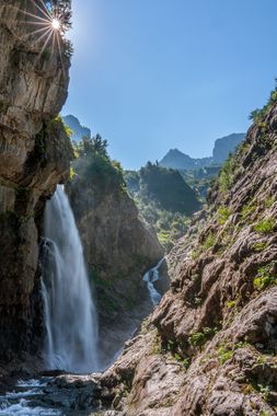
Rooster, Rooster, Rooster, PEACOCK! Ashton Canyon is packed full with big drops and rooster tails galore. It's set in a beautiful basin encompassed by more waterfalls and will likely check most of the boxes of what most canyoneers want in a canyon. Most rappels in this canyon require the use of a traverse line and require side stepping the waterflow. The canyon also uses v-threads & petzl pulse holes for anchors -- be sure to read the caution notes and beta. In the couple of years since the canyon was opened the bushwack section of the approach has improved, with a faint route to follow through the cut-back vegetation.
Snow Pack[edit]
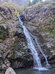
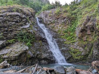
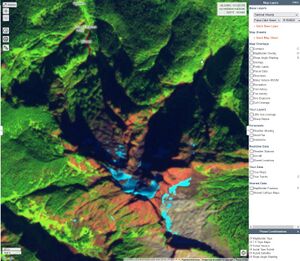
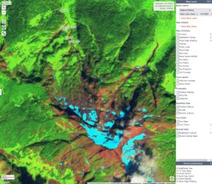
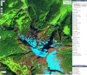
The highlight features of this canyon are dependent on the flow. Early in the season special aquatic hazards will exist. Late in the season the canyon will still be fine to run, but the highlight features will be missing. The reference photos below are from satellite imagery of the drainage above Ashton. These images come from the "Sentinel Weekly" layer of Caltopo. The images are displayed using the "false color green" filter in order to distinguish snow (light blue) from cloud (white). If you don't have a paid-for caltopo account, you can also browser the imagery on the Sentinel Hub.
Approach[edit]
Drive: From Darrington, drive west on State Route 530 for 5 miles. Take a left (traveling south) on 387th Ave NE (convenient gas station & store on the corner) and drive for 0.5 miles until the paved road ends. Take a sharp right turn onto a dirt and gravel road, it may feel like someone's driveway, but continue a short distance until you reach the Neiderprum Trailhead [48.25949, -121.70892]. The parking area can easily fit 5-7 cars.
Hike: Follow the well established trail for 2 miles until you reach an old limestone mine on the right (worth exploring on the way back), and Ashton Creek on the left. The water flow reference picture is taken here. From the stream bed, look right for a faint trail leading up the stream. As the trees thin out your eyes will be drawn upwards to the sub-peaks of Whitehorse Mountain, their slopes littered with streams & waterfalls. The stream bed will lead you to the base of Ashton Canyon, and the foot of R8. Enjoy the buffet of thimble berries and the largest salmon berries you've ever seen.
Top Tip: leave some beverages to cool in the pools here, and enjoy them upon your victorious competition of the canyon before the mellow hike out.
Bushwhack: Scramble up the rock slabs to the left (looking upstream) until you reach the top of R8. Proceed uphill into the brush following a faint semi-established route, until you reach the cliff band. Follow the cliff to the right with the aim of reaching a boulder field that is visible via satellite imagery. At ~1,780' elevation, make your way down through the brush to reach the top of the first rappel. There is ample room to suit up here.
Descent[edit]
CAUTION:
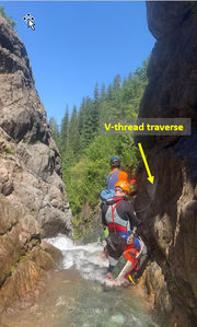
- Do not underestimate the technical rope work and team sequencing needed for this canyon. Your entire team should be comfortable navigating rooster tails and water chutes in slippery conditions. Rope and pack management are important. Belays are not always possible. Be sure to check pool depth for hazards (e.g. logs, boulders, and shallow pools) prior to sliding and jumping.
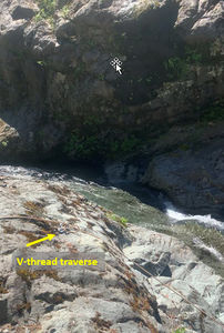
- This canyon utilizes v-threads (aka rock threads) for traverse line anchors and rappelling anchors. Treat these as marginal anchors and use appropriate techniques to back them up (e.g. human anchors, removable bolts, etc). The cordage is made from 5 mm pure dyneema and tied off using a triple fisherman's bend. The 8 mm Petzl pulse can be used for the backup removable bolt.
- There are traverses in the canyon which should be rigged for retrieval via self-belay or team belay techniques. Do not leave fixed lines in the canyon.
R1 + traverse:
- Traverse: 10’ DCL from small tree. Utilize a traverse line to reach R1 -- the floor is unstable and it is easy to accidentally dislodge rocks.
- Rappel (R1): 170’ DCL from v-thread. The v-thread can be backed-up using a removable bolt. Be careful of an abrasion point on the 2nd lip (15-20ft down), very sharp.
R2 + traverse:
- Traverse: DCR 10' from bolted traverse line anchor
- Rappel (R2): DCL 130' from v-thread. The v-thread can be backed-up using a removable bolt
R3 + traverse:
- Traverse: DCR 15' from v-thread. The v-thread is at ground level in the center of the canyon
- Rappel (R3): DCL 110' from unlinked bolts. In higher flow, the rooster can be side-stepped from DCL to DCR
R4: DCL 25' from v-thread. The v-thread can be backed-up using a removable bolt
R5 + traverse:
- Traverse: DCR 10' from v-thread traverse line anchor
- Rappel (R5): DCR 50' from v-thread. The v-thread can be backed-up using a removable bolt. This waterfall concentrates into a funnel and ends in a turbulent pool. In higher flow the water is stronger on DCR and in the center of the pool so landing in the calmer water (DCL) is a more pleasant experience.
R6: DCL 15' from v-thread (The single bolt should not be used. It was damaged in winter 2022/23 and has been left in place to serve as a side-by-side survival test with a v-thread). Alternatively a 10' very shallow jump from chockstone.
R7: DCR 60' from single bolt. The waterfall forms an impressive S-shaped rooster tail which can be done as a sporty rope slide. This waterfall can be bypassed on canyon left.
R8 + traverse: This waterfall can be bypassed.
- Traverse: DCL 10' from v-thread traverse line anchor
- Rappel (R8): DCL 90' from v-thread & single bolt. This isn't an ordinary rooster tail, this is a damn peacock tail. The water concentrates about 15' down -- jump over this (in whichever way you are able) to DCL and prepare to be engulfed inside the most impressive waterfall bubble. In higher flows a rooster tail forms inside the peacock tail.
Exit[edit]
Eat more berries. Proceed downstream and follow the faint trail DCL until you reach the main trail. Walk the 2 miles back to your cars.
Red tape[edit]
None
Beta sites[edit]
Trip reports and media[edit]
https://www.facebook.com/groups/pnwcanyoning/posts/10160145777245789
Background[edit]
Ashton Canyon was first descended on July 30, 2022 by Andrew Humphreys, Jake Huddleston, Kevin Steffa, Mike Peterson, Ryan Ernst, Haruka-James Lipscomb and Tiffanie Lin. We found webbing near R1 -- perhaps left from ice climbers or are a very secretive canyoneer. While the rest of Seattle baked in 90F+ weather, Ashton was the perfect retreat from the heat and might be the one of the few (if only) times where the water temps weren't freezing in the PNW.
