Askotxi Canyoneering Canyoning Caving descenso de barrancos Barranquismo
Also known as: Barranco Askotxi.
|
| Rating: |
Log in to rateLog in to rateLog in to rateLog in to rateLog in to rate 0.0 (0 ratings) |
|
|
| |
Raps:max ↨75ft | Overall: | 2.5h | |
|---|
| 5min | | | | 2h | ⟷1.1mi | ↑869ft | | 15min | | |
No Shuttle:Optional Rock type:Limestone |
|---|
| Location: |
APPROXIMATE LOCATION! |
|---|
| |
|---|
| Condition Reports: |
26 Dec 2016? "extracts from Facebook posts, click link for full details (privacy restrictions may apply). " Hemos ido hoy al barranco de askotxi en l gorbea y n
(log in to submit report)
|
|---|
Weather: |
|
|---|
| Best season: |
Anytime | winter | | spring | | summer | | fall |
|---|
| Dec | Jan | Feb | | Mar | Apr | May | | Jun | Jul | Aug | | Sep | Oct | Nov |
|
| Regions: |
|
http://barranquismo.net/paginas/barrancos/barranco_askotxi.htm,http://www.docuwiki.infobarrancos.es/doku.php?id=barrancos:vizcaya:askotxi
estopo
GPS data automatically extracted from [], please visit their site for more detailed information.
Automatic GPS data extraction NOT allowed, please visit [] to download GPX.
Introduction
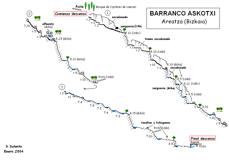
Acceso desde: Areatza - Villaro(Bizkaia)
Altura de rápel mas largo: 23 m
Información del caudal: Caudal dependiente de la estación del año
Material necesario: 2 de 30 m
Neopreno: En invierno, peto
Material de instalación: Aconsejable llevar material de instalación de repuesto
Epoca: Todo el año
Horario de aproximación: 5 minutos
Horario de descenso: 2 horas
Horario de retorno: 15 minutos
Mapa: MTNE 1:25.000 ELEXALDE 87-I
Zona o macizo: Macizo del monte Gorbea
Cuenca: Nervión
Altura en inicio: 735 m
Altura en final: 470 m
Longitud: 1.800 m
Desnivel: 265 m
Carácter: Al comienzo encañonado, luego abierto
Tipo de roca: Caliza
Combinable con el descenso de: Bco. Ursalto, Bco. Sintxita, Bco. Alarrieta, Bco. Iritxin
Approach
Combinación de vehículos: Conveniente dejar un vehículo en la parte inferior del barranco y el otro en la cabecera (lugar denominado Larreder)
Desde el municipio de Areatza subir por la pista cementada que se dirige al refugio de Pagomakurre. A unos 800 m de altura en un lugar preparado por el Parque Natural del Gorbea, denominado Larreder, dejar el vehículo. Desde este lugar solo hay que descender a una pista dirección norte y en 5 minutos estaremos en la cabecera del barranco.
Descent
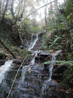
Barranco encañonado y estrecho en los 100 primeros metros de desnivel. Luego de carácter abierto.
Escapes: Es posible abandonar el barranco en casi todo su trayecto
Exit
El barranco finaliza en un puente que cruza una pista que sale a la izquierda, en el sentido de la subida a Pagomakurre (a unos 450 m de altitud). Es conveniente dejar un vehículo en este lugar (ver esquema).
Red tape
.
Beta sites
Trip reports and media
Background
26-Jan-05 DIEGO DULANTO (descendedor)
Primer descenso integral: D.Dulanto, J.Granja, F.Tijero, A.Rekero (Enero 2005). Nota: La primera parte (zona encañonada) fue descendida por primera vez por el G.Espeleológico GAES de Bilbao.


 Barranquismo.net : Askotxi