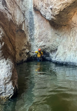
Backyard Canyon
| Rating: | |||||||||||||||||||||||||||||||
|---|---|---|---|---|---|---|---|---|---|---|---|---|---|---|---|---|---|---|---|---|---|---|---|---|---|---|---|---|---|---|---|
| | Difficulty:3B III (v3a2 III) Raps:3-4, max ↨100ft
Red Tape:Permit required Shuttle:None Vehicle:High Clearance Rock type:Volcanic tuff | ||||||||||||||||||||||||||||||
| Start: | |||||||||||||||||||||||||||||||
| Parking: | |||||||||||||||||||||||||||||||
| Condition Reports: | 5 Jan 2025
"One mandatory swimmer. The rock quality is ok and the natural anchors were super good enough. We sent the heaviest person down first with a back up on |
||||||||||||||||||||||||||||||
| Best season: | winter, spring, fall
|
||||||||||||||||||||||||||||||
| Regions: | |||||||||||||||||||||||||||||||
Introduction[edit]
Probably the nearest technical canyon to the Phoenix metropolitan area, Backyard Canyon is a short, but rugged, off-trail canyon route in the beautiful Goldfield Mountains with a few nice rappels and one potential short swim.
From Phoenix, take SR202 to exit at Power Rd. Drive north on Power Rd (turns into N Bush Hwy) for 9.3 miles, then turn right after mile marker 28 onto Phon D Sutton Rd which is also the Bulldog Canyon scenic 4x4 roadway. A free permit (good for six months) is required from the Tonto National Forest, Mesa Ranger District to pass through the gate and drive on this road. The gate to the road is locked; you will get the combination to the lock when you obtain your permit. Once through the gate, drive south on this sometimes bumpy, but well maintained dirt road for 1.9 miles to park at a pullout and campsite on the left at a pair of power line poles.
Approach[edit]
From the parking area, hike southeast down into the sandy wash of Bulldog Canyon and cross to find a rough 4x4 road on the other side of the wash. Follow this road a short distance, then turn right on an even more minor dirt track that will take you to another sandy wash. Follow this wash for about .5 mile to a point where the drainage splits off to the left and take this drainage all the way to the top. You should be able to see the saddle you are heading for for the duration of the route up this rocky, brushy drainage. A few dryfalls can be bypassed on the slope on the left, which is easier to hike in spots than directly in the drainage. This route becomes more and more steep, crumbly, brushy and requires a bit more class 3 scrambling the higher up you go. Once on top, contour around to the east to begin finding your way down the slope and through a steep gully or two before reaching the main drainage of Backyard Canyon.
Descent[edit]
Head left and down canyon. A few easy downclimbs are encountered before reaching the technical section.
R1: 75’ off rock pinch into the narrows.
R2: 40’ off rock pinch into a deep pool. Mostly wading, though the middle is deeper and at times a short swim may be required.
R3: 20’ immediately after the pool. Use R2 anchor and continue down this drop, or meat anchor the group and spot the last person as they climb down.
A few downclimbs will need to be negotiated prior to the final rappel.
R4: 100’ from a cairn in the watercourse, or about 140’ from a rock pinch set back RDC. The rappel is a two-stage drop.
Exit[edit]
Continue hiking and downclimbing down canyon after the last rappel to eventually reach a spot where the canyon opens up and you can easily hike out to the left to begin the cross-country trek back to the parking area. Simply head west following the path of least resistance through the low hills and minor drainages along the way. The sight of the power lines you parked under will help lead the way once you start getting close.
Red tape[edit]
Contact information for the Bulldog Canyon permit can be found here: https://l.facebook.com/l.php?u=https%3A%2F%2Fwww.fs.usda.gov%2Fdetail%2Ftonto%2Frecreation%2Fohv%2F%3Fcid%3Dstelprdb5348179&h=ATPG_jwMclLWN584AudCHMXaA7_yQd9d-nxl8d7Zrp5ADap1WGIW8cZAdmm6kv7JQESqLcpxk7JYTwIy7TG4PUKvmNJgBiVruAoGaCgqtJqM-8skUER9-zF0z-nCMcFIOpMKuWE91sg8Yfdv8wIMEY8rEy3Gt66_Ko858UinvxNxU63qogl6aA
Beta sites[edit]
 Super Amazing Map : Backyard Canyon
