Big Falls (Southern California)
| Rating: | |||||||||||||||||||||||||||||||
|---|---|---|---|---|---|---|---|---|---|---|---|---|---|---|---|---|---|---|---|---|---|---|---|---|---|---|---|---|---|---|---|
|
| |||||||||||||||||||||||||||||||
| | Raps:2, max ↨170ft
Red Tape:Closed to entry Shuttle:None Vehicle:Passenger | ||||||||||||||||||||||||||||||
| Location: | |||||||||||||||||||||||||||||||
| Condition Reports: | 25 Aug 2024
"We hiked to see the falls from the bottom and the flow looks awesome, even this late in the season. To bad this canyon run is closed. |
||||||||||||||||||||||||||||||
| Best season: | All year
|
||||||||||||||||||||||||||||||
| Regions: | |||||||||||||||||||||||||||||||
_Banner.jpg)
-20141204071617_pic.jpg)
-20141204072733_pic.jpg)
-20190701150416_pic.jpg)
-20141204064726_pic.jpg)
Introduction
UPDATE June 4, 2025: Big Falls closure was renewed as of May 22, 2025, through May 22, 2026. See the updated closure notice and the map.
Current Closure Notice: https://www.fs.usda.gov/sites/nfs/files/r05/sanbernardino/publication/alerts/Big%20Falls%20Area%20Closure%2005-12-53-25-01.pdf
Current Closure Map: https://www.fs.usda.gov/sites/nfs/files/r05/sanbernardino/image/alerts/Big%20Falls%20Area%20Closure%20EXHIBIT%20A.jpg
Monitor this website to stay up-to-date: https://www.fs.usda.gov/r05/sanbernardino/alerts
5-28-2022 - Spoke with a Ranger on location and was told that a new "Closure" was re-issued and would be posting in minutes of that morning of the 28th, 2022. Currently there are no online posting that can be found regarding this continuation of closure and both online and physical posts may show up at different times so always check for both. It may take a few days from now for any of these orders to show up in public. Fines were verbally expressed upon violation by the Ranger on site. If and when the physical post is published on location a photo of it should be posted here.
10-26-2017 - Contacted Mill Creek Ranger Station and they confirmed that Big Falls can now be descended.
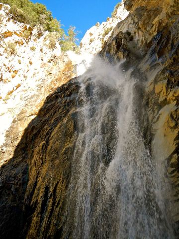
Big Falls is a series of 2 large waterfalls in the San Bernardino Mountains. Although given an A rating, the flow for these are some of the highest you'll find year round in Southern California. Wetsuits or waterproof jackets are typically required in winter and spring due to the cold water temperature and alpine location.
Approach
Hwy 38 east from Redlands, fork right onto Valley of the Falls Road, drive through the hamlet of Forest Falls. Just past the ranger shack in the road make a left into the Big Falls Parking lot and park here. The trail begins on the north side of the lot heading west.
Take the Big Falls Trail from the parking lot to the usual tourist overlook. After crossing Mill Creek (currently a dry riverbed but it has been known in wetter years to be a swift and tricky river crossing) and upon reaching the mouth of the canyon proceed to the viewing platform (a metal fence from where people look at the falls) by following a trail on the east side of the canyon. The platform is not a good checkpoint from where to inspect the water flow because the lower fall is not visible, so it is better to proceed ahead for a little distance till the lower fall comes in full view. Alternatively you can also check flow once on the ridge hike.
After checking water flow retrace your steps (go back towards the mouth of the canyon) to about 150ft downstream from the viewing platform and cross the river. Look for a climbing trail that starts between two large trees on the west side of the canyon and follow this trail all the way up to the top of the ridge. It's a steep, somewhat loose approach, but it's easily managed and will save hours and unnecessary elevation gain compared to any other approach route. Staying close to the cliff side next to the canyon you will find a faint use trail. When you reach the top of the ridge you will find a well worn trail to drop into the canyon putting you at the top of rap 1. IMPORTANT: Do not try to climb the canyon walls upstream from the viewing platform, these routes are EXPOSED and DANGEROUS, several people have been killed trying to free climb these crumbling walls.
_2trees.jpg)
_climbing.jpg)
_ridge.jpg)
Descent
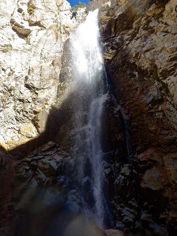
As of Winter 2019 the canyon center (between R1 and R2) has totally changed. All the dirt and talus rocks have been swept away. The huge boulder RDC for R2 is gone. R1 is still off the same big tree, but the drop length is now 170 feet with no option to make it shorter by angling right at the bottom to hit the high dirt ground. There is now a large log wedged across the canyon at the top of R1, which is easy enough to climb over and does not seem to cause any rope pull issues. The high anchor point on the big tree provides easy pull. The plumb line from this tree will soon move you out of water course onto a slick rock face RDC. In high flow, the tricky part is relatively short, a bit below the big log where you have no choice but go through heavy water flow. Touchdown is at the edge of the pool.
R1 can be rigged LDC either off a reasonable bush or rock horn. You have to cross the stream up high and traverse out onto the exposed skinny ledge to reach these anchor points. These anchor points keep you out of the water course initially, but soon you will be in the full brunt of it midway to mostly down. This good fun in low flow, but could be dangerous in high flow. Normally no webbing will be found at either of these locations, so you will have to build your own anchor here.
Winter 2019 storms swept away the old R2 anchor boulder and all the other rocks and dirt mid canyon. R2 is now webbing looped around a buried rock RDC that is approximately where the old boulder anchor was located, but vertically lower. This anchor has a courtesy rappel point (red webbing at 115 feet) and an extended rappel point (tan webbing 100 feet). The courtesy rappel point is easy and safe for people to get onto rappel (unlike the old boulder), but the rope pull (even with no block or knot) is so bad that you cannot retrieve your rope. So the last person needs to use the extended rappel point, which requires rappelling to that point, then changing the rope anchor point. There is a reasonable ledge for standing at the extended point, but it's dangerous to stand there without being connected to the extended anchor with a safety tether. From this anchor, the rappel skirts the edge of the water flow (high flow) so it's generally easy to get to the bottom without being hammered by water too much.
R2 can be rigged with webbing around a large boulder centered in the water course. This will put you into the main brunt of the waterfall, which like R1, is good fun in low flow, but could be dangerous in high flow.
The water temperature is quite cold for SoCal, and canyoneers have experienced "brain freeze" with the water pounding on their exposed necks even using wetsuits. A wetsuit hood is HIGHLY recommended!
_BigFallsR1anchor.jpg)
_RIMG3866.jpg)
_RIMG3870.jpg)
_RIMG3875.jpg)
_RIMG3881.jpg)
_RIMG3888.jpg)
First rappel, 170' off a high anchor on a solid tree RDC into the pool (Note: winter 2019 removed all the dirt and rocks for the shorter 150 to 160 feet rappel option)
Second rappel, 115' from new 2019 courtesy rappel point RDC (Note: that a 200ft double strand rope will make the bottom from the extended rappel point, but not from the courtesy point)


Exit
A short and easy scramble RDC. Find a place to cross the stream and rejoin with the Big Falls Trail.

Red tape
Booth at Big Falls parking lot is manned by a ranger during operating hours.
Requires Forest Adventure Pass for parking.
No adventure pass required if you park on the street at the approach.
Access to Big Falls is closed starting July 4th, 2019, and has been renewed in 2020, 2021, and 2022. Signed forest order and map of closure below.
_pic1.jpg)
_pic2.jpg)
_pic22.png)
Beta sites
 Chris Brennen's Adventure Hikes (Southwest) : Big Falls