Blanche (Piton Dumauze)
| Rating: | |||||||||||||||||||||||||||||||
|---|---|---|---|---|---|---|---|---|---|---|---|---|---|---|---|---|---|---|---|---|---|---|---|---|---|---|---|---|---|---|---|
| | Raps:21, max ↨148ft
Red Tape:No permit required Shuttle:Optional 4 km Vehicle:Passenger | ||||||||||||||||||||||||||||||
| Start: | |||||||||||||||||||||||||||||||
| Parking: | |||||||||||||||||||||||||||||||
| Shuttle: | |||||||||||||||||||||||||||||||
| Condition Reports: | 1 Jan 2023
"Trail in good shape, all anchors look excellent. Perfect flow. If higher, more challenging! AMAZING canyon. Went with Thierry Monges, and his knowledg |
||||||||||||||||||||||||||||||
| Best season: | Any, AVOID rains
|
||||||||||||||||||||||||||||||
| Regions: | |||||||||||||||||||||||||||||||
Introduction[edit]
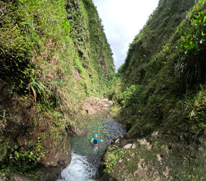
Blanche (Piton Dumauze) is one of the better routes on Martinique. Expect a stunning approach, some fairly big rappels, a canyon where flow picks up as it continuously narrows, and jumps, jumps and more jumps! This one shouldn't be missed.
Approach[edit]
From the parking area, cut up the grass slope on the right and into the forest. There is a trail here that is generally easy to follow. The vegetation is thick, however, and long sleeves and pants are a good idea. The trail winds up steeply.
Use the gps track on this page. The page continually goes up, soon breaks out of the forest, and has spectacular views. Soon after a short downclimb with a fixed rope, you'll have to turn right onto a smaller trail. This point is nondescript - use the gps for help. The trail continues going up, up, up from here.
After the trail goes up the ridge a ways, you'll reach an upclimb with the fixed rope. It's not too bad, but most people prefer to tie their packs to the rope and haul them up separately.
After this upclimb is another handline ascent, which is much easier. The trail then improves, though it can be muddy, as it cuts across a saddle with crazy views to a cloud-forest meadow where you can suit up.
Descent[edit]
The descent has around 21 rappels, with a continually increasing flow. There are swims, jumps, downclimbs, slippery boulders, and good to excellent anchors, mostly bolted.
The first series of rappels go up to 25 meters with a small trickle.
The rappels bring you to a unique slanting rappel on a waterfall.
After this, the waterfalls get better, and the swimming pools start.
You'll soon reach the big rap, around 40 meters. This is almost vertical, not overhung, in a shower of water. The bottom is a good spot for lunch.
The canyon joins with Alma shortly after this, and the flow increases considerably, and the canyon tightens. The fun gets better and better!
Some of the rappels are in waterfalls. Many can be jumped, but the rocks are slippery, and the rippling pools are hard to estimate depth. ALWAYS check the pools first.
The walls of the canyon become huge as it funnels you down, down, down. Some drops have fixed handlines.
The last part has another stunning set of jumps which can be handlined or rappelled.
Shortly after the final pool, the canyon opens, the flow seems to drop, and the slot ends. Time to hike the exit out!
Exit[edit]
After the last waterfall, the canyon opens somewhat and appears to be more flat. This is the end of the route. You'll see a visible trail the crosses back and forth. Follow this trail, using the GPS track on this page for guidance. The trail gets better and better, at times with heavy mud, and then comes out the the pavement where you've parked your lower shuttle vehicle.
Red tape[edit]
No red tape.
Beta sites[edit]
 An Kanion La-madinina : Rivière Blanche Dumauzé [PC-17]
 Mur d'Eau Caraibe : Rivière Blanche par le piton Dumauzé
- LukasEddy.com : Canyons of Martinique
Trip reports and media[edit]
Background[edit]
As one of the better routes on Martinique, and also a route that shares its lower half with Alma, this route is commonly run and well-maintained (in general). Anchors are generally in good shape. First descent unknown.


