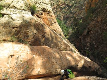
Boltergeist Canyon
| Rating: | |||||||||||||||||||||||||||||||
|---|---|---|---|---|---|---|---|---|---|---|---|---|---|---|---|---|---|---|---|---|---|---|---|---|---|---|---|---|---|---|---|
| | Difficulty:3A I (v3a1 I) Raps:5-6, max ↨150ft
Red Tape:No permit required Shuttle:None Vehicle:Passenger Rock type:Sandstone | ||||||||||||||||||||||||||||||
| Start: | |||||||||||||||||||||||||||||||
| Parking: | |||||||||||||||||||||||||||||||
| Condition Reports: | 13 Oct 2025
"Fairly heavy rain last weekend meant the canyon had several unavoidable knee to waist deep pools. Water to dodge in potholes on the spot of approach t |
||||||||||||||||||||||||||||||
| Best season: | Any
|
||||||||||||||||||||||||||||||
| Regions: | |||||||||||||||||||||||||||||||
Introduction[edit]
A fun short canyon with several rappels and avoidable potholes. It could have water in the early season or after heavy rains, but often dries up in late spring or summer.
- Please remember that Boltergeist is within the Cottonwood Forest Wilderness Area. Recreation in the Area should remain within the bounds of the 1964 Wilderness Act. Permanent fixed hardware should only be installed when necessary and power tool use is prohibited.
Approach[edit]
Special note: The drive from Leeds on the fire road will be tricky if the road is wet and slick.
Park along the dirt road where indicated and follow a social trail a short distance down to the watercourse.
Descent[edit]
Rappel counts will vary as additional anchors have been added depending on the groups skills and conditions.
- R1: 30’ bolts LDC. (May also be downclimbed)
- R2: 60’ Webbing RDC around a pillar. You can down climb a 20-30’ chimney or rappel into the watercourse. Going straight off the end is much harder than going down the crack into the watercourse. There is also a down climb RDC that can bypass everything.
- R3: 70’ tree RDC. Manage ropes to prevent twisting around the corner. Consider having the last rappeller stop just after the overhung section to make the rope pull easy and avoid rock grooves.
- R4: 50’ boulder in watercourse. Tricky start. There are bolts LDC near the lip of the rappel. There are also bolts 10-15 feet above the lip- you need to go back ten feet and climb up to get to them. This eliminates the tricky start and makes getting past the water on the bottom much easier (if it’s there). There is a small ledge to walk along before you get to the bottom and then go off a small tree with a hand line that is usually there. It may also be possible to stem across the water to stay dry, or, set up a guided rappel to keep everyone else dry.
- R5: 120’ tree LDC to first ledge (or continue to the base of the next stage for a 150' rappel). This is a mostly free hanging rap. Mind rope placement at the lip, as deep grooves have developed which could entrap a knot, biner, figure 8, etc. and hinder rope retrieval. Many a rope has been stuck on this rap. To avoid ropes getting stuck and creating deeper rock grooves, consider using courtesy rigging for all but the last person who can lengthen the anchor so the quick link is past the grooves (the edge of the cliff is rounded and is featured, making down climbing while tied off easier).
- R6: 45’ tree in the watercourse (if prior rappel was done as a 120’). Can also walk around on the right.
One last small drop into a pool by the creek can be bypassed LDC or RDC. RDC seems to be more popular as a social trial has developed.
Exit[edit]
After the last long rappel, the sounds of a stream are audible in the trees down canyon. Follow the canyon floor to the small stream and cross it. Turn left and there should be a somewhat visible trail on the far side heading up the watercourse. Follow the trail near the watercourse past many small waterfalls and pools until it crosses back over the stream and pass a shear rock face on the left. Rock cairns mark the way up and the social trial is now much easier to follow but the exit requires significant scrambling and some traversing thin ledges to ascend the steep cliff quickly. Once at the top follow one of the social trails to the left and back to the road which takes you back to the car (stay on trail to avoid damaging biological soil crust (crypto)). It should be less than a 10 minute walk back to the car once on the mesa.
Red tape[edit]
Beta sites[edit]
 BluuGnome.com : Boltergeist Canyon
 RoadTripRyan.com : Boltergeist Canyon
 Climb-Utah.com : Boltergeist
 Zion Canyoneering Book by Tom Jones : Boltergeist
 CanyonCollective.com : Boltergiest
 Super Amazing Map : Boltergiest
 ZionCanyoneering.com : Boltergeist Canyon
Trip reports and media[edit]
 That Adventure Life : Boltergeist Canyon
- https://www.stavislost.com/hikes/trail/boltergeist-canyon
- http://adamhaydock.blogspot.com/2014/09/day-5-boltergeist-canyon.html
 Candition.com : Boltergeist
