Bonilla Canyon
| Rating: | |||||||||||||||||||||||||||||||
|---|---|---|---|---|---|---|---|---|---|---|---|---|---|---|---|---|---|---|---|---|---|---|---|---|---|---|---|---|---|---|---|
| | Raps:6-7, max ↨328ft
Red Tape: Shuttle:Optional 3km Vehicle:Passenger Rock type:Volcanic | ||||||||||||||||||||||||||||||
| Start: | |||||||||||||||||||||||||||||||
| Parking: | |||||||||||||||||||||||||||||||
| Condition Reports: | 17 Mar 2023
"Wonderful day in Bonilla! We were a party of 5 (2 Americans, 1 Swiss, 1 French, 1 Tico), and coincidentally there was another party of 5 Ticos (includ |
||||||||||||||||||||||||||||||
| Best season: | Jan-Apr
|
||||||||||||||||||||||||||||||
| Regions: | |||||||||||||||||||||||||||||||
Introduction[edit]
Bonilla canyon is among the best canyons in Costa Rica and definitely world class quality. It boasts not one but two 100m waterfalls and several other high quality aquatic rappels. This canyon is prone to very heavy water flow and there are also multiple high consequence hand lines to access rappels in this canyon. It should be attempted by well equipped teams with ample swift water experience.
Approach[edit]
Park your car at the bridge that crosses Rio Bonilla. You can then walk next to or in the river for 10 minutes until you reach the hand line for R1
Descent[edit]
The four major waterfalls in this canyon (R1, R2, R3, and R6) are named waterfalls, which locals access via paths from the rim. All of these paths are canyon left, and lead through private farmlands to the exit road.
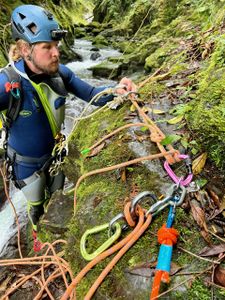
R1 (La Cueva): 7+30m canyon left single bolt allows a hand line to access a single bolt on canyon left around the corner on the edge of the falls. The recommendation is to belay your teammate out here with a rope that will reach the bottom, and not to self belay due to the slickness of the rock in this canyon. If this canyon becomes more popular, adding an intermediate could be valuable for accessing the rappel 1 station.
R2 (La Morpho/La Perla): 12+43m(+ redirect) v thread high canyon left out of the water course provides an access rappel to the double bolt station canyon left hidden behind a flake of rock in the chute. There is a single redirect bolt on canyon left at the edge to avoid the abrasion point and to keep you out of the meat of the flow in high levels. It is required to cross a heavy concentration of flow to access the redirect.
- After R2 there is a small path canyon left that can provide escape from the canyon
R3 (La Bruja):5+100m a double bolt station on canyon right provides a station to belay your teammate out to the double bolts on R3. There is one intermediate point on the hand line. The intermediate needs to be replace as of 1 Feb 2023. We drilled holes for a v thread but dropped the v thread tool during install.. Once at the double bolt, it is approx 100m to the pool below. This rappel will drop you into the flow towards the bottom.
- After R3 there is a path canyon left that leads out of the canyon and can also allow you to bypass the next rappel if you would like.
R4: 10+10m bolt on canyon left provides set up for a hand line to cross a recirculating pool to get to another bolt canyon left to rappel the short falls. Note: this rappel can be bypassed.
R5: 15m there was a log jam canyon left that we used but isn’t guaranteed to be there in the future. The canyon is much wider in this section. There is another drop after this that looks like a possible jump and can be downclimbed around on canyon left.
R6 (Las Nubes):20+100m there are bolts near the ground level on a flake canyon left that provide access to a bolt station over the lip of the drop in the canyon center. These bolts may be difficult to find as they are around some tall grass. Be mindful on this large rappel not to knock down the loose rock that makes up this falls.
Exit[edit]
Exit canyon left through private farmlands. Be sure to ask permission from the farmers first, and offer to pay to pass through their property. The community is very friendly, and members of the Turrialba Canyoning Team @turrialbacanyoningteam can help connect you, and may want to run the canyon with you!
Red tape[edit]
All exits require travel through private farmland. Most of the farmers are very welcoming and friendly, and it’s important to ask permission to pass through their land. Local canyoneers have relationships with the farmers, and its good practice to reach out to them (the Turrialba Canyoning Team @turrialbacanyoningteam) to ask for assistance.
Beta sites[edit]
Trip reports and media[edit]
Background[edit]
First opened by Luigi (Carlos Torres) and teammates from the Turrialba Canyoning Team
2019 complete canyon decent bolted by Johan Aguilar and team from Spain.


