Box Creek Canyon
| Rating: | |||||||||||||||||||||||||||||||
|---|---|---|---|---|---|---|---|---|---|---|---|---|---|---|---|---|---|---|---|---|---|---|---|---|---|---|---|---|---|---|---|
|
| |||||||||||||||||||||||||||||||
| | Difficulty:4B III (v4a2 II) Raps:0-9, max ↨213ft
Red Tape:No permit required Shuttle:None Rock type:Granite | ||||||||||||||||||||||||||||||
| Start: | |||||||||||||||||||||||||||||||
| Parking: | |||||||||||||||||||||||||||||||
| Condition Reports: | 15 Dec 2024
"Water levels where fairly high which made for a fun trip - we were doing training so a bit slower then the average party. An efficient party with whit |
||||||||||||||||||||||||||||||
| Best season: | Oct-Apr
|
||||||||||||||||||||||||||||||
| Regions: | |||||||||||||||||||||||||||||||

Introduction
Box Creek is a sequential series of granite slab waterfalls in the Kanangra Boyd National Park. It's one of the easiest Kanangra canyons and a great option if you want a gentler second day after tackling one the bigger Kanangra canyons.
It's also a great training area for those looking to progress their skills when the water levels are higher.
Water levels
Box Creeks’s catchment is approximately 15 sq. Km.
Water levels can range from a trickle to a pumping cascade. High flow conditions increase the technical difficulty requiring advanced canyoning skills.
Video of the Box Creek in high water level:
Approach
Park at above coordinates (Gillespies Lookout) and walk as per the GPX.
From Oberon, take Edith Road, Kanangra Walls Road, and Kowmung River firetrail. The access road is usually easily drivable for any vehicle that is taken on the Kanangra Walls road.
Do NOT take Shooters Hill Road as per Google Maps. There is private property at the end of Sheepstation Forest Road, and crossing Hollanders / Kowmung River requires a high-clearance 4wd on very steep terrain.
Descent
- Start at the top, go to the bottom ;)
- Escape is possible from almost every drop
- Do not leave tape, rope etc attached to the anchors. With the exception of P1 all anchors have maillons and rap rings.
| Number | Metres | Location | Note |
|---|---|---|---|
| 1 | 30m | RL | Rock thread anchor. Bring sling and maillon/quick link to build own anchor. Remove it on your way out. Sling should not be left on the thread anchor in order to reduce visual impact. |
| 2 | 25m | RR | Rock thread anchor. Bring sling and maillon/quick link incase you need to replace. |
| 3 | 8m | RC | Single bolt in creek floor |
| 4 | 25m | RL | Redirect bolt on the RL wall a few metres down. Useful for when the flow is up. There is also approach bolts for high flow scenarios and getting to anchor is risky. |
| 5 | 20m | RL | |
| 6 | 15m | RR | |
| 7 | 25m | RR | |
| 8 | 8m | RR | |
| 9 | 65m | RR | You can use a 60 metre rope by joining to another similar length rope, extending out the anchor by 5 metres and going single rope. Leave the ropes in place and collect them on the way back up. |
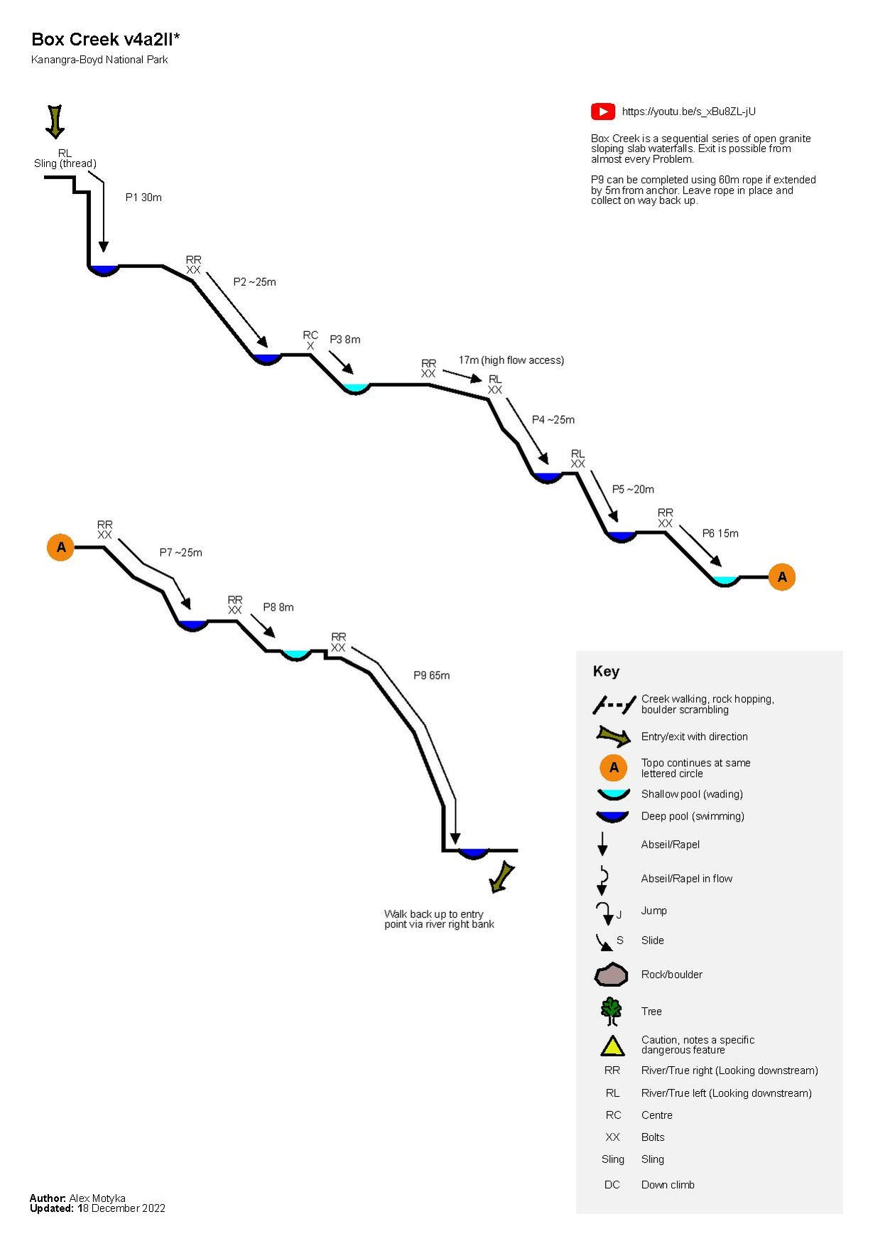
Exit
- Walk back up from bottom of P9 via river right/true right back to start of canyon
- Return to carpark via entry route
Red tape
Beta sites
Trip reports and media
- http://david-noble.net/blog/?p=12499
- https://ozultimate.com/tom/bushwalking/2015/20150125_box_creek_falls/photos.htm