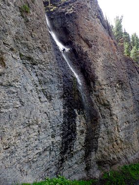
Bridalveil Creek (Ouray)
Jump to navigation
Jump to search
| Rating: | |||||||||||||||||||||||||||||||
|---|---|---|---|---|---|---|---|---|---|---|---|---|---|---|---|---|---|---|---|---|---|---|---|---|---|---|---|---|---|---|---|
| | Raps:
Red Tape:Closed to entry Shuttle: | ||||||||||||||||||||||||||||||
| Location: | |||||||||||||||||||||||||||||||
| Condition Reports: | 21 Jul 2012
"See the full condition report at Candition.com. Submitted by [http://www.candition.com/profile/G |
||||||||||||||||||||||||||||||
| Best season: | Jul-Sep (avg for this region)
|
||||||||||||||||||||||||||||||
| Regions: | |||||||||||||||||||||||||||||||
Introduction[edit]
Parts of this canyon, specifically the upper portion and the bottom closest to the road, are on private land. You can not exit this canyon without crossing private land, so it should be considered closed. The Ouray Canyon Club may be able to provide access. If you'd like to descend this canyon, contact them first via their web site.
Approach[edit]
Descent[edit]
Exit[edit]
Red tape[edit]
This canyon partially flows through private land, and should be considered closed. See the introduction for more information and who to contact to possibly get access.
Beta sites[edit]
 Super Amazing Map : Bridalveil Creek
Trip reports and media[edit]
 Candition.com : Bridal Veil Creek
