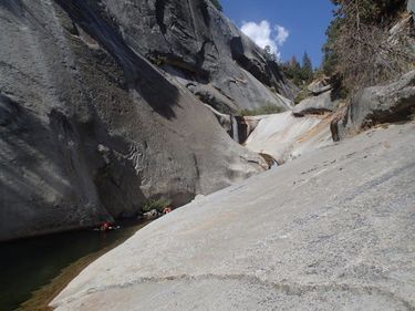
Buck Canyon (Lower)
| Rating: | |||||||||||||||||||||||||||||||
|---|---|---|---|---|---|---|---|---|---|---|---|---|---|---|---|---|---|---|---|---|---|---|---|---|---|---|---|---|---|---|---|
| | Raps:7-12, max ↨120ft
Red Tape:Permit required Shuttle:Optional Vehicle:Passenger Rock type:Granite | ||||||||||||||||||||||||||||||
| Location: | |||||||||||||||||||||||||||||||
| Condition Reports: | |||||||||||||||||||||||||||||||
| Best season: | Aug-Sept
|
||||||||||||||||||||||||||||||
| Regions: | |||||||||||||||||||||||||||||||
Introduction[edit]
Lower Buck Canyon has the sort of classic bedrock gorge one might hope for in the Sierra. Out of Lower Buck Canyon, Upper Buck Canyon, Lone Pine Creek, this canyon offers the longest technical section, jumps, slides, and the most fun. It would be the only one of the three worth doing on it's own, as with a shuttle, it could be done in two days. Still, I wouldn't recommend that approach.
Instead combine it as a backcountry trip with Lone Pine Creek, and Upper Buck Canyon. If you did a shuttle (though you'd have to get all your gear through Lower Buck Canyon) you could also end your trip through Panther Creek Gorge on the middle fork, which would be a great end for an epic adventure.
Approach[edit]
From the High Sierra Trail, boulder hop down Buck Creek. The bouldery section goes for a long ways, but is fairly enjoyable if you're into that sort of thing. As you pass under Sugarbowl Dome up to your left (hard to spot through the trees) you'll come to the technical section. This starts with a large sliding waterfall that drops in total probably around a hundred feet and can be bypassed on the right. Even if you skip this, some little slides in the canyon will likely soon draw you into the water.
Descent[edit]
Jumps rappels and swims follow through a green, vegetated gorge. After this first section you will see the West wall rise way up in front of you as you enter a deeper gorge with some fantastic waterfalls. A couple tributaries come in from the right to add flow. The crux of the canyon happens here, where a double drop is necessitated (unless you have a bolt kit) from a tree on the left, and down to the right. This will put you rappelling down a crack under the full force of the second drop. If flows are too high, you would likely need to bolt, or bypass this through the steep woods on the left, which looks not unreasonable, but not particularly pleasant.
A great slide follows, and another falls which can be bypassed on the right. Further down is an almost awesome slide, but a rock crease makes it look fairly painful, and a short rappel on the left is a better option. A final drop that falls 20 feet landing just in front of a boulder can be downclimbed on the left. The Middle Fork Trail bridge lays just downstream.
Exit[edit]
If you're doing this as a loop, head left up the Middle Fork Trail and enjoy the 5 miles and 2800 feet of climbing back up to Bearpaw Meadow!
Otherwise, turn right and head downstream. Panther Creek is about 6 miles downstream if you're finishing down the gorge. You will probably want to camp in between rather than attempt both canyons in the same day.
Red tape[edit]
You'll need a backcountry permit for the trip
